To install click the Add extension button. That's it.

The source code for the WIKI 2 extension is being checked by specialists of the Mozilla Foundation, Google, and Apple. You could also do it yourself at any point in time.

4,5
Kelly Slayton
Congratulations on this excellent venture… what a great idea!
Alexander Grigorievskiy
I use WIKI 2 every day and almost forgot how the original Wikipedia looks like.
Live Statistics
English Articles
Improved in 24 Hours
Added in 24 Hours
What we do. Every page goes through several hundred of perfecting techniques; in live mode. Quite the same Wikipedia. Just better.
.
Leo
Newton
Brights
Milds

Havelian Tehsil

From Wikipedia, the free encyclopedia

Havelian Tehsil

تحصیل حویلیاں
The valley of the Dor
Country Pakistan
ProvinceKhyber Pakhtunkhwa
DistrictAbbottabad
HeadquartersHavelian
Government
 • ChairmanUzair Sher Khan[1][2][3] (IND)
Population
 • Total351,322
Time zoneUTC+5 (PST)
Number of towns1
Number of Union Councils16

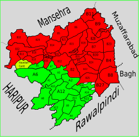
Havelian Tehsil is an administrative subdivision (tehsil) of Abbottabad District in the Khyber Pakhtunkhwa province of Pakistan.

History

During British rule, the current district of Abbottabad was created as a Tehsil of Hazara District.[5] After the independence of Pakistan it remained a tehsil of Hazara until 1981, when the old Abbottabad Tehsil became a district. Subsequently, the district was split into two tehsils, namely Abbottabad and Havelian.

Subdivisions

Municipal Committees

Cantonments

Union Councils

References

  1. ^ "Independent Candidate Uzair Sher Khan Claims Havelian Tehsil Chairman By-poll". UrduPoint website. 7 August 2023.
  2. ^ "JUIF defeated in Mathra LG by-polls". The News International newspaper. 7 August 2023.
  3. ^ "Uzair Sher wins slot of Havelian tehsil chairman". 24 News TV channel website. 6 August 2023.
  4. ^ "DISTRICT AND TEHSIL LEVEL POPULATION BLOCKWISE WITH REGION BREAKUP: KHYBER PAKHTUNKHWA (see page 26 of 36 for Havelian Tehsil)" (PDF). Pakistan Bureau of Statistics, Government of Pakistan website. Archived from the original (PDF) on 5 September 2018. Retrieved 5 November 2023.
  5. ^ Abbottābād  Tahsīl - Imperial  Gazetteer of India, v. 5, p. 1

33°56′N 73°07′E / 33.933°N 73.117°E / 33.933; 73.117

This page was last edited on 3 May 2024, at 20:53
Basis of this page is in Wikipedia. Text is available under the CC BY-SA 3.0 Unported License. Non-text media are available under their specified licenses. Wikipedia® is a registered trademark of the Wikimedia Foundation, Inc. WIKI 2 is an independent company and has no affiliation with Wikimedia Foundation.