

The Giant's Ring is a henge monument at Ballynahatty, near Shaw's Bridge, Belfast, Northern Ireland. It was originally preserved by Viscount Dungannon. The inscribed stone tablet on the wall surrounding the site which details Viscount Dungannon's interest was carved by Belfast stonecarver Charles A Thompson about c.1919.[citation needed]
The site is a State Care Historic Monument[1] and has ASAI (Area of Significant Archaeological Interest) status.[2]
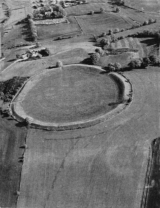
The site consists of a circular enclosure, 180 m (590 ft) in diameter and 2.8 hectares (6.9 acres) in area, surrounded by a circular earthwork bank 3.5 m (11 ft) high. At least three of the five irregularly spaced gaps in the bank are intentional and possibly original. East of the centre of the enclosure is a small passage tomb with a vestigial passage facing west. There were reports of other tombs outside the enclosure, but there is no trace of these.[3]
YouTube Encyclopedic
-
1/3Views:534789816
-
The Giant's Ring Belfast, Drone Footage
-
GIANT'S RING,BELFAST - A Megalithic Passage Tomb Monument from 2700 BC - Irish Ghost Stories
-
Giant's Ring, Lisburn, Northern Ireland - Ireland Road Trip - Giants Ring Belfast, Northern Ireland
Transcription
History
The Giant's Ring dates from the Neolithic period and was built around 2700BC,[4] meaning that it predates the Egyptian pyramids. The site has had some sort of public use throughout its history. It is near the Shaw's Bridge crossing of the River Lagan, a point which has been used as a crossing of the river since at least the Stone Age.[5] The original purpose of the monument was most likely as a meeting place or as a memorial to the dead.
Archaeologist Michael J. O'Kelly believed that the Giant's Ring, like hundreds of other passage tombs built in Ireland during the Neolithic period, such as Newgrange, showed evidence for a religion which venerated the dead as one of its core principles. He believed that this "cult of the dead" was just one particular form of European Neolithic religion, and that other megalithic monuments displayed evidence for different religious beliefs which were solar, rather than death-orientated.[6]
In the 18th century the site was used for horse racing.[7] A ritual site adjacent to the henge was excavated in the early 1990s by Barrie Hartwell of the Queen's University of Belfast.[8]

See also
References
- ^ "State Care Historic Monuments" (PDF). ehsni.gov.uk. Environment and Heritage Service. 31 March 2007. Archived from the original (PDF) on 22 July 2012. Retrieved 17 August 2012.
- ^ "Part 4, District Proposals: Lisburn Countryside Urban Environment". Belfast Metropolitan Area Plan 2015 (draft). Department of the Environment (Northern Ireland). November 2004. Retrieved 17 August 2012.
- ^ Weir, A (1980). Early Ireland. A Field Guide. Belfast: Blackstaff Press. p. 133.
- ^ Giants Ring
- ^ "Giant's Ring Trail, Belfast | Great British walks". 11 May 2012.
- ^ O'Kelly, Michael J. 1982. Newgrange: Archaeology, Art and Legend. London: Thames and Hudson. Page 122.
- ^ Giants Ring : Visit Lisburn : Lisburn Tourism Guide Lisburn City Guide Lisburn City Council Information Centre Northern Ireland Archived 2007-02-18 at the Wayback Machine
- ^ Hartwell, Barrie (1995). "The Prehistory of the Giant's Ring and Ballynahatty Townland". Lisburn Historical Society Journal. 9. Retrieved 17 August 2012.
Further reading
- Hartwell, Barrie (1995). "The Prehistory of the Giant's Ring and Ballynahatty Townland". Lisburn Historical Society Journal. 9. Retrieved 17 August 2012.
- Borlase, William C. (1897). "In the barony of Castlereagh upper". The Dolmens of Ireland. Vol. 1. London: Chapman & Hall. pp. 275–281. Retrieved 17 August 2012.
External links
- Aerial photograph of the Giant's Ring taken in 1984
- Photos of the Giant's Ring with rainbow
- Aerial Drone Footage of the Giant's Ring recorded by David Doyle, 2015
54°32′25″N 5°57′0″W / 54.54028°N 5.95000°W