
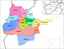
Ghurian
Ghoryan, غوريان | |
|---|---|
 | |
| Coordinates: 34°20′24″N 61°28′12″E / 34.34000°N 61.47000°E | |
| Country | |
| Province | Herat Province |
| Elevation | 2,590 ft (790 m) |
| Population | |
| • Total | 54,000 |
| Time zone | UTC+4:30 |
Ghurian (غوريان; Ghūrīān, Ghoryan, Ġūrīān) is a city and the administrative center of Ghurian District in Herat Province, Afghanistan. It is 790 m high with a population of more than 54,000 people.[1] It is situated south of the Hari River along the Mashhad-Herat highway at 34°20′N 61°28′E / 34.34°N 61.47°E. There is a local TV station and a health center. Ghurian is close to the old city of Pushang.[2] In 2020 Ghurian was connected by rail to Khaf in Iran.[3]
In the 19th century, Ghurian was a strategic town on the border between Herat and Iran, as one of the four provinces of the Principality of Herat.[4] It frequently swapped hands between the local chieftains. It was part of the Durrani Empire under Ahmad Shah, but was taken by the chieftain of Torbat-e Heydarieh, Eshaq Khan, in 1804.[4] In 1813-14 it was briefly held by Firuz al-Din, the ruler of Herat, but was soon restored to Eshaq Khan. When he died in 1816 it was taken by Banyad Khan Hazara, but later that same year it was captured by Firuz al-Din again and held until 1818, when Iran captured it and gave it to Qilij Khan Timuri. It was later taken by Mohammad Khan Qara'i, who held it until Qajar authorities deposed him in 1833. It was then taken by the Heratis until 1837, when Iran captured it and held it until 1841.[5][4]
YouTube Encyclopedic
-
1/3Views:2 3011 7653 929
-
Video #500 ! 77' Michael Gurian
-
How To Raise A Boy To Be A Great Man - Michael Gurian - 317
-
Michael Gurian on Brain Development and Writing
Transcription
See also
Notes
- ^ ""Ġūrīān" World Gazetteer". Archived from the original on 2013-02-09.
- ^ C. EDMUND BOSWORTH, FŪŠANJ[permanent dead link], Encyclopedia Iranica
- ^ "Long-delayed Herat-Khaf rail link inaugurated". Pajhwok Afghan News. 10 December 2020. Retrieved 2020-12-20.
- ^ a b c Noelle-Karimi, Christine (2014). The Pearl in Its Midst: Herat and the Mapping of Khurasan (15th-19th Centuries). Austrian Academy of Sciences Press. ISBN 978-3-7001-7202-4.[page needed]
- ^ Champagne, David C (1981). The Afghan-Iranian conflict over Herat Province and European intervention, 1796-1863: a reinterpretation (Thesis). OCLC 11054477.
| Districts | 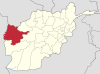 | |
|---|---|---|
| Populated places | ||
| Landmarks | ||
This Herat Province, Afghanistan location article is a stub. You can help Wikipedia by expanding it. |