
Size of this preview: 450 × 600 pixels. Other resolutions: 180 × 240 pixels | 480 × 640 pixels.
Original file (480 × 640 pixels, file size: 106 KB, MIME type: image/jpeg)
| This is a file from the Wikimedia Commons. Information from its description page there is shown below. Commons is a freely licensed media file repository. You can help. |
Summary
| Description |
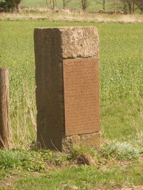
West Lavington: the Robbers Stone This memorial warns against the consequences of getting caught thieving:
"AT THIS SPOT Mr DEAN, of Imber, was Attacked and Robbed by Four Highwaymen, in the evening of Oct'r 21st 1839. After a spirited pursuit of three hours one of the Felons BENJAMIN COLCLOUGH fell Dead on Chitterne Down THOMAS SAUNDERS GEORGE WATERS & RICHARD HARRIS were eventually Captured and were convicted at the ensuing Quarter Sessions at Devizes, and Transported for the term of Fifteen Years. This Monument is erected by Public Conscription as a warning to those who presumptuously think to escape the punishment God has threatened against Thieves and Robbers" |
| Date | |
| Source | From geograph.org.uk |
| Author | Chris Downer |
| Attribution (required by the license) | Chris Downer / West Lavington: the Robbers’ Stone / |
| Camera location | | View this and other nearby images on: OpenStreetMap |
|---|
_heading:135.00&language=en)
| Object location | | View this and other nearby images on: OpenStreetMap |
|---|
_heading:135.00&language=en)
Licensing

|
This image was taken from the Geograph project collection. See this photograph's page on the Geograph website for the photographer's contact details. The copyright on this image is owned by Chris Downer and is licensed for reuse under the Creative Commons Attribution-ShareAlike 2.0 license.
|
This file is licensed under the Creative Commons Attribution-Share Alike 2.0 Generic license.
Attribution: Chris Downer
- You are free:
- to share – to copy, distribute and transmit the work
- to remix – to adapt the work
- Under the following conditions:
- attribution – You must give appropriate credit, provide a link to the license, and indicate if changes were made. You may do so in any reasonable manner, but not in any way that suggests the licensor endorses you or your use.
- share alike – If you remix, transform, or build upon the material, you must distribute your contributions under the same or compatible license as the original.
File history
Click on a date/time to view the file as it appeared at that time.
| Date/Time | Thumbnail | Dimensions | User | Comment | |
|---|---|---|---|---|---|
| current | 14:55, 26 February 2011 | | 480 × 640 (106 KB) | <bdi>GeographBot</bdi> | == {{int:filedesc}} == {{Information |description={{en|1=West Lavington: the Robbers Stone This memorial warns against the consequences of getting caught thieving: "AT THIS SPOT Mr DEAN, of Imber, was Attacked and Robbed by Four Highwaymen, in the |
File usage
The following pages on the English Wikipedia use this file (pages on other projects are not listed):
Global file usage
The following other wikis use this file:
- Usage on hi.wikipedia.org