

Size of this PNG preview of this SVG file: 800 × 388 pixels. Other resolutions: 320 × 155 pixels | 640 × 310 pixels | 1,024 × 496 pixels | 1,280 × 620 pixels | 2,560 × 1,241 pixels | 1,300 × 630 pixels.
Original file (SVG file, nominally 1,300 × 630 pixels, file size: 1.86 MB)
| This is a file from the Wikimedia Commons. Information from its description page there is shown below. Commons is a freely licensed media file repository. You can help. |
Summary
| Description |
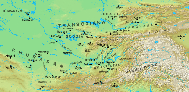
Map of the region and principal localities of Transoxiana in the 8th century —.
|
| Date | |
| Source | Own work |
| Author | Cplakidas |
| Other versions |
[]
|


Licensing
I, the copyright holder of this work, hereby publish it under the following license:
This file is licensed under the Creative Commons Attribution-Share Alike 3.0 Unported license.
- You are free:
- to share – to copy, distribute and transmit the work
- to remix – to adapt the work
- Under the following conditions:
- attribution – You must give appropriate credit, provide a link to the license, and indicate if changes were made. You may do so in any reasonable manner, but not in any way that suggests the licensor endorses you or your use.
- share alike – If you remix, transform, or build upon the material, you must distribute your contributions under the same or compatible license as the original.
File history
Click on a date/time to view the file as it appeared at that time.
| Date/Time | Thumbnail | Dimensions | User | Comment | |
|---|---|---|---|---|---|
| current | 15:30, 2 October 2016 | | 1,300 × 630 (1.86 MB) | Cplakidas | added Qunduz |
| 10:32, 15 October 2012 |  | 1,300 × 630 (1.86 MB) | Cplakidas | larger map to include most of Khurasan, additions of cities & provinces | |
| 13:29, 24 January 2012 |  | 800 × 500 (1 MB) | Cplakidas | major revision with more additions & corrections | |
| 17:28, 8 December 2011 |  | 800 × 500 (955 KB) | Cplakidas | added more details, some corrections | |
| 20:34, 25 July 2011 |  | 800 × 500 (895 KB) | Cplakidas |
File usage
The following pages on the English Wikipedia use this file (pages on other projects are not listed):
- Abd al-Malik I (Samanid emir)
- Abu Mansur Muhammad
- Abu Sahl Zawzani
- Ahmad Maymandi
- Ahmad ibn Sahl
- Akhsikath
- Al-Harith ibn Surayj
- Al-Muhallab ibn Abi Sufra
- Ali-Tegin
- Amr ibn Ma'adi Yakrib
- Asad ibn Abdallah al-Qasri
- Avicenna
- Azkajwar II
- Battle of Aksu (717)
- Battle of Baykand
- Battle of Kharistan
- Battle of Talas
- Battle of the Baggage
- Battle of the Defile
- Berkyaruq
- Böritigin
- Chaghaniyan
- Day of Thirst
- Farighunids
- Fergana Valley
- Greater Khorasan
- Ismail Samani
- Juday al-Kirmani
- Khurasan Road
- Khwarazmshah
- List of revolutions and rebellions
- Marw al-Rudh
- Masʽud I of Ghazni
- Mikalids
- Muslim conquest of Transoxiana
- Muslim conquests of Afghanistan
- Nasr I
- Nasr II
- Nasr ibn Sayyar
- Nuh II
- Principality of Farghana
- Principality of Khuttal
- Qutayba ibn Muslim
- Relief of Qasr al-Bahili
- Samanid Empire
- Seljuk (warlord)
- Shams al-Mulk Nasr
- Siege of Kamarja
- Tahir ibn Husayn
- Tokharistan
- Transoxiana
- Tughshada
- Umayya ibn Abdallah ibn Khalid ibn Asid
- Ya'qub ibn al-Layth al-Saffar
- Yazid ibn al-Muhallab
- Ziyad ibn Abihi
- Özgön
Global file usage
The following other wikis use this file:
- Usage on ar.wikipedia.org
- Usage on arz.wikipedia.org
- Usage on azb.wikipedia.org
- Usage on az.wikipedia.org
- Türkdilli dövlətlər
- Usruşana
- Börküyarıq
- Talas döyüşü
- Bahilə qalası uğrunda döyüş
- Susuzluq günü
- Ağsu döyüşü (717)
- Bəykənd döyüşü
- Vikipediya:Həftənin yaxşı məqaləsi/noyabr 2020
- Vikipediya:Həftənin yaxşı məqaləsi/dekabr 2020
- Vikipediya:Həftənin yaxşı məqaləsi/48. Həftə 2020
- Vikipediya:Həftənin yaxşı məqaləsi/49. Həftə 2020
- Böyük Xorasan
- Usage on bg.wikipedia.org
- Usage on bn.wikipedia.org
- Usage on bs.wikipedia.org
- Usage on ca.wikipedia.org
- Usage on cs.wikipedia.org
- Usage on de.wikipedia.org
- Usage on de.wikiversity.org
- Usage on el.wikipedia.org
- Usage on eo.wikipedia.org
View more global usage of this file.