

Size of this PNG preview of this SVG file: 637 × 600 pixels. Other resolutions: 255 × 240 pixels | 510 × 480 pixels | 816 × 768 pixels | 1,088 × 1,024 pixels | 2,176 × 2,048 pixels | 1,004 × 945 pixels.
Original file (SVG file, nominally 1,004 × 945 pixels, file size: 657 KB)
| This is a file from the Wikimedia Commons. Information from its description page there is shown below. Commons is a freely licensed media file repository. You can help. |
Summary
| Description |
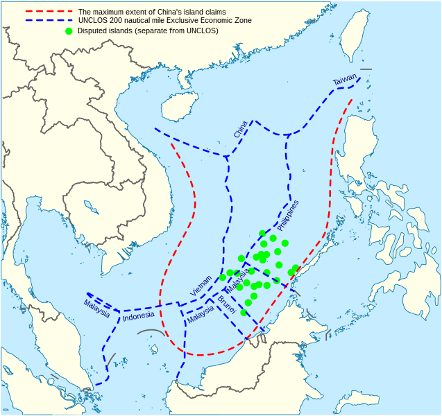
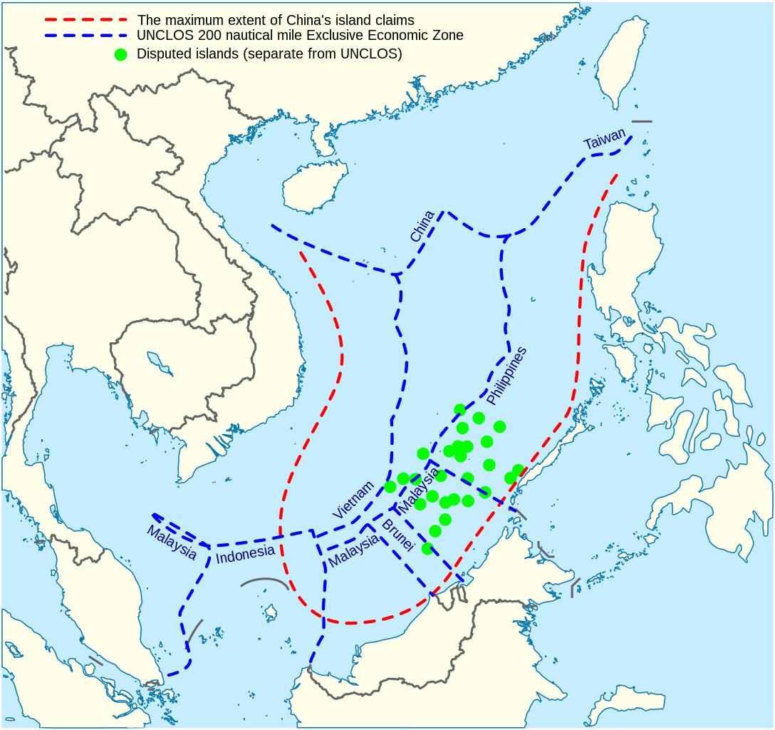
China's maritime claim (red) and UNCLOS exclusive economic zones (blue) in the South China Sea |
| Date | |
| Source |
Own work |
| Author | Goran tek-en |
| SVG development | This vector image was created with Inkscape. |


Licensing
This file is licensed under the Creative Commons Attribution-Share Alike 4.0 International license.
Attribution: Goran tek-en
- You are free:
- to share – to copy, distribute and transmit the work
- to remix – to adapt the work
- Under the following conditions:
- attribution – You must give appropriate credit, provide a link to the license, and indicate if changes were made. You may do so in any reasonable manner, but not in any way that suggests the licensor endorses you or your use.
- share alike – If you remix, transform, or build upon the material, you must distribute your contributions under the same or compatible license as the original.
File history
Click on a date/time to view the file as it appeared at that time.
| Date/Time | Thumbnail | Dimensions | User | Comment | |
|---|---|---|---|---|---|
| current | 14:31, 15 February 2022 | | 1,004 × 945 (657 KB) | ماني | File uploaded using svgtranslate tool (https://svgtranslate.toolforge.org/). Added translation for fa. |
| 15:44, 16 November 2021 |  | 1,004 × 945 (651 KB) | Goran tek-en | ppi to 96, optimized, cleaned up | |
| 19:40, 9 November 2014 |  | 1,004 × 945 (729 KB) | Cmglee | Label UNCLOS regions. | |
| 23:15, 19 May 2014 |  | 1,004 × 945 (723 KB) | Benlisquare | Fix misinformation, see en:Talk:Nine-dotted line. The red line represents the extent of China's island claims, and not sea territory claims. China's maritime territorial claims are based on distance from claimed islands, and are not demarcated by... | |
| 14:40, 23 January 2014 |  | 1,004 × 945 (722 KB) | Goran tek-en | User created page with UploadWizard |
File usage
The following pages on the English Wikipedia use this file (pages on other projects are not listed):
Global file usage
The following other wikis use this file:
- Usage on af.wikipedia.org
- Usage on cs.wikinews.org
- Usage on fa.wikipedia.org
- Usage on fi.wikipedia.org
- Usage on fr.wikinews.org
- Usage on fr.wiktionary.org
- Usage on ja.wikipedia.org
- Usage on kk.wikipedia.org
- Usage on ko.wikipedia.org
- Usage on pl.wikipedia.org
- Usage on ru.wikipedia.org
- Usage on th.wikipedia.org
- Usage on vi.wikipedia.org