

Size of this preview: 640 × 600 pixels. Other resolutions: 256 × 240 pixels | 903 × 846 pixels.
Original file (903 × 846 pixels, file size: 708 KB, MIME type: image/png)
| This is a file from the Wikimedia Commons. Information from its description page there is shown below. Commons is a freely licensed media file repository. You can help. |
Summary
| Description |
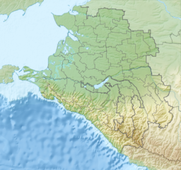
Русский: Физическая карта Краснодарского края, Россия.
|
| Date | |
| Source |
|
| Author | Nzeemin |
| Other versions |
|

Licensing
| Description |
This map was created from OpenStreetMap project data, collected by the community. This map may be incomplete, and may contain errors. Don't rely solely on it for navigation. |
| Date | (see file history) |
| Source | openstreetmap.org |
| Creator |
OpenStreetMap contributors |
| Permission (Reusing this file) |
OpenStreetMap data and maps are licensed under the Creative Commons Attribution-ShareAlike 2.0 license (CC-BY-SA 2.0). This file is licensed under the Creative Commons Attribution-Share Alike 2.0 Generic license.
|
| Georeferencing | If inappropriate please set warp_status = skip to hide. |
| Annotations | This image is annotated: View the annotations at Commons |
File history
Click on a date/time to view the file as it appeared at that time.
| Date/Time | Thumbnail | Dimensions | User | Comment | |
|---|---|---|---|---|---|
| current | 11:54, 9 March 2012 | | 903 × 846 (708 KB) | Nzeemin |
File usage
The following pages on the English Wikipedia use this file (pages on other projects are not listed):
- Abrau Peninsula
- Abzakhs
- Aibga Ridge
- Akhshtyrskaya Cave
- Alpine skiing at the 2014 Winter Olympics
- Belaya (Kuban)
- Besleney
- Beysug
- Bolshaya Laba
- Bolshoy Zelenchuk
- Chemirgoys
- Chushka Spit
- Circassians
- Dagomys (river)
- Dolgaya Spit
- Fars (river)
- Federation Island
- Hatuqway
- Ivanovsky Waterfall
- Kerch Strait
- Kuban (river)
- Kurdzhips
- Laba (river)
- Lake Khanskoye
- Mamkhegh
- Matsesta (river)
- Mount Tsakhvoa
- Mzymta
- Natukhajs
- Orekhovsky
- Polikarya
- Psefir
- Psekups (river)
- Pshish
- Russian conquest of the Caucasus
- Shakhe
- Shapsugs
- Sochi (river)
- Sochi National Park
- Taman Peninsula
- Teberda (river)
- Tuzla Spit
- Ubykh people
- Urup (river)
- Vorontsovka Caves
- Western Caucasus
- Yegeruqway
- Yeya
- Yeysk Spit
- Zhaney
Global file usage
The following other wikis use this file:
- Usage on ar.wikipedia.org
- Usage on az.wikipedia.org
- Usage on ba.wikipedia.org
- Usage on be.wikipedia.org
- Usage on bg.wikipedia.org
View more global usage of this file.