

Size of this PNG preview of this SVG file: 800 × 533 pixels. Other resolutions: 320 × 213 pixels | 640 × 427 pixels | 1,024 × 683 pixels | 1,280 × 853 pixels | 2,560 × 1,707 pixels | 1,200 × 800 pixels.
Original file (SVG file, nominally 1,200 × 800 pixels, file size: 316 KB)
| This is a file from the Wikimedia Commons. Information from its description page there is shown below. Commons is a freely licensed media file repository. You can help. |
Summary
| Description |
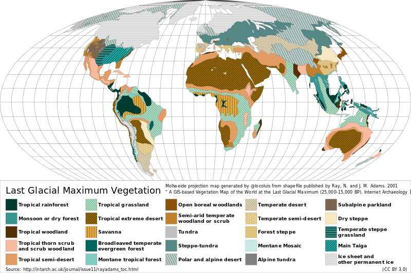
Reconstructed vegetation cover at the Last Glacial Maximum period ~18,000 years ago, describing the type of vegetation cover present, based on fossil pollen samples recovered from lake and bog sediments. |
| Date | |
| Source |
Map generated from shapefile published by Ray, N. and J. M. Adams. 2001, “ A GIS-based Vegetation Map of the World at the Last Glacial Maximum (25,000-15,000 BP). Internet Archaeology 11. ” Source: http://intarch.ac.uk/journal/issue11/rayadams_toc.html |
| Author | Locoluis |
| English | Spanish |
|---|---|
| Tropical rainforest | Selva tropical |
| Monsoon or dry forest | Monzón o bosque seco |
| Tropical woodland | Sabana arbolada tropical |
| Tropical thorn scrub and scrub woodland | Matorral espinoso tropical y bosque de matorral |
| Tropical semi-desert | Semi-desierto tropical |
| Tropical grassland | Pradera tropical |
| Tropical extreme desert | Desierto extremo tropical |
| Savanna | Sabana |
| Broadleaved temperate evergreen forest | Bosque siempreverde templado de hojas anchas |
| Montane tropical forest | Bosque tropical montano |
| Open boreal woodlands | Bosque boreal abierto |
| Semi-arid temperate woodland or scrub | Sabana arbolada o matorral templado semi-árido |
| Tundra | Tundra |
| Steppe-tundra | Estepa-tundra |
| Polar and alpine desert | Desierto polar y alpino |
| Temperate desert | Desierto templado |
| Temperate semi-desert | Semi-desierto templado |
| Forest steppe | Bosque estepa |
| Montane mosaic | Mosaico montano |
| Alpine tundra | Tundra alpina |
| Subalpine parkland | Zona verde subalpina |
| Dry steppe | Estepa seca |
| Temperate steppe grassland | Pastizal de estepa templada |
| Main Taiga | Taiga principal |
| Ice sheet and other permanent ice | Campos de hielo y otro hielos permanentes |
Licensing
This file is licensed under the Creative Commons Attribution 3.0 Unported license.
- You are free:
- to share – to copy, distribute and transmit the work
- to remix – to adapt the work
- Under the following conditions:
- attribution – You must give appropriate credit, provide a link to the license, and indicate if changes were made. You may do so in any reasonable manner, but not in any way that suggests the licensor endorses you or your use.
File history
Click on a date/time to view the file as it appeared at that time.
| Date/Time | Thumbnail | Dimensions | User | Comment | |
|---|---|---|---|---|---|
| current | 02:12, 23 August 2015 | | 1,200 × 800 (316 KB) | Locoluis | Minor font adjustments. Typo in original source. |
| 02:01, 23 August 2015 |  | 1,200 × 800 (316 KB) | Locoluis | User created page with UploadWizard |
File usage
The following pages on the English Wikipedia use this file (pages on other projects are not listed):
Global file usage
The following other wikis use this file:
- Usage on als.wikipedia.org
- Usage on ar.wikipedia.org
- Usage on bcl.wikipedia.org
- Usage on be.wikipedia.org
- Usage on ca.wikipedia.org
- Usage on cs.wikipedia.org
- Usage on da.wikipedia.org
- Usage on de.wikipedia.org
- Usage on el.wikipedia.org
- Usage on es.wikipedia.org
- Usage on fr.wikipedia.org
- Usage on fy.wikipedia.org
- Usage on ga.wikipedia.org
- Usage on hy.wikipedia.org
- Usage on it.wikipedia.org
- Usage on ja.wikipedia.org
- Usage on la.wikipedia.org
- Usage on mk.wikipedia.org
- Usage on nn.wikipedia.org
- Usage on no.wikipedia.org
- Usage on ru.wikipedia.org
- Usage on sv.wikipedia.org
- Usage on tr.wikipedia.org
- Usage on uk.wikipedia.org
View more global usage of this file.