

No higher resolution available.
Huc_region-edit.png (500 × 320 pixels, file size: 17 KB, MIME type: image/png)
| This is a file from the Wikimedia Commons. Information from its description page there is shown below. Commons is a freely licensed media file repository. You can help. |
Summary
| Description |
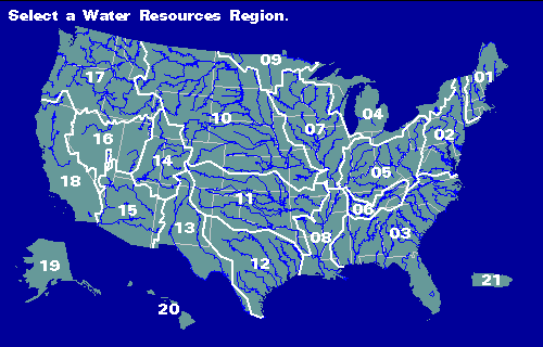
Map of the 21 "regions" of the USGS hydrologic unit system, AKA Watershed Boundary Dataset (see en:Hydrological code#United States). Region numbers and names listed below |
| Date | Unknown date |
| Source |
Image: http://pubs.usgs.gov/wri/wri934076/usimage/huc_region.gif Website: http://pubs.usgs.gov/wri/wri934076/ |
| Author | USGS |
Key
| Region Number | Name |
|---|---|
| 01 | New England |
| 02 | Mid-Atlantic |
| 03 | South Atlantic-Gulf |
| 04 | Great Lakes |
| 05 | Ohio |
| 06 | Tennessee |
| 07 | Upper Mississippi |
| 08 | Lower Mississippi |
| 09 | Souris-Red-Rainy |
| 10 | Missouri |
| 11 | Arkansas-White-Red |
| 12 | Texas-Gulf |
| 13 | Rio Grande |
| 14 | Upper Colorado |
| 15 | Lower Colorado |
| 16 | Great Basin |
| 17 | Pacific Northwest |
| 18 | California |
| 19 | Alaska |
| 20 | Hawaii |
| 21 | Caribbean |
Licensing
This image is in the public domain in the United States because it only contains materials that originally came from the United States Geological Survey, an agency of the United States Department of the Interior. For more information, see the official USGS copyright policy.
|
File history
Click on a date/time to view the file as it appeared at that time.
| Date/Time | Thumbnail | Dimensions | User | Comment | |
|---|---|---|---|---|---|
| current | 22:44, 16 November 2010 | | 500 × 320 (17 KB) | Pfly | {{Information |Description={{en|1=Map of the 21 "regions" of the USGS hydrologic unit system, AKA Watershed Boundary Dataset (see en:Hydrological code#United States).}} |Source=Image: http://pubs.usgs.gov/wri/wri934076/usimage/huc_region.gif Website |
File usage
The following pages on the English Wikipedia use this file (pages on other projects are not listed):