

Size of this preview: 800 × 526 pixels. Other resolutions: 320 × 211 pixels | 640 × 421 pixels | 1,024 × 674 pixels | 1,280 × 842 pixels | 2,284 × 1,503 pixels.
Original file (2,284 × 1,503 pixels, file size: 1.08 MB, MIME type: image/png)
| This is a file from the Wikimedia Commons. Information from its description page there is shown below. Commons is a freely licensed media file repository. You can help. |
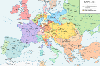
Map of Europe 1815, After the Congress of Vienna.
Summary
| Description |
Europe 1815. Political situation after the Congress of Vienna in June 1815. Please don't alter the map when you think there is something not written or depicted correctly. Leave a message at the talk page of the file. After a verificiation and a possible discussion, I will upload a new map version with all new changes. This prevents an unnecessary waste of disk space and ensures a good result, aesthetically and content-wise. - The author. |
| Date | |
| Source |
Own work. Source of Information: Historical atlases – Map "1815 - L'Europe après le Congrès de Vienne" (Author unknown)(Link) – Ramsay Muir, George Philip (ed.): Philip's New School Atlas of Universal History, George Philip & Son, Ltd., London 1928 – Dr. Walter Leisering (ed.): Putzger Historischer Weltatlas, Cornelsen Verlag, Berlin 1992, ISBN 3-464-00176-8 – Bayerischer Schulbuch-Verlag (ed.): Großer Historischer Weltatlas, Dritter Teil, Neuzeit, Bayerischer Schulbuch-Verlag, München 1981, ISBN 3-7627-6021-7. – Prof. Dr. Hans-Erich Stier, Prof. Dr. Ernst Kirsten a. o. (ed.): Großer Atlas zur Weltgeschichte, Orbis Verlag, München 1990, ISBN 3-7627-6021-7 Other publications – Reinhard Stauber: Der Wiener Kongress, Böhlau Verlag, Wien/Köln/Weimar 2014, ISBN 978-3-8252-4095-0 – Thierry Lentz: 1815. Der Wiener Kongress und die Neugründung Europas, Siedler Verlag, München 2014, ISBN 978-3-8275-0027-4 |
| Author | Alexander Altenhof |
| Other versions |
|

Recompressed without quality loss with OptiPNG (1.36 MB > 1.06 MB)
Licensing
I, the copyright holder of this work, hereby publish it under the following license:
This file is licensed under the Creative Commons Attribution-Share Alike 4.0 International license.
- You are free:
- to share – to copy, distribute and transmit the work
- to remix – to adapt the work
- Under the following conditions:
- attribution – You must give appropriate credit, provide a link to the license, and indicate if changes were made. You may do so in any reasonable manner, but not in any way that suggests the licensor endorses you or your use.
- share alike – If you remix, transform, or build upon the material, you must distribute your contributions under the same or compatible license as the original.

|
This map image could be re-created using vector graphics as an SVG file. This has several advantages; see Commons:Media for cleanup for more information. If an SVG form of this image is available, please upload it and afterwards replace this template with
{{vector version available|new image name}}.
It is recommended to name the SVG file “Europe 1815 map en.svg”—then the template Vector version available (or Vva) does not need the new image name parameter. |
File history
Click on a date/time to view the file as it appeared at that time.
| Date/Time | Thumbnail | Dimensions | User | Comment | |
|---|---|---|---|---|---|
| current | 23:36, 14 April 2017 | | 2,284 × 1,503 (1.08 MB) | KaterBegemot | Corrected "K. of Bavaria" caption / minor changes |
| 21:50, 11 September 2016 |  | 2,284 × 1,503 (1.36 MB) | KaterBegemot | Kingdom of Spain same green color like in the other maps | |
| 21:38, 11 September 2016 |  | 2,284 × 1,503 (1.06 MB) | KaterBegemot | Deleted black border at Austrian part of the German Confederation border, P. of Monaco smaller, corrected border at Tarnopol area, changed spacing of K. of Netherlands text | |
| 11:23, 20 July 2016 |  | 2,284 × 1,503 (1.07 MB) | KaterBegemot | {{Information |Description ={{en|1=Europe 1815. Political situation after the Congress of Vienna in June 1815.<br> ''Please don't alter the map, when you think there something not written or depicted correclty. Leave a mes... |
File usage
The following pages on the English Wikipedia use this file (pages on other projects are not listed):
- 1810s
- 19th century
- Balance of power (international relations)
- Concert of Europe
- Congress of Vienna
- Europe
- European balance of power
- Federal Convention (German Confederation)
- Former countries in Europe after 1815
- History of Austria
- History of Europe
- History of the Czech lands
- International relations (1814–1919)
- Karl August von Hardenberg
- Klemens von Metternich
- Monarchies in Europe
- Napoleonic Wars
- Secret Treaty of Vienna
- Timeline of Karl Marx
- Timeline of the 19th century
Global file usage
The following other wikis use this file:
- Usage on avk.wikipedia.org
- Usage on azb.wikipedia.org
- Usage on bg.wikipedia.org
- Usage on bs.wikipedia.org
- Usage on cs.wikipedia.org
- Usage on da.wikipedia.org
- Usage on el.wikipedia.org
- Usage on eml.wikipedia.org
- Usage on en.wikibooks.org
- Usage on en.wikiquote.org
- Usage on eo.wikipedia.org
- Usage on eo.wikiquote.org
- Usage on es.wikipedia.org
- Usage on et.wikipedia.org
- Usage on eu.wikipedia.org
- Usage on fa.wikipedia.org
- Usage on fi.wikipedia.org
- Usage on fr.wikipedia.org
- Usage on ha.wikipedia.org
- Usage on he.wikipedia.org
- Usage on hi.wikipedia.org
- Usage on hy.wikipedia.org
- Usage on it.wikipedia.org
- Usage on ja.wikipedia.org
- Usage on ka.wikipedia.org
- Usage on la.wikipedia.org
- Usage on lv.wikipedia.org
- Usage on mk.wikipedia.org
- Usage on mn.wikipedia.org
View more global usage of this file.