
Original file (4,928 × 3,280 pixels, file size: 7.97 MB, MIME type: image/jpeg)
| This is a file from the Wikimedia Commons. Information from its description page there is shown below. Commons is a freely licensed media file repository. You can help. |
Summary
| Description |
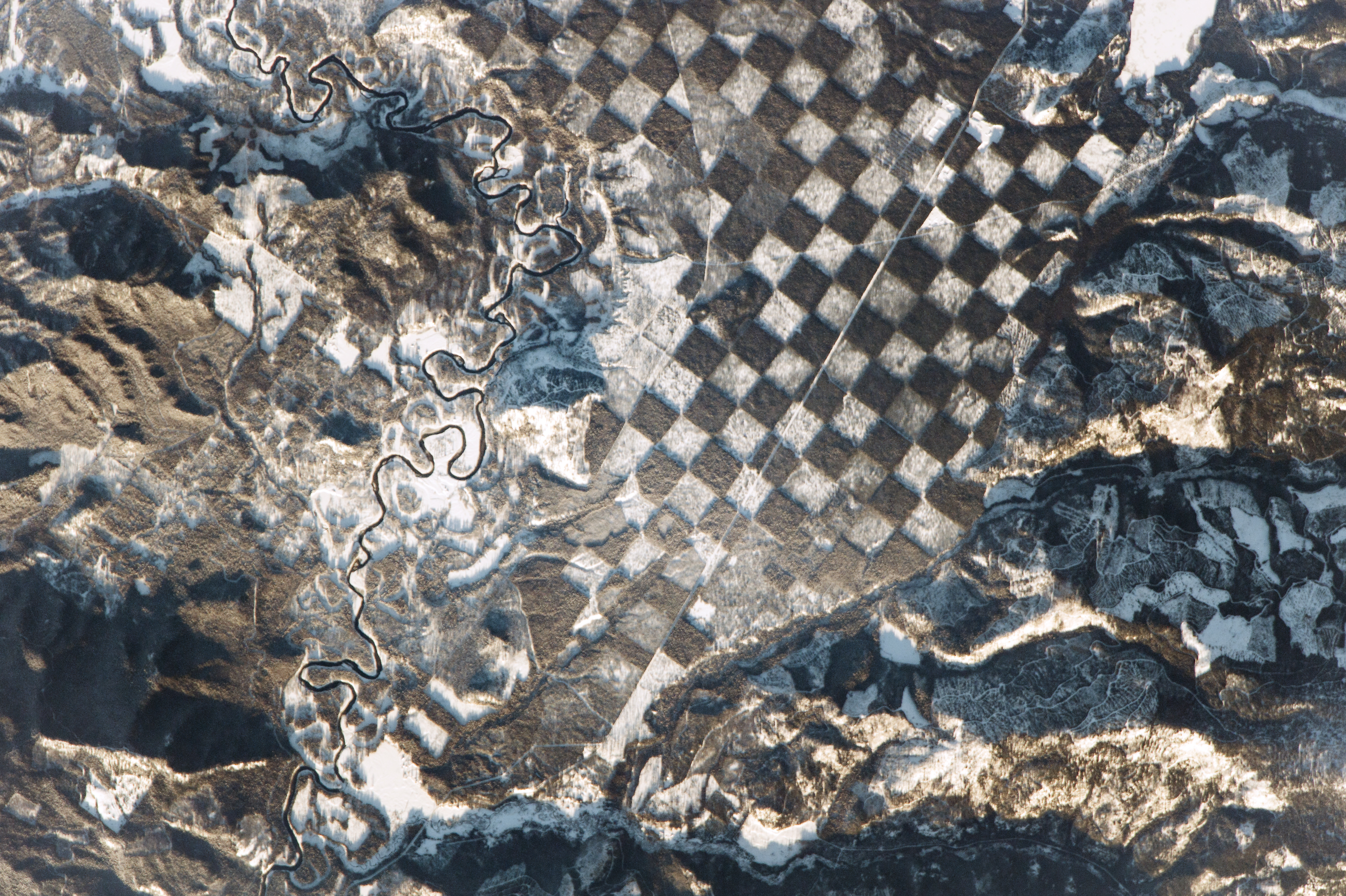
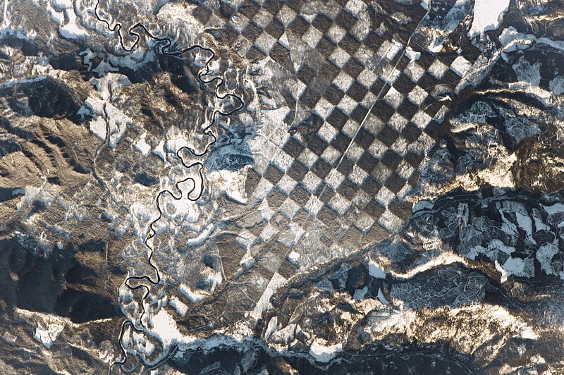
An astronaut aboard the International Space Station observed this distinctive checkerboard pattern alongside the Priest River in northern Idaho. The photograph was taken just before sunset, so some mountainsides glow while others are covered in long shadows because of the low Sun angle.
The quarter-mile (400 m) squares in this landscape checkerboard appear to be the result of forest management. Similar patterns originated in the 1800s, when alternate parcels of land were granted by the U.S. government to railroads such as the Northern Pacific. Many parcels in the Pacific Northwest were later sold off and harvested for timber. The land shown here is now managed for wildlife and for timber harvesting. The white patches reflect areas with younger, smaller trees, where winter snow cover shows up brightly to the astronauts. Dark green-brown squares are parcels of denser, intact forest. The checkerboard is used as a method of maintaining the sustainability of forested tracts while still enabling a harvest of trees. The Priest River, winding through the scene from top to bottom, is bordered on both sides by a forest buffer that can serve as a natural filtration system to protect water quality. For nearly a century, the river was used to transport logs. Its function changed in 1968 when the river’s main stem was added to a list of “wild and scenic rivers” in order to preserve its “outstanding natural, cultural, and recreational values in a free-flowing condition for the enjoyment of present and future generations.” Whitetail Butte has historically been used by state and federal land managers as a lookout point for forest fires. |
| Date | |
| Source | http://earthobservatory.nasa.gov/IOTD/view.php?id=89541&eocn=image&eoci=moreiotd |
| Author | "An astronaut aboard the International Space Station"—"a member of the Expedition 50 crew" |
| Camera location | | View this and other nearby images on: OpenStreetMap |
|---|
Astronaut photograph ISS050-E-28519 was acquired on January 4, 2017, with a Nikon D4 digital camera using an 1150 millimeter lens, and is provided by the ISS Crew Earth Observations Facility and the Earth Science and Remote Sensing Unit, Johnson Space Center. The image was taken by a member of the Expedition 50 crew. The image has been cropped and enhanced to improve contrast, and lens artifacts have been removed. The International Space Station Program supports the laboratory as part of the ISS National Lab to help astronauts take pictures of Earth that will be of the greatest value to scientists and the public, and to make those images freely available on the Internet. Additional images taken by astronauts and cosmonauts can be viewed at the NASA/JSC Gateway to Astronaut Photography of Earth. Caption by Andi Hollier, Hx5, and M. Justin Wilkinson, Texas State University, Jacobs Contract at NASA-JSC. The photo's vantage point was outer space but relative to the surface of the earth, it is rotated approximately 20° clockwise.
Licensing
| This file is in the public domain in the United States because it was solely created by NASA. NASA copyright policy states that "NASA material is not protected by copyright unless noted". (See Template:PD-USGov, NASA copyright policy page or JPL Image Use Policy.) | ||
 |
Warnings:
|

|
This image has been assessed under the valued image criteria and is considered the most valued image on Commons within the scope: Forests in Idaho, checkerboard forest photographed from the International Space Station.. You can see its nomination here. |
| Annotations | This image is annotated: View the annotations at Commons |
File history
Click on a date/time to view the file as it appeared at that time.
| Date/Time | Thumbnail | Dimensions | User | Comment | |
|---|---|---|---|---|---|
| current | 05:52, 7 February 2017 | | 4,928 × 3,280 (7.97 MB) | Koavf | {{Information |Description ={{en|1=An astronaut aboard the International Space Station observed this distinctive checkerboard pattern alongside the Priest River in northern Idaho. The photograph was taken just before sunset, so some mountainsides gl... |
File usage
Global file usage
The following other wikis use this file:
- Usage on hu.wikipedia.org