

Original file (2,400 × 1,652 pixels, file size: 546 KB, MIME type: image/jpeg)
| This is a file from the Wikimedia Commons. Information from its description page there is shown below. Commons is a freely licensed media file repository. You can help. |
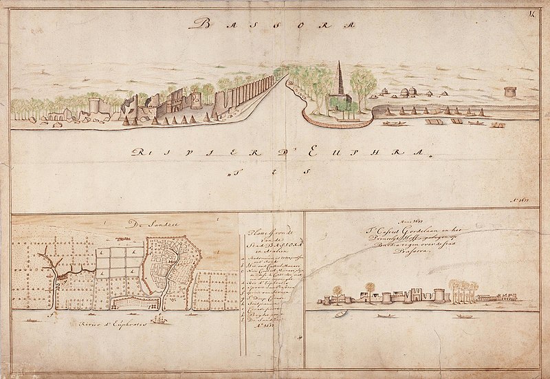
Summary
Nederlands: Gezicht op Basra en kasteel 'Gordelaan'
English: View of Basra and 'Gordelaan' castle( |
||||||||||||||||||||||||||
|---|---|---|---|---|---|---|---|---|---|---|---|---|---|---|---|---|---|---|---|---|---|---|---|---|---|---|
| Author |
Nederlands: Isaac de Graaff (landmeter / kaartenmaker)
English: Isaac de Graaff (land surveyor / mapmaker) |
|||||||||||||||||||||||||
| Title |
Nederlands: Gezicht op Basra en kasteel 'Gordelaan'
English: View of Basra and 'Gordelaan' castle |
|||||||||||||||||||||||||
| Description |
Nederlands: Titel catalogus Leupe (NA): Gezigt op Bassora.
Datering: Ca. 1695 naar de situatie van 1677. Ter versteviging is rondom een uitstekende rand papier geplakt, het formaat van de eigenlijke kaart is 48,5 x 70,5 cm. Rechtsboven genummerd: 14. Notities verso: 499 a.English: Title in the Leupe catalogue (National Archives): Gezigt op Bassora.
Dated around 1695 after the situation in 1677. A paper strip runs round all four sides of the chart by way of reinforcement, the dimensions of the actual map are 48.5 by 70.5 cm. Numbered top right: 14. Notes on reverse: 499a. |
|||||||||||||||||||||||||
| Date | between 1690 and 1743 | |||||||||||||||||||||||||
| Medium |
Nederlands: ingekleurde tekening op papier
English: coloured drawing on paper |
|||||||||||||||||||||||||
| Dimensions | height: 77 cm (30.3 in); width: 56 cm (22 in) | |||||||||||||||||||||||||
| Collection |
|
|||||||||||||||||||||||||
| Accession number |
NL-HaNA_4.VEL_863 (old number: VEL0863) |
|||||||||||||||||||||||||
| Inscriptions |
Bassora
|
|||||||||||||||||||||||||
| Notes |
English: Subjects: key, palace, remains / ruin, ship / vessel, cemetery / graveyard, survey / view
Nederlands: Onderwerpen: legenda, paleis, restant / ruïne, schip / vaartuig, begraafplaats / kerkhof, overzicht / aanzicht
English: Post: this image is related to a VOC trading post called Al Basrah |
|||||||||||||||||||||||||
| Source/Photographer |
|
|||||||||||||||||||||||||
| Permission (Reusing this file) |
|
|||||||||||||||||||||||||

| Object location | | View this and other nearby images on: OpenStreetMap |
|---|
.jpg)
File history
Click on a date/time to view the file as it appeared at that time.
| Date/Time | Thumbnail | Dimensions | User | Comment | |
|---|---|---|---|---|---|
| current | 18:03, 10 June 2014 | | 2,400 × 1,652 (546 KB) | HuskyBot | == {{int:filedesc}} == {{Artwork |title = {{nl|1=Gezicht op Basra en kasteel 'Gordelaan'}} {{en|1=View of Basra and 'Gordelaan' castle}} |description = {{nl|1=Titel catalogus Leupe (NA): ''Gezigt op Bassora''.... |
File usage
Global file usage
The following other wikis use this file:
- Usage on ar.wikipedia.org
- Usage on sl.wikipedia.org
- Usage on th.wikipedia.org
- Usage on tr.wikipedia.org