
Drawsko County
Powiat drawski | |
|---|---|
 Flag  Coat of arms | |
 Location within the voivodeship | |
 Division into gminas | |
| Coordinates (Drawsko Pomorskie): 53°32′N 15°48′E / 53.533°N 15.800°E | |
| Country | |
| Voivodeship | West Pomeranian |
| Seat | Drawsko Pomorskie |
| Gminas | |
| Area | |
| • Total | 1,764.21 km2 (681.17 sq mi) |
| Population (2015) | |
| • Total | 58,062 |
| • Density | 33/km2 (85/sq mi) |
| • Urban | 35,764 |
| • Rural | 22,309 |
| Car plates | ZDR |
| Website | http://www.powiatdrawski.pl |
Drawsko County (Polish: powiat drawski) is a unit of territorial administration and local government (powiat) in West Pomeranian Voivodeship, north-western Poland. It came into being on January 1, 1999, as a result of the Polish local government reforms passed in 1998. Its administrative seat is the town of Drawsko Pomorskie, which lies 82 kilometres (51 mi) east of the regional capital Szczecin. The county contains three other towns: Złocieniec, 15 km (9 mi) east of Drawsko Pomorskie, Czaplinek, 29 km (18 mi) east of Drawsko Pomorskie, and Kalisz Pomorski, 29 km (18 mi) south of Drawsko Pomorskie.
The county covers an area of 1,764.21 square kilometres (681.2 sq mi). As of 2015 its total population is 58,062, out of which the population of Złocieniec is 13,377, that of Drawsko Pomorskie is 11,465, that of Czaplinek is 6,933, that of Kalisz Pomorski is 3,989, and the rural population is 22,309.
The eastern part of the county contains part of the protected area known as Drawsko Landscape Park.
YouTube Encyclopedic
-
1/3Views:7334802 116
-
Konotop Branch Poland
-
Suliszewo Gmina Drawsko Pomorskie
-
Marina dla żeglarzy w Camping WAJK nad jeziorem Drawsko www.wajk.pl
Transcription
Neighbouring counties
Drawsko County is bordered by Świdwin County to the north, Szczecinek County and Złotów County to the east, Wałcz County to the south-east, Choszczno County to the south, Stargard County to the west, and Łobez County to the north-west.
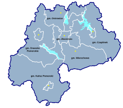
Administrative division
The county is subdivided into six gminas (four urban-rural and two rural). These are listed in the following table, in descending order of population.
| Gmina | Type | Area (km2) |
Population (2006) |
Seat |
| Gmina Drawsko Pomorskie | urban-rural | 344.8 | 16,537 | Drawsko Pomorskie |
| Gmina Złocieniec | urban-rural | 194.5 | 15,571 | Złocieniec |
| Gmina Czaplinek | urban-rural | 364.7 | 11,795 | Czaplinek |
| Gmina Kalisz Pomorski | urban-rural | 480.5 | 7,150 | Kalisz Pomorski |
| Gmina Wierzchowo | rural | 229.3 | 4,489 | Wierzchowo |
| Gmina Ostrowice | rural | 150.4 | 2,531 | Ostrowice |
See also
Seat: Drawsko Pomorskie | ||
| Urban-rural gminas |  | |
| Rural gminas | ||
| City counties |
|  |
|---|---|---|
| Land counties | ||