
Dell Prairie, Wisconsin | |
|---|---|
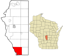 Location in Adams County and the state of Wisconsin. | |
 Dell Prairie  Dell Prairie | |
| Coordinates: 43°41′7″N 89°46′14″W / 43.68528°N 89.77056°W | |
| Country | |
| State | |
| County | Adams |
| Area | |
| • Total | 33.1 sq mi (85.8 km2) |
| • Land | 31.9 sq mi (82.7 km2) |
| • Water | 1.2 sq mi (3.2 km2) |
| Elevation | 988 ft (301 m) |
| Population | |
| • Total | 1,631 |
| • Density | 49/sq mi (19/km2) |
| Time zone | UTC-6 (Central (CST)) |
| • Summer (DST) | UTC-5 (CDT) |
| Area code | 608 |
| FIPS code | 55-19575[3] |
| GNIS feature ID | 1583071[1] |
Dell Prairie is a town in Adams County in the U.S. state of Wisconsin. The population was 1,631 at the 2020 census, up from 1,590 at the 2010 census.[4] The unincorporated community of Plainville is located in the town.
YouTube Encyclopedic
-
1/5Views:751 1183 6896 730508347 779
-
10 Places in Wisconsin You Should NEVER Move To
-
Wisconsin Hometown Stories: Sauk Prairie
-
Great River Road Trip Tour | Minnesota & Wisconsin [4K UHD]
-
Prairie River
-
AVOID LIVING IN A 55 PLUS COMMUNITY - Unless you can HANDLE These FACTS
Transcription
Geography
Dell Prairie is located at 43°21′22″N 89°44′52″W / 43.35611°N 89.74778°W (43.689600, −89.748050).[5]
According to the United States Census Bureau, the town has a total area of 33.1 square miles (85.8 km2), of which 31.9 square miles (82.7 km2) is land and 1.2 square miles (3.2 km2), or 3.69%, is water.[4] The western boundary of the town is formed by the Wisconsin River, which flows through the Upper Wisconsin Dells along the southern part of the town boundary. The city of Wisconsin Dells extends north from Columbia County into land along the Wisconsin River that was formerly in Dell Prairie.
Demographics
As of the census[3] of 2000, there were 1,415 people, 553 households, and 403 families residing in the town. The population density was 42.4 people per square mile (16.4/km2). There were 754 housing units at an average density of 22.6 per square mile (8.7/km2). The racial makeup of the town was 96.89% White, 0.64% African American, 1.48% Native American, 0.49% Asian, and 0.49% from two or more races. Hispanic or Latino of any race were 1.34% of the population.
There were 553 households, out of which 29.7% had children under the age of 18 living with them, 62.7% were married couples living together, 6.0% had a female householder with no husband present, and 27.1% were non-families. 21.3% of all households were made up of individuals, and 8.0% had someone living alone who was 65 years of age or older. The average household size was 2.51 and the average family size was 2.89.
In the town, the population was spread out, with 22.7% under the age of 18, 6.1% from 18 to 24, 27.1% from 25 to 44, 30.1% from 45 to 64, and 14.0% who were 65 years of age or older. The median age was 41 years. For every 100 females, there were 107.8 males. For every 100 females age 18 and over, there were 103.0 males.
The median income for a household in the town was $43,750, and the median income for a family was $47,750. Males had a median income of $32,356 versus $22,563 for females. The per capita income for the town was $19,209. About 5.2% of families and 7.8% of the population were below the poverty line, including 10.2% of those under age 18 and 8.7% of those age 65 or over.
Education
It is in the service area of the School District of Wisconsin Dells,[6] which operates Spring Hill Middle School and Wisconsin Dells High School.
References
- ^ a b "US Board on Geographic Names". United States Geological Survey. October 25, 2007. Retrieved January 31, 2008.
- ^ "Census Bureau profile: Dell Prairie town, Adams County, Wisconsin". United States Census Bureau. May 2023. Retrieved May 29, 2024.
- ^ a b "U.S. Census website". United States Census Bureau. Retrieved January 31, 2008.
- ^ a b "Geographic Identifiers: 2010 Demographic Profile Data (G001): Dell Prairie town, Adams County, Wisconsin". U.S. Census Bureau, American Factfinder. Archived from the original on February 12, 2020. Retrieved August 30, 2013.
- ^ "US Gazetteer files: 2010, 2000, and 1990". United States Census Bureau. February 12, 2011. Retrieved April 23, 2011.
- ^ "About Us." School District of Wisconsin Dells. Retrieved on November 16, 2018.
Municipalities and communities of Adams County, Wisconsin, United States | ||
|---|---|---|
| Cities |  | |
| Village | ||
| Towns | ||
| CDPs | ||
| Unincorporated communities | ||
| Ghost towns | ||
| Indian reservation | ||
| Footnotes | ‡This populated place also has portions in an adjacent county or counties | |