
Nickname: Big Witch | |
|---|---|
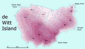 Detailed map of De Witt Island | |
| Etymology | Cornelis Jan Witsen, a Commissioner of the Dutch East India Company[1] |
| Geography | |
| Location | South West Tasmania |
| Coordinates | 43°35′24″S 146°21′00″E / 43.59000°S 146.35000°E |
| Archipelago | Maatsuyker Islands Group |
| Adjacent to | Southern Ocean |
| Area | 516 ha (1,280 acres)[2]: 18 |
| Width | 3 km (1.9 mi)[3] |
| Highest elevation | 340 m (1120 ft)[3] |
| Administration | |
Australia | |
| State | Tasmania |
| Region | South West |
| Demographics | |
| Population | Unpopulated |
| Additional information | |
| Register of the National Estate | |

De Witt Island, also known as Big Witch, is an island located close to the south-western coast of Tasmania, Australia. The 516-hectare (1.99 sq mi) island is the largest of the Maatsuyker Islands Group, and comprises part of the Southwest National Park and the Tasmanian Wilderness World Heritage Site. The island is listed on the Australian Register of the National Estate.[2]
YouTube Encyclopedic
-
1/3Views:1 176 64439 6951 312
-
What's an Ion?
-
Shoppingtown Mall | Another Moonbeam Dead Mall Failure in DeWitt New York | ExLog 58
-
Saugerties Real Estate | 20 Dewitt Drive Saugerties NY 12477 | Catskills Real Estate
Transcription
Location and features
De Witt Island lies some 6 kilometres (3.7 mi) south of Louisa Bay, on Tasmania's south coast. Abel Tasman discovered it in 1642 and named it Witsen or Wits Eijlanden.[1] The island is broadly triangular in shape, some 3 kilometres (1.9 mi) across, with cliffs ranging from 250 to 300 metres (820 to 980 ft) high to the south on all sides except a part of the central north coast. The highest parts of the island are located very close to the south coast, and enclose a north-facing basin. The island's 340-metre (1,120 ft) summit is located very close to its southernmost point.[3] Although currently uninhabited, it has a long history of human usage, including logging and occasional habitation.[2][4] The island is part of the Maatsuyker Island Group Important Bird Area, identified as such by BirdLife International because of its importance as a breeding site for seabirds.[5]
The island is extensively forested with the principal species being Eucalyptus nitida, swamp gum and messmate. Sheltered areas also have leatherwood and myrtle beech.[2]
Recorded breeding seabird and wader species are the little penguin (500 pairs), short-tailed shearwater (11,000 pairs), fairy prion (50 pairs), silver gull and sooty oystercatcher. Swift parrots have been recorded. Mammals present include the Tasmanian pademelon, long-nosed potoroo and swamp rat. Reptiles recorded are the metallic skink and Tasmanian tree skink.[2][4]
See also

References
- ^ a b Heeres, J. E., ed. (2006). "Abel Janszoon Tasman's Journal of his Discovery of Van Diemen's Land and New Zealand in 1642 with Documents Relating to his Exploration of Australia in 1644...to which are added his Life and Labours, 1898". Project Gutenberg of Australia]. Retrieved 9 July 2006.
- ^ a b c d e "Small Southern Islands Conservation Management Statement 2002" (PDF). Tasmania Parks and Wildlife Service. 2002. Archived from the original (PDF) on 22 August 2006. Retrieved 20 July 2006.
- ^ a b c Dixon, G.; Houshold, I (1996). "Notes on the geology and geomorphology of De Witt Island, southwest Tasmania". Papers and Proceedings of the Royal Society of Tasmania. 130 (1): 67–74. doi:10.26749/rstpp.130.1.67. ISSN 0080-4703.
- ^ a b Brothers, Nigel; Pemberton, David; Pryor, Helen; & Halley, Vanessa. (2001). Tasmania’s Offshore Islands: seabirds and other natural features. Tasmanian Museum and Art Gallery: Hobart. ISBN 0-7246-4816-X
- ^ "Important Bird Area factsheet: Maatsuyker Island Group". Archived from the original on 23 May 2023. Retrieved 23 May 2023.
This Tasmania geography article is a stub. You can help Wikipedia by expanding it. |