
Craigellachie | |
|---|---|
 | |
| Coordinates: 50°58′31″N 118°43′25″W / 50.97528°N 118.72361°W | |
| Country | |
| Province | |
| Region | BC Interior |
| Regional district | Columbia-Shuswap Regional District |
| Land district | Kamloops Division Yale Land District |
| Time zone | UTC−8 (PST) |
| • Summer (DST) | UTC−7 (PDT) |
| Postal code span | |
| Area code | 250 / 778 / 236 |
| Highways | Trans-Canada Highway |
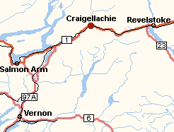
Craigellachie (pronounced /krəˈɡɛləxi, -hi/) is a locality in British Columbia, located several kilometres to the west of the Eagle Pass summit between Sicamous and Revelstoke.[1] Craigellachie is the site of a tourist stop on the Trans-Canada Highway between Salmon Arm and Revelstoke.
It was named after the village of Craigellachie on the River Spey in Moray, Scotland, the ancestral home of Sir George Stephen, the first president of the Canadian Pacific Railway (CPR). At a critical time in the railway's development, Stephen travelled to Britain to raise desperately needed capital funding; when he succeeded, he telegraphed his associates in Canada quoting the familiar motto of Clan Grant: "Stand fast, Craigellachie!"
The Canadian Craigellachie is most famous for being the site of the "Last Spike" of the CPR, driven by Sir Donald Smith, a director of the CPR, on November 7, 1885.[2]
YouTube Encyclopedic
-
1/3Views:3091 5951 267
-
The Last Spike at Craigellachie @ Canadian Railway # Beauty of British Columbia Canada 🇨🇦Mountains
-
The Last Spike, British Columbia, Canada
-
Epic Canada Road Trip | Ep. 1 - The Last Spike, Craigellachie
Transcription
Gallery
-

Sir Donald Smith drives the last spike at Craigellachie
-

Craigellachie station
-

"Last Spike" memorial
References
- ^ "Craigellachie (community)". BC Geographical Names.
- ^ In fact, Sir Donald drove in two spikes; his first attempt resulted in a bent spike and so the Last Spike was a replacement.
External links
 Media related to Craigellachie, British Columbia at Wikimedia Commons
Subdivisions of British Columbia | |
|---|---|
| Subdivisions | |
| Communities | |
| Metro areas and agglomerations | |
50°58′31″N 118°43′25″W / 50.97528°N 118.72361°W