
Central Instrumentation Facility | |
Formerly listed on the U.S. National Register of Historic Places | |
 | |
  | |
| Location | Brevard County, Florida, USA |
|---|---|
| Nearest city | Titusville, Florida |
| Coordinates | 28°31′27″N 80°39′22″W / 28.52417°N 80.65611°W |
| Built | 1965 |
| Architect | Charles Luckman |
| Architectural style | International |
| Visitation | n/a |
| MPS | John F. Kennedy Space Center MPS |
| NRHP reference No. | 99001635[1] |
| Significant dates | |
| Added to NRHP | c. 1974 |
| Removed from NRHP | 21 January 2000 |
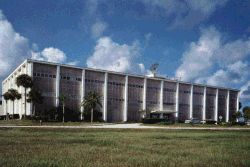
The Central Instrumentation Facility (CIF) was a building in the Kennedy Space Center industrial area that functioned as the core of instrumentation and data processing operations during the Apollo program and the early years of the Space Shuttle program. It centralized the handling of the center's data including offices, laboratories and test stations; and housed general instrumentation activities serving more than one launch complex.[2] The CIF also included the Central Timing Facility, where a precision clock drove countdown clocks and other timing devices at KSC that required a high degree of accuracy.
The CIF also housed computers and other electronic equipment for reduction of telemetry data, analysis, and transmission to other NASA centers. The three-story structure of approximately 134,335 sq ft (12,480.1 m2) just west of the KSC Headquarters Building was one of the most distinctive buildings in the KSC Industrial Area with its rooftop array of various antennas.[2]
The CIF was left dormant during the intermediate part of the space shuttle program (as other facilities such as the launch control center managed most of the instrumentation in the 2000s), and fell into disrepair. In September 2017, all the equipment inside was donated to the visitor complex and storage facilities, while the disused building was eventually demolished in October.[3]
YouTube Encyclopedic
-
1/3Views:1 787430934
-
Space Station Live: Window Observational Research Facility
-
High Bay Research Facility Grand Opening || Aug. 17, 2017
-
Precision Surveying | Aerial LiDAR | Central Research Facility
Transcription
>> What better way to celebrate Earth Day than to talk about a facility onboard the station that does just that. It studies Earth. It's called the Window Observational Research Facility and it's managed here in Marshall Space Flight Center. And joining me now is the project manager Yancy Young. Yancy, first of all, tell us about this facility. We call it WORF for short, right? >> Right. WORF was designed to be used in conjunction with the window in the Destiny Laboratory. It's currently on board, installed over the window. It serves two functions: That's basically to provide resources in the environment required by the Earth Science payloads, as well as protect the window itself from any inadvertent damage which could be caused by, you know, floating objects or incidental contact by the crew. >> What makes this unique? There are lots of things where you can take a picture and look out and look down at Earth, but what makes this one unique? >> Well, if you think about it's sort of like in your home at night to look out the window. You know, if the light's on in your room and you're trying to look out, what you see is your reflection of the room in that window, but if you cut that light off, then you can see outside the house. Well, similar with WORF and with the window in Destiny. When there's light in the background, it reflects off the window and it causes, you know, reflections and distorts the image. So WORF was designed, it's payload volume, it's coated with a nonreflective nonglaring finish to sort of give like a darkroom sort of say so that it's completely dark so that the cameras can see out the window. It also -- you know, another thing with Earth Science observations is they need stability. They don't need to be shaken around 'cause that can distort the image, you know, get jitter in there. So the rack itself was designed specifically to minimize any type of vibration; it could be from, you know, the crew or just the station operations in general from being transmitted up into the instrument. >> Wow. So you've had a lot of investigations use this facility. Tell us about some of those and some of the things we've seen. >> Okay. Well, we have what we call three residents so far of WORF. It's been on orbit since about 2010. So roughely about three years now. The first is called EarthKAM which stands for Earth Knowledge Acquired by Middle School Students, and it's basically it's a digital camera that's operated by a Web interface with students, and, say, if you have a middle school, say, here in Huntsville for example, it's studying some part of the globe [inaudible] on the other side of the world, and they want to take a picture of that area to support their studies or some type of hypothesis they're discussing in class, they can, you know, command through the Web interface, take a picture of that area, have it transferred back to them so they can see what they're actually studying about. >> A great learning tool. >> Yes, it is. Yes, it is. >> So you've just have ISSAC, another camera, wrap up work in the facility, correct? >> That's right, Lori. ISSAC, which stands for the ISS Agricultural Camera was developed by the University of North Dakota, and their objective's basically to look at the northern Great Plain areas, Montana, Wyoming, the Dakotas, parts of Minnesota, looking at agricultural uses of the land. It was a near infrared instrument, so they could tell by the chlorophyll action of the vegetation, you know, what was dry, what was too wet, what was overfertilized, what was underfertilized. >> So the images showed them this? >> It picks up the heat from the ground basically, and they can tell by the shades of the red, like I said, what's been overfertilized, underfertilized, too wet, too dry, and they take this information and send it out to the community of farmers, ranchers, the land resource managers, and they can use this information for the following season, you know, when they get ready to do their planting or harvesting to look at kind of need to put more water here, less water here, may apply additional fertilizer or, you know, less fertilizer to, you know, to increase the yield of the crops. >> So we moved ISSAC out so that ISERV could move in. Tell us about that. >> Well, ISERV serve which is the ISS Severe Environmental Research and Visualization System just went in the WORF in January, and it's a joint venture between NASA and the U.S. Agency for International Development, and they look at areas like Africa, Central American, South American, parts of the Himalayas, and they also look at land usage as well as disaster relief. >> So a lot of users in this facility, correct? >> Yes, ma'am. We're very excited about that. We actually have a new investigation hopefully coming online late next year called Meteor, which will be looking at how meteors enter the atmosphere fear and disperse. >> So for folks here on Earth who don't know why this facility would be so important to them, tell us why that is. >> That's a really good question, especially since, you know, Earth Day's coming along and we're stepping back as a community and looking at how we manage, how we're good stewards of the Earth its resources. And WORF and the instruments we support enable us to, you know, take images and acquire data not only of our atmosphere, of oceans, and the land resources, it helps us better understand how not only maybe effects we as humans induce on our environment, but also those that nature actually induces well. You know, maybe that one day will help us come up with better mitigation techniques to be better stewards. >> A lot off usage, and I don't think you'll have any trouble finding people. Maybe we need another window up there? >> Hey, I'm all for it. I'll see what I can do. >> All right. Thanks, Yancy. >> Thank you, Lori. [ Silence ]
History

The CIF reflected the desire of Karl Sendler, KSC's first director of information systems, and his planners to centralize data handling. Although it was based on systems developed during Saturn I operations at Complexes 34 and 37, such experience was of limited value, because the distance from Launch Complex 39 to its Launch Control Center was more than 14 times as long. Planning and construction were coordinated with other NASA centers and with the Atlantic Missile Range. All metal in the building was grounded, and commercial power and the instrumentation power systems were grounded separately. Fluorescent lights, a source of electromagnetic interference, were not permitted.[2] Its architect, Charles Luckman, also designed other nearby buildings.
CIF antenna site
A smaller building, later known as the CIF antenna site, was placed 1.5 miles (2.5 km) north of the Industrial Area, to be free of radio-frequency interference and have clear line-of-sight to the NASA launch complexes.[4]
References
- ^ "National Register Information System – Central Instrumentation Facility (#99001635)". National Register of Historic Places. National Park Service. 9 July 2010.
- ^ a b c Benson, Charles D.; Faherty, William Barnaby (1978), Moonport: A History of Apollo Launch Facilities and Operations, Scientific and Technical Information Office, National Aeronautics and Space Administration.
- ^ "Timelapse: Central Instrumentation Facility Demolition". Retrieved November 8, 2022.
- ^ Bidgood to CE Jacksonville, "Central Instrumentation Facility, MILA," 10 May 1963; B. Baker, memo for record, "Siting of the CIF," 22 Aug. 1963.44
![]() This article incorporates public domain material from websites or documents of the National Aeronautics and Space Administration.
This article incorporates public domain material from websites or documents of the National Aeronautics and Space Administration.