
Central | |
|---|---|
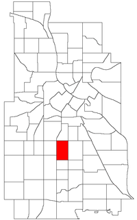 Location of Central within the U.S. city of Minneapolis | |
| Country | United States |
| State | Minnesota |
| County | Hennepin |
| City | Minneapolis |
| Community | Powderhorn |
| City Council Wards | 8, 9 |
| Government | |
| • Council Member | Andrea Jenkins |
| • Council Member | Jason Chavez |
| Area | |
| • Total | 0.582 sq mi (1.51 km2) |
| Population (2020)[2] | |
| • Total | 8,132 |
| • Density | 14,000/sq mi (5,400/km2) |
| Time zone | UTC-6 (CST) |
| • Summer (DST) | UTC-5 (CDT) |
| ZIP code | 55407, 55408, 55409 |
| Area code | 612 |
| Census | Pop. | Note | %± |
|---|---|---|---|
| 1980 | 7,147 | — | |
| 1990 | 7,521 | 5.2% | |
| 2000 | 8,150 | 8.4% | |
| 2010 | 8,307 | 1.9% | |
| 2020 | 8,132 | −2.1% |
The Central neighborhood (part of the larger Powderhorn community) of Minneapolis, Minnesota, United States is located south of the downtown region of the city. It is bounded by Lake Street on the north, Chicago Avenue on the east, 38th Street on the south, and Interstate 35W on the west. It should not be confused with the Central community, which covers Downtown and some surrounding neighborhoods.
Central is split between two city council wards along Portland Avenue and 36th Street. The western portion is in Ward 8, represented by Andrea Jenkins. The eastern portion is in Ward 9, represented by Jason Chavez.[3]
Developed mostly between 1900 and 1930, the Central neighborhood is racially diverse and has drawn African-American residents since the 1920s. Until it was closed in 1982 and later razed, Central High School was located here (Prince graduated from Central in 1976). 44°56′29″N 93°16′15″W / 44.9415°N 93.2709°W[4]
In 2010, the population of the neighborhood was 8,307. The neighborhood was 21.1% White, 25.1% Black or African American, 2.2% American Indian or Alaska Native, 3.6% Asian or Pacific Islander, 44.3% Hispanic or Latino, 3.4% two or more races, and 0.2% other race. The percentage of households with children was higher than the city average, and the percentage of single households was lower than the city average. The median household income was $36,988, which was $8,637 lower than the city average.[2]
YouTube Encyclopedic
-
1/3Views:1 6792 600646
-
New Minneapolis Central Library Grand Opening
-
4241 Park Ave S 5 bed, 2 bath, South Minneapolis Only $184,900
-
Our Somali Neighbors: Learning More about Somali Culture and Community
Transcription
References
- ^ "Central neighborhood in Minneapolis, Minnesota (MN), 55407, 55408, 55409 detailed profile". City-Data. 2011. Retrieved 2013-11-12.
- ^ a b "Central neighborhood data". Minnesota Compass. Retrieved 2023-02-19.
- ^ "Find My Ward". City of Minneapolis. Retrieved 19 April 2024.
- ^ Central, Minneapolis, MN. Google Earth. Retrieved 2011-03-09.
External links
Places adjacent to Central (neighborhood), Minneapolis | |
|---|---|