
| Black Forest National Park | |
|---|---|
| Nationalpark Schwarzwald | |
 The Huzenbacher See, one of several tarns in the national park | |
 Location of the Black Forest National Park in the northwestern Black Forest | |
| Location | Baden-Württemberg, Germany |
| Nearest city | Baden-Baden, Freudenstadt |
| Coordinates | 48°33′40″N 8°13′17″E / 48.56111°N 8.22139°E |
| Area | 10,062 ha (24,860 acres) |
| Established | 1 January 2014 |
| www | |

The Black Forest National Park (German: Nationalpark Schwarzwald) is a national park in the state of Baden-Württemberg in the southwest of Germany.
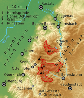
It has an area of 10,062 hectares (100.62 km2; 38.85 sq mi) and is located on the main crest of the Northern Black Forest, mainly between the Black Forest High Road (Schwarzwaldhochstraße) and the valley of the Murg. It comprises two separate areas, roughly 3.5 kilometres apart, around Ruhestein (7,615 ha) and Hoher Ochsenkopf/Plättig (2,447 ha) and is part of the Central/North Black Forest Nature Park (Naturpark Schwarzwald Mitte/Nord). The park was officially opened on 3 May 2014[1]
YouTube Encyclopedic
-
1/3Views:59 27053 73114 568
-
Black Forest (Schwarzwald) in Southwest Germany
-
Black Forest, Germany
-
Westweg - An Adventure In The Black Forest, Westweg Schwarzwald.
Transcription
Schwarzwald, or in english The Black Forest is located in the southwest corner of Germany in the German federal-state of Baden-Württemberg. The Black Forest is a mountainous terrain at about 200-1500 meters above sea level, the highest point being the Feldberg at 1493 m. This ancient forest is famous for its legends and the black fir trees that dot the landscape. While not particularly high, the mountains offer a wonderful place to go hiking or mountain biking with well-marked trails. Maps available from the tourist offices. There are a few skiing resorts as well offering average but crowded conditions. The region is famous for its cuckoo clocks, watchmaking, skiing and tourism. There is a large high-tech light engineering industry in the region stemming from the gold-mining and watchmaking days. Almost all tourists are from Germany and Switzerland; the region's tourist industry is therefore not well equipped to deal with guests who don't speak German. The most important destination in the Schwarzwald is called Titisee, which is a medium-sized lake with associated tourist village and hotels, with very nice views and generally very relaxed and healthy activities. From here it is a short journey to Lake Constance and the city of Konstanz, or to see the Rhein Waterfall at Neuhausen in Switzerland. Accommodations in the main tourist areas may be cheaper than many of the quaint smaller towns and villages. For a nice hut at a reasonable price, look for a privately-operated Gasthaus, which can be found in villages throughout the area. There are many pleasant surprises waiting, often with excellent home-cooked food and special service, often provided by the family living there for many generations.
History
The Black Forest National Park was created on 1 January 2014 and is the first national park in Baden-Württemberg, Germany. The state parliament voted for its establishment on 28 November 2013.[2]
The establishment of the first national park in the Black Forest was politically controversial. In 2013, it was opposed by Baden-Württemberg's opposition parties (CDU and FDP), by representatives of the timber industry and by some of the affected population, whilst being supported by the SPD and Greens, the conservation associations and other parts of the populations of the Northern Black Forest.[3][4] It is the first and only national park in Baden-Württemberg.
In 2021 the minister for environment Thekla Walker (A90/The Greens) announced plans to extent the national park and eventually connect the two parts in the following years.[5][6]
Location and extent
The northern part of the area, the High Ochsenkopf / Plättig includes the upper Schwarzenbach valley and the regions around the High Ochsenkopf (1,055 m above sea level (NHN)) in the centre, the Mehliskopf (1,008 m) in the west, the Badener Höhe (1,003 m) in the north and the Nägeliskopf (994 m) in the east. The lowest and most easterly point of this park is at the confluence of the Schwarzbach and Raumünzach streams, at a height of just below 500 m. Excluded are the village of Herrenwies as well as smaller areas around Plättig, Sand and the youth hostel of Badener Höhe. In the northeast, it borders to the Schwarzenbach Reservoir, and in the west to the Bühlerhöhe beyond the Black Forest High Road. Most of the state forest here belongs to the municipality of Forbach (in the county of Rastatt). The towns of Bühl (Rastatt) and Baden-Baden own other municipal forests in the area around Plättig.
The greater part of the Ruhestein area extends reaches a height of approximately 1,150 m above NHN near Dreifürstenstein in the southeasternmost summit region of the Hornisgrinde, the highest mountain in the northern Black Forest. Other summits are the bird's head (Vogelskopf) (1,056 m) and the Schliffkopf (1,054 m) to the west, the Seekopf (1,054 m) in the northwest, the Riesenköpfle (1,001 m) in the centre, the Leinkopf (992 m) in the north and the Großhahnberg (940 m) in the northeast. In this southern part of the National Park are the tarns of Wildsee, Huzenbacher See and Buhlbachsee and the upper Schönmünz valley and the headwaters of the Murg headstreams, the Rechtmurg and Rotmurg and other Murg tributaries. On the western slopes of the Schliffkopf this subregions extends down as far as the All Saints Waterfalls, where it reaches is lowest and most westerly point at a height of approximately 500 m. Excluded from the Ruhestein area are the Ruhestein itself with its two ski slopes and the Great Ruhestein Ski Jump, the Darmstädter Hut, the Schliffkopf Hotel, the Rotmurg Hunting Lodge, the hamlet of Schonmünz (Volzenhäuser) and other small areas. The state forest land here belongs mainly to the collective municipality of Baiersbronn (in the county of Freudenstadt), other elements belong to Oppenau, Ottenhöfen and Seebach (in the county of Ortenaukreis).[7][8]
The park covers an area of 10,062 hectares, of which 2,447 hectares are within the High Ochsenkopf/Plättig and 7,615 hectares around the Ruhestein. The two areas are separated by the Forbach parish of Hundsbach.

.jpg)
References
- ^ with the motto "Eine Spur wilder": Das wilde Herz beginnt zu schlagen (press release) at www.baden-wuerttemberg.de
- ^ Nationalpark im Schwarzwald Archived 2014-01-03 at the Wayback Machine Website of the Baden-Württemberg Ministry of Rural Affairs and Consumer Protection. Retrieved 30 November 2013
- ^ WELT (2013-11-28). "Grün-rotes Projekt: Der umstrittene Nationalpark Schwarzwald kommt". DIE WELT. Retrieved 2020-08-28.
- ^ Baden-Württemberg: Streit um Nationalpark (in German), retrieved 2020-08-28
- ^ ""Lücke soll weg": Nationalpark Schwarzwald soll größer werden". www.schwarzwald-aktuell.eu (in German). 2022-11-12. Retrieved 2023-09-25.
- ^ ""Die Erweiterung ist ein folgerichtiger Schritt"". Baden-Württemberg.de (in German). 2021-11-30. Retrieved 2023-09-25.
- ^ Gesetzentwurf der Landesregierung, Drucksache 15/4127 dated 8 October 2013 (pdf; 11 MB). Contains detailed mapping.
- ^ Nationalpark Schwarzwald – Übersichtskarte Archived December 12, 2013, at the Wayback Machine, Anlage 1 zu § 2 Absatz 1 NLPG (PDF; 2,56 MB), retrieved 8 December 2013
External links
- Official website of the Black Forest National Park Archived 2021-10-24 at the Wayback Machine
- NABU's website on the Black Forest National Park
| North Germany | ||
|---|---|---|
| Central Germany | ||
| South Germany | ||
| International | |
|---|---|
| National | |