

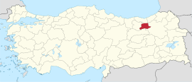
Bayburt Province (Turkish: Bayburt ili; Armenian: Բայբեդ գավառ) is a province of Turkey. Located in the Northeast Anatolia region of the country, the capital city is Bayburt. Its area is 3,746 km2,[2] and its population is 84,241 (2022), making it the least-populous province in Turkey.[1] The province was created in 1989 from part of Gümüşhane Province.[3][4]
YouTube Encyclopedic
-
1/1Views:216 471
-
10 Most Mysterious Discoveries Found Underground
Transcription
Geography
Bayburt is traversed by the northeasterly line of equal latitude and longitude.
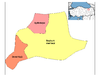
Districts

Bayburt province is divided into 3 districts (capital district in bold):
Historical sites, places and museums

The most important places in Bayburt Province are:[5]
- Bayburt Tower
- Saruhan Tower
- Aydıntepe underground city
- Mausoleum of Dede Korkut
- Mausoleum of Şehit Osman
- Traditional Bayburt houses
- Ulu Mosque
- Pulur (Gökçedere) Ferahşat Bey Mosque
- Sünür (Çayıryolu) Kutlu Bey Mosque
- Yukarı Hınzeverek (Çatalçeşme) Mosque
- Bedesten (covered bazaar)
- Varzahan Armenian Church
- Baksi Art Museum
- Bayburt Museum
- Kenan Yavuz Etnograpia Museum
Cities and towns
- Bayburt City 32,141 inh.
- Aydıntepe City 2,663 inh.
- Gökçedere Town 2,389 inh.
- Demirözü City 2,137 inh.
- Arpalı Town 1,934 inh.
- Konursu Town 1,569 inh.
Climate
The climate is described as Humid Continental by the Köppen Climate System, abbreviated as Dfb.[6]
See also
References
- ^ a b "Address-based population registration system (ADNKS) results dated 31 December 2022, Favorite Reports" (XLS). TÜİK. Retrieved 19 September 2023.
- ^ "İl ve İlçe Yüz ölçümleri". General Directorate of Mapping. Retrieved 19 September 2023.
- ^ Kanun No. 3578, Resmî Gazete, 21 June 1989.
- ^ "İl İdaresi ve Mülki Bölümler Şube Müdürlüğü İstatistikleri - İl ve İlçe Kuruluş Tarihleri" (PDF) (in Turkish). p. 17. Retrieved 25 October 2023.
- ^ Bayburt Tarihi yerler Archived May 10, 2012, at the Wayback Machine (in Turkish)
- ^ Climate Summary for Bayburt
External links
- (in Turkish) Bayburt governor's official website
- (in English) Bayburt weather forecast information

| International | |
|---|---|
| National | |
| Geographic | |
40°14′12″N 40°13′25″E / 40.23667°N 40.22361°E
This geographical article about a location in Bayburt Province, Turkey is a stub. You can help Wikipedia by expanding it. |