
Buôn Ma Thuột
Thành phố Buôn Ma Thuột Ban Mê Thuột, Lạc Giao | |
|---|---|
| Buôn Ma Thuột City | |
From top to bottom, left to right: City center. Buôn Ma Thuột city square seen from above, Buôn Ma Thuột cathedral, Khải Đoan pagoda, Buôn Ma Thuột central intersection Buôn Mê Thuột stadium | |
|
Seal | |
 | |
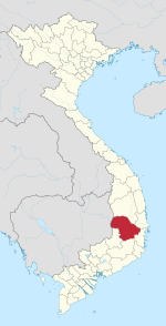
 Buôn Ma Thuột Location of in Vietnam  Buôn Ma Thuột Buôn Ma Thuột (Southeast Asia)  Buôn Ma Thuột Buôn Ma Thuột (Asia) | |
| Coordinates: 12°40′N 108°3′E / 12.667°N 108.050°E | |
| Country | |
| Province | Đắk Lắk |
| Area | |
| • City (Class-1) | 377.18 km2 (145.63 sq mi) |
| Elevation | 536 m (1,759 ft) |
| Population (2019 census) | |
| • City (Class-1) | 375,590 |
| • Density | 1,000/km2 (2,600/sq mi) |
| • Urban | 245,951 |
| Time zone | UTC+7 (ICT) |
| Website | buonmathuot |


12°40′N 108°3′E / 12.667°N 108.050°E Buôn Ma Thuột (formerly Lạc Giao)[1] or sometimes Buôn Mê Thuột or Ban Mê Thuột (), is the capital city of Đắk Lắk Province in the Central Highlands of Vietnam. Its population was 375,590 in 2019.[2] The city is the largest in Vietnam's Central Highlands region and is famous as the regional "capital of coffee".[3][4][5]
Buôn Ma Thuột has Buôn Ma Thuột Airport as its main airport.
YouTube Encyclopedic
-
1/1Views:571 117
-
Buôn Ma Thuột: Thành phố miền núi lớn nhất Việt Nam
Transcription
Names
The name Buôn Ma Thuột derives from the language of the Ê Đê people. A possible interpretation of this language is the village of Father Thuot. Father Thuot, or Ama Y Thuot, held considerable power and prestige as the governing figure of Buon Ma Thuot Village during the late 19th century.[6][7]
History
In 1904 Đắk Lắk Province was established by the French and Buôn Ma Thuột was selected as the provincial administrative centre, rather than the trading center of Đôn on the Srepok River. Buôn Ma Thuột was originally settled by the Ê Đê, but due to the incoming Việt settlement after the Vietnam War and the active acculturation policy, less than 15% (around 40,000) are still Montagnards. An important battle took place there at the end of the Vietnam war.
Geography

The city is located at 12.6667° N 108.0500° E, right at the heart of the Central Highlands of Vietnam, 1300 km from Hanoi, 500 km from Da Nang, and 350 km from Ho Chi Minh City. Lying on a fairly flat highland, at an average height of 536 m (1,759 ft) above sea level, Buôn Ma Thuột has a vital role in Vietnam's national security and defense system.[citation needed] Buôn Ma Thuột is the capital of Đắk Lắk Province and also the biggest city in the Central Highlands region (Tây Nguyên).
Institutions
Buôn Ma Thuột is the site of Tây Nguyên University, which was founded in 1977 and has educated more than 27,000 students. The TNU offers training in 37 university programs, 8 college programs, and 6 college-university interlinking programs and pre-university programs.[8]
Climate
| Climate data for Buôn Ma Thuột, elevation 490 m (1,610 ft) | |||||||||||||
|---|---|---|---|---|---|---|---|---|---|---|---|---|---|
| Month | Jan | Feb | Mar | Apr | May | Jun | Jul | Aug | Sep | Oct | Nov | Dec | Year |
| Record high °C (°F) | 34.3 (93.7) |
36.6 (97.9) |
37.6 (99.7) |
39.4 (102.9) |
37.0 (98.6) |
35.1 (95.2) |
34.6 (94.3) |
34.6 (94.3) |
33.1 (91.6) |
33.1 (91.6) |
32.6 (90.7) |
32.4 (90.3) |
39.4 (102.9) |
| Mean daily maximum °C (°F) | 27.1 (80.8) |
29.6 (85.3) |
32.0 (89.6) |
33.3 (91.9) |
31.8 (89.2) |
29.9 (85.8) |
29.2 (84.6) |
29.0 (84.2) |
28.9 (84.0) |
28.4 (83.1) |
27.2 (81.0) |
26.2 (79.2) |
29.4 (84.9) |
| Daily mean °C (°F) | 21.0 (69.8) |
22.5 (72.5) |
24.5 (76.1) |
26.1 (79.0) |
25.8 (78.4) |
24.9 (76.8) |
24.3 (75.7) |
24.2 (75.6) |
24.0 (75.2) |
23.5 (74.3) |
22.5 (72.5) |
21.2 (70.2) |
23.7 (74.7) |
| Mean daily minimum °C (°F) | 17.5 (63.5) |
18.2 (64.8) |
19.6 (67.3) |
21.4 (70.5) |
22.0 (71.6) |
21.7 (71.1) |
21.3 (70.3) |
21.4 (70.5) |
21.1 (70.0) |
20.5 (68.9) |
19.6 (67.3) |
18.3 (64.9) |
20.2 (68.4) |
| Record low °C (°F) | 9.1 (48.4) |
12.0 (53.6) |
12.3 (54.1) |
13.0 (55.4) |
14.4 (57.9) |
17.9 (64.2) |
14.4 (57.9) |
17.0 (62.6) |
13.4 (56.1) |
12.3 (54.1) |
10.7 (51.3) |
7.4 (45.3) |
7.4 (45.3) |
| Average rainfall mm (inches) | 5.2 (0.20) |
3.8 (0.15) |
24.1 (0.95) |
84.3 (3.32) |
233.6 (9.20) |
245.1 (9.65) |
253.7 (9.99) |
309.8 (12.20) |
311.4 (12.26) |
198.8 (7.83) |
100.3 (3.95) |
26.4 (1.04) |
1,784.3 (70.25) |
| Average rainy days | 1.6 | 0.8 | 3.4 | 7.8 | 18.5 | 21.2 | 23.4 | 24.2 | 23.2 | 15.7 | 10.6 | 5.8 | 156.1 |
| Average relative humidity (%) | 77.6 | 74.2 | 72.0 | 72.8 | 80.2 | 84.8 | 86.1 | 87.4 | 88.4 | 86.5 | 84.5 | 82.1 | 81.4 |
| Mean monthly sunshine hours | 249.7 | 249.4 | 265.1 | 253.4 | 226.2 | 185.4 | 180.5 | 162.6 | 153.5 | 168.5 | 170.9 | 188.6 | 2,450.4 |
| Source 1: Vietnam Institute for Building Science and Technology[9] | |||||||||||||
| Source 2: The Yearbook of Indochina (1930-1931 and 1932-1933)[10] [11] | |||||||||||||
See also
References
- ^ "Buon Me Thuot" Encyclopædia Britannica (2009 edition) Encyclopædia Britannica Online, accessed 24 September 2009
- ^ "Buôn Ma Thuột (District-level City, Đắk Lắk, Vietnam) - Population Statistics, Charts, Map and Location". www.citypopulation.de. Retrieved 2024-02-07.
- ^ "Buon Ma Thuot, the capital of coffee". THE VOICE OF VIETNAM. 2015-04-09. Retrieved 2020-01-26.
- ^ "Dak Lak – The capital of Vietnamese coffee". Archived from the original on 2021-10-27. Retrieved 2020-01-26.
- ^ Learning, Innovative Language; Com, Vietnamesepod101. Learn Vietnamese (in Vietnamese).
{{cite book}}: CS1 maint: numeric names: authors list (link) - ^ "The process of the formation of Buôn Ma Thuột in DakLak through various historical periods". Daklak Department of Finance. February 17, 2024.
- ^ SemiColonWeb; Lắk, Bảo tàng Đắk. "ĐÔI ĐIỀU VỀ TÊN GỌI THÀNH PHỐ BUÔN MA THUỘT". daklakmuseum.vn. Retrieved 2024-02-17.
- ^ "HOME". www.ttn.edu.vn. Retrieved 2020-01-26.
- ^ "Vietnam Institute for Building Science and Technology" (PDF).
- ^ The Yearbook of Indochina (1930-1931)
- ^ The Yearbook of Indochina (1932-1933)
External links
- "Establishing Buon Ma Thuot City and Adjusting the Border Between it and the Districts of Cu Jut, Ea Sup and Krong Pac of Darlac Province" Laws of Vietnam, Decree 8-CP, 21 January 1995
- "Buon Ma Thuot, Vietnam" Falling Rain Genomics, Inc.


| International | |
|---|---|
| National | |
| Geographic | |
Capital: Buôn Ma Thuột | ||
| Buôn Ma Thuột |
|  |
| Buôn Hồ |
| |
| Buôn Đôn District | ||
| Cư Kuin District |
| |
| Cư M'gar District | ||
| Ea H'leo District | ||
| Ea Kar District | ||
| Ea Súp District |
| |
| Krông Ana District | ||
| Krông Bông District |
| |
| Krông Buk District |
| |
| Krông Năng District |
| |
| Krông Pắk District |
| |
| Lắk District |
| |
| M'Đrăk District | ||