To install click the Add extension button. That's it.

The source code for the WIKI 2 extension is being checked by specialists of the Mozilla Foundation, Google, and Apple. You could also do it yourself at any point in time.

4,5
Kelly Slayton
Congratulations on this excellent venture… what a great idea!
Alexander Grigorievskiy
I use WIKI 2 every day and almost forgot how the original Wikipedia looks like.
What we do. Every page goes through several hundred of perfecting techniques; in live mode. Quite the same Wikipedia. Just better.
.
Leo
Newton
Brights
Milds

From Wikipedia, the free encyclopedia

Amtsberg
Old manor house
Old manor house
Coat of arms of Amtsberg
Location of Amtsberg within Erzgebirgskreis district
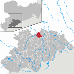
SaxonyAmtsbergAnnaberg-BuchholzAue-Bad SchlemaAuerbachBärensteinLauter-BernsbachBockauBörnichenBreitenbrunnBurkhardtsdorfCrottendorfDeutschneudorfDrebachEhrenfriedersdorfEibenstockElterleinGelenauGeyerGornauGornsdorfGroßolbersdorfGroßrückerswaldeGrünhain-BeierfeldGrünhainichenHeidersdorfHohndorfJahnsdorfJohanngeorgenstadtJöhstadtKönigswaldeLauter-BernsbachLößnitzLugauMarienbergMildenauNeukirchenNiederdorfNiederwürschnitzOberwiesenthalOelsnitzOlbernhauPockau-LengefeldRaschau-MarkersbachScheibenbergSchlettauSchneebergSchönheideSchwarzenbergSehmatalSeiffenStollbergStützengrünTannenbergThalheimThermalbad WiesenbadThumWolkensteinZschopauZschorlauZwönitz
Amtsberg is located in Germany
Amtsberg
Amtsberg
Amtsberg is located in Saxony
Amtsberg
Amtsberg
Coordinates: 50°44′N 13°0′E / 50.733°N 13.000°E / 50.733; 13.000
CountryGermany
StateSaxony
DistrictErzgebirgskreis  
Subdivisions4
Government
 • Mayor (2022–29) Sylvio Krause[1] (CDU)
Area
 • Total23.23 km2 (8.97 sq mi)
Elevation
440 m (1,440 ft)
Population
 (2021-12-31)[2]
 • Total3,672
 • Density160/km2 (410/sq mi)
Time zoneUTC+01:00 (CET)
 • Summer (DST)UTC+02:00 (CEST)
Postal codes
09439
Dialling codesDittersdorf 037209 / Weißbach/Schlößchen 03725
Vehicle registrationERZ
Websitewww.gemeinde-amtsberg.de

Amtsberg is a municipality in the district Erzgebirgskreis, in Saxony, Germany.

Historical population

The following figures correspond to the population as of 31 December within the municipality borders as of January 2007:

1982 to 1988

  • 1982: 4731
  • 1983: 4664
  • 1984: 4645
  • 1985: 4536
  • 1986: 4482
  • 1987: 4377
  • 1988: 4294

1989 to 1995

  • 1989: 4207
  • 1990: 4181
  • 1991: 4062
  • 1992: 4020
  • 1993: 4024
  • 1994: 4047
  • 1995: 4069

1996 to 2002

  • 1996: 4219
  • 1997: 4301
  • 1998: 4296
  • 1999: 4289
  • 2000: 4341
  • 2001: 4349
  • 2002: 4369

2003 to 2009

  • 2003: 4348
  • 2004: 4291
  • 2005: 4253
  • 2006: 4185
  • 2007: 4144
  • 2008: 4117
  • 2009: 4062

2012 to 2013

  • 2012: 3879
  • 2013: 3847
Source: Statistical office of Saxony

References

  1. ^ Gewählte Bürgermeisterinnen und Bürgermeister im Freistaat Sachsen, Stand: 17. Juli 2022, Statistisches Landesamt des Freistaates Sachsen.
  2. ^ "Bevölkerung des Freistaates Sachsen nach Gemeinden am 31. Dezember 2021" (XLS) (in German). Statistisches Landesamt des Freistaates Sachsen. 2022.


This page was last edited on 5 November 2022, at 20:24
Basis of this page is in Wikipedia. Text is available under the CC BY-SA 3.0 Unported License. Non-text media are available under their specified licenses. Wikipedia® is a registered trademark of the Wikimedia Foundation, Inc. WIKI 2 is an independent company and has no affiliation with Wikimedia Foundation.