
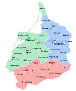
Regierungsbezirk Allenstein was a Regierungsbezirk, or government region, of the Prussian province of East Prussia from 1905 until 1945. The regional capital was Allenstein (present-day Olsztyn). The territory today is part of the Polish Warmian-Masurian Voivodeship.
History
The government region was created on 1 November 1905 as the third East Prussian Regierungsbezirk out of the southern districts of the two original administrative regions Gumbinnen and Königsberg, which had been established in 1815. It comprised the south of the former Duchy of Prussia; the lands of the Allenstein and Rößel districts had belonged to the Prince-Bishopric of Warmia, annexed by Prussia in 1772. In the 1920 East Prussian plebiscite all the Allenstein Region plus the District of Oletzko was part of the Allenstein Plebiscite precinct, with the electorate voting for remaining with Germany by more than 97%.
In 1945 following World War II, Regierungsbezirk Allenstein was dissolved when East Prussia was partitioned between the Republic of Poland and the Soviet Union (Kaliningrad Oblast) according to the resolutions at the Potsdam Conference.
Demographics
The Allenstein region was ethnically mixed in 1910, with German, Polish and Masurian speakers.
| 1910 census | Population | German | Masurian | Polish | Bilingual | ||||
|---|---|---|---|---|---|---|---|---|---|
| Allenstein Region | 543,469 | 274,320 | 50.48% | 175,016 | 32.20% | 73,154 | 13.46% | 19,532 | 3.59% |
| Allenstein Urban | 33,077 | 29,344 | 88.71% | 99 | 0.30% | 2,249 | 6.80% | 1,325 | 4.01% |
| Allenstein Rural | 57,919 | 22,825 | 39.41% | 520 | 0.90% | 32,766 | 56.57% | 1,782 | 3.08% |
| Johannisburg | 51,399 | 16,379 | 31.87% | 29,141 | 56.70% | 4,203 | 8.18% | 1,620 | 3.15% |
| Lötzen | 41,209 | 26,352 | 63.95% | 11,412 | 27.69% | 1,595 | 3.87% | 1,802 | 4.37% |
| Lyck | 55,579 | 27,138 | 48.83% | 19,407 | 34.92% | 6,348 | 11.42% | 2,590 | 4.66% |
| Neidenburg | 59,416 | 20,871 | 35.13% | 25,150 | 42.33% | 10,462 | 17.61% | 2,645 | 4.45% |
| Ortelsburg | 69,935 | 20,218 | 28.91% | 43,513 | 62.22% | 3,390 | 4.85% | 2,463 | 3.52% |
| Osterode | 74,666 | 43,508 | 58.27% | 26,695 | 35.75% | 2,130 | 2.85% | 2,279 | 3.05% |
| Rössel | 50,472 | 43,189 | 85.57% | 48 | 0.10% | 6,512 | 12.90% | 723 | 1.42% |
| Sensburg | 50,097 | 24,496 | 48.90% | 19,031 | 37.99% | 3,499 | 6.98% | 2,310 | 4.61% |
Districts

As of 31 December 1937:
| District | Capital (present name) | Area | Population |
|---|---|---|---|
| Allenstein, urban district | (Olsztyn) | 52 km2 (20 sq mi) | 46,513 (1939) |
| Allenstein, rural district | Allenstein (Olsztyn) | 1,302.58 km2 (502.93 sq mi) | 57,077 (1939) |
| Johannisburg | Johannisburg in East Prussia (Pisz)[2] | 1,684 km2 (650 sq mi) | 52,672 (1939) |
| Lötzen | Lötzen (Giżycko)[3] | 898.8 km2 (347.0 sq mi) | 47,681 (1939) |
| Lyck | Lyck (Ełk) | 1,114 km2 (430 sq mi) | 56,129 (1939) |
| Neidenburg | Neidenburg (Nidzica)[4] | 1,157 km2 (447 sq mi) | 39,486 (1939) |
| Ortelsburg | Ortelsburg (Szczytno) | 1,703 km2 (658 sq mi) | 72,146 (1939) |
| Osterode in East Prussia | Osterode in East Prussia (Ostróda) | 1,551 km2 (599 sq mi) | 75,879 (1939) |
| Rößel | Bischofsburg (Biskupiec) | 853 km2 (329 sq mi) | 51,086 (1939) |
| Sensburg | Sensburg (Mrągowo)[5] | 1,234 km2 (476 sq mi) | 52,746 (1939) |
| total | Allenstein | 11,547 km2 (4,458 sq mi) | 568,024 |
Notes
- ^ Spett, Jakob (1910). "Nationalitätenkarte der östlichen Provinzen des Deutschen Reiches nach dem Ergebnissen der amtlichen Volkszählung vom Jahre 1910 entworfen von Ing. Jakob Spett". 1781-Iv.c. Justus Perthes.
- ^ Jańsbork between 1945-1946.
- ^ Lec between 1945-1946.
- ^ Nibork between 1945-1946.
- ^ Żądźbork between 1945-1947.
53°45′N 20°30′E / 53.75°N 20.5°E
| Authority control databases: National |
|---|