
Aïn Defla
عين الدفلى | |
|---|---|
| Commune of Aïn Defla | |
 | |
 Coat of arms | |
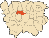
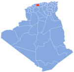
 Aïn Defla Location of Aïn Defla within Algeria | |
| Coordinates: 36°15′55″N 1°58′13″E / 36.2652°N 1.9703°E | |
| Country | |
| Province | Aïn Defla (seat) |
| District | Aïn Defla (coextensive) |
| Government | |
| • PMA Seats | 11 |
| Elevation | 980 m (3,220 ft) |
| Population (2008) | |
| • Total | 65,453 |
| Time zone | UTC+01 (CET) |
| Postal code | 44000 |
| ONS code | 4401 |
| Climate | Csa |
Aïn Defla (Arabic: عين الدفلى, lit. oleander spring) is the capital city of Aïn Defla Province, Algeria. It is also a commune.[1]
YouTube Encyclopedic
-
1/1Views:2 267
-
Vlog | ain defla, Tissemsilt (jour 2 أسوأ نهار)
Transcription
History
In Roman times the city was called Oppidum Novum. The vestiges of the Oppidum Novum are still visible.
The current city was founded in the 20th century by a soldier named youcef afg of the rank of agha, with the idea of bringing together the indigenous populations from the villages of the region.
This region of uneven terrain, which was considered unstable and dangerous by the French during the Algerian War, had for this reason been declared a forbidden zone.
In the 1990s, the same region was a stronghold of the Armed Islamic Group (GIA).[2] There was fighting between militants and government troops in January 2021.[3]
Geography
Climate
| Climate data for Aïn Defla | |||||||||||||
|---|---|---|---|---|---|---|---|---|---|---|---|---|---|
| Month | Jan | Feb | Mar | Apr | May | Jun | Jul | Aug | Sep | Oct | Nov | Dec | Year |
| Mean daily maximum °C (°F) | 13.5 (56.3) |
14.2 (57.6) |
17.7 (63.9) |
20.8 (69.4) |
24.7 (76.5) |
30.3 (86.5) |
34.6 (94.3) |
34.3 (93.7) |
29.2 (84.6) |
25.0 (77.0) |
17.6 (63.7) |
14.5 (58.1) |
23.0 (73.5) |
| Daily mean °C (°F) | 8.5 (47.3) |
9.0 (48.2) |
12.0 (53.6) |
14.8 (58.6) |
18.6 (65.5) |
23.5 (74.3) |
27.3 (81.1) |
27.1 (80.8) |
22.8 (73.0) |
19.0 (66.2) |
12.7 (54.9) |
9.6 (49.3) |
17.1 (62.7) |
| Mean daily minimum °C (°F) | 4.1 (39.4) |
4.3 (39.7) |
6.9 (44.4) |
9.3 (48.7) |
12.7 (54.9) |
16.8 (62.2) |
20.3 (68.5) |
20.7 (69.3) |
17.4 (63.3) |
13.8 (56.8) |
8.5 (47.3) |
5.6 (42.1) |
11.7 (53.1) |
| Average precipitation mm (inches) | 66 (2.6) |
60 (2.4) |
67 (2.6) |
62 (2.4) |
48 (1.9) |
10 (0.4) |
4 (0.2) |
10 (0.4) |
32 (1.3) |
42 (1.7) |
68 (2.7) |
58 (2.3) |
527 (20.9) |
| Average precipitation days | 7 | 7 | 7 | 6 | 5 | 2 | 1 | 2 | 4 | 5 | 7 | 7 | 60 |
| Average relative humidity (%) | 75 | 73 | 68 | 64 | 60 | 50 | 46 | 45 | 58 | 62 | 72 | 75 | 62 |
| Source: Climate data.org(1991-2021)[4] | |||||||||||||
References
- ^ Répartition de la population résidente des ménages ordinaires et collectifs,selon la commune de résidence et la dispersion.
- ^ Au moins 11 soldats algériens tués par des islamistes.
- ^ Chikhi, Lamine (February 2, 2021). "In Algerian mountains, army operation shows persistent militant threat". news.yahoo.com. Reuters. Retrieved February 2, 2021.
- ^ "Aïn Defla Climate: Temperature & Weather by month". Climate data. Retrieved 2023-07-28.

| International | |
|---|---|
| National | |
This article about a location in Aïn Defla Province is a stub. You can help Wikipedia by expanding it. |