
Čierna nad Tisou
Tiszacsernyő | |
|---|---|
Town | |
 Pionierov Square | |
 Coat of arms | |
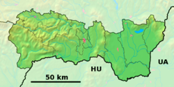 Čierna nad Tisou Location of Čierna nad Tisou within Košice Region  Čierna nad Tisou Location of Čierna nad Tisou within Slovakia | |
| Coordinates: 48°25′00″N 22°05′47″E / 48.41667°N 22.09639°E | |
| Country | Slovakia |
| Region | Košice |
| District | Trebišov |
| First mentioned | 1828 |
| Government | |
| • Mayor | Ing. Viktor Palko MBA (2022-present) |
| Area | |
| • Total | 9.37 km2 (3.62 sq mi) |
| (2022) | |
| Elevation | 110[2] m (360[2] ft) |
| Population | |
| • Total | 3,441 |
| • Density | 370/km2 (950/sq mi) |
| Time zone | UTC+1 (CET) |
| • Summer (DST) | UTC+2 (CEST) |
| Postal code | 076 43[2] |
| Area code | +421 56[2] |
| Car plate | TV |
| Website | www.ciernanadtisou.sk |
Čierna nad Tisou (Hungarian: Tiszacsernyő) is a town and municipality in the Trebišov District in the Košice Region of extreme south-eastern Slovakia, near the Tisa (Tisza) river.
YouTube Encyclopedic
-
1/3Views:3 5054 7472 094
-
Čierna nad Tisou v roku (1975)
-
Vlaky Čierná nad Tisou (SK) 16.7.2015 [FullHD]
-
Čierna nad Tisou 4 ročník fašiangovej súťaže vo výrobe klobás so skupinou DRIŠĽAK
Transcription
History
The town and municipality is one of the newest in the Košice Region established in 1828.
In 1968, from 29 July to 1 August, Soviet and Czechoslovak leaders Leonid Brezhnev and Alexander Dubček met in Čierna nad Tisou. This meeting was followed by the Warsaw Pact invasion of Czechoslovakia on 20 August 1968.
Geography
The town lies at an altitude of 102 metres (335 feet) and covers an area of 9.37 square kilometres (3.62 square miles). It has a population of about 3,500 people. It is close to the tripoint between Hungary, Ukraine and Slovakia.
Ethnicity
The town is about 60% Hungarian, 34% Slovak, 6% Ukrainian.
Economy and facilities
The town has a pharmacy, and outpatient health facilities of a general practitioner and children and adolescents. The town has a public library, gymnasium, a post office, and a number of general and food stores.
Transport

The town has a railway border crossing to Ukraine, where all trains have to change gauge. With 916 tracks this town is the biggest "harbour on land" in Central Europe. The first town across the border in Ukraine is Chop.
Twin towns – sister cities
Čierna nad Tisou is twinned with:
See also
References
- ^ Statistical Office of the Slovak Republic (www.statistics.sk). "Hustota obyvateľstva - obce". www.statistics.sk. Retrieved 8 February 2024.
- ^ a b c d "Základná charakteristika". www.statistics.sk (in Slovak). Statistical Office of the Slovak Republic. 17 April 2015. Retrieved 31 March 2022.
- ^ Statistical Office of the Slovak Republic (www.statistics.sk). "Počet obyvateľov podľa pohlavia - obce (ročne)". www.statistics.sk. Retrieved 8 February 2024.
Genealogical resources
The records for genealogical research are available at the state archive "Statny Archiv in Kosice, Slovakia"
- Roman Catholic church records (births/marriages/deaths): 1719-1922 (parish B)
- Greek Catholic church records (births/marriages/deaths): 1795-1905 (parish B)
- Reformated church records (births/marriages/deaths): 1772-1889 (parish B)
External links
This article relating to the geography of the Trebišov District is a stub. You can help Wikipedia by expanding it. |