
Vitorchiano | |
|---|---|
| Comune di Vitorchiano | |
 | |
Location of Vitorchiano  | |
 Vitorchiano Location of Vitorchiano in Italy  Vitorchiano Vitorchiano (Lazio) | |
| Coordinates: 42°27′N 12°10′E / 42.450°N 12.167°E | |
| Country | Italy |
| Region | Lazio |
| Province | Province of Viterbo (VT) |
| Area | |
| • Total | 29.8 km2 (11.5 sq mi) |
| Elevation | 285 m (935 ft) |
| Population (Dec. 2004)[2] | |
| • Total | 3,690 |
| • Density | 120/km2 (320/sq mi) |
| Time zone | UTC+1 (CET) |
| • Summer (DST) | UTC+2 (CEST) |
| Postal code | 01030 |
| Dialing code | 0761 |
| Website | Official website |
Vitorchiano is a comune (municipality) in the Province of Viterbo in the Italian region of Latium, located about 70 kilometres (43 mi) northwest of Rome and about 7 kilometres (4 mi) northeast of Viterbo. As of 31 December 2004, it had a population of 3,690 and an area of 29.8 square kilometres (11.5 sq mi).[3]

Vitorchiano borders the following municipalities: Bomarzo, Soriano nel Cimino, Viterbo. It is one of I Borghi più belli d'Italia ("The most beautiful villages of Italy").[4]
YouTube Encyclopedic
-
1/3Views:3 7333 8465 824
-
Vitorchiano (VT) - Borghi d'Italia (Tv2000)
-
Borgo di Vitorchiano-drone
-
Vitorchiano (VT) un borgo nel Lazio
Transcription
Main sights
Among the religious architecture in the town are the following:[5]
- Sant'Antonio di Padova – a Neoclassic-style church built in 1793, adjacent to a Franciscan order convent
- Convent of Sant'Agnese – a former convent and church
- Sanctuary of San Michele Arcangelo – a 14th-century oratory
- San Pietro – a Romanesque-style church with decorated portal
- Santissima Trinità – a 14th-century church
- Santa Maria Assunta in Cielo – a 13th-century Romanesque-style church
- Madonna di San Nicola – a 15th-century church with frescoed walls and ceilings
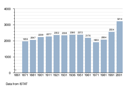
Demographic evolution
References
- ^ "Superficie di Comuni Province e Regioni italiane al 9 ottobre 2011". Italian National Institute of Statistics. Retrieved 16 March 2019.
- ^ "Popolazione Residente al 1° Gennaio 2018". Italian National Institute of Statistics. Retrieved 16 March 2019.
- ^ All demographics and other statistics: Italian statistical institute Istat.
- ^ "Lazio" (in Italian). Retrieved 1 August 2023.
- ^ Tourism information from Comune of Vitorchiano.
External links
This Lazio location article is a stub. You can help Wikipedia by expanding it. |