
Ulrichstein | |
|---|---|
 The castle | |
 Coat of arms | |
Location of Ulrichstein within Vogelsbergkreis district 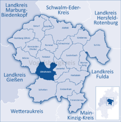 | |
 Ulrichstein  Ulrichstein | |
| Coordinates: 50°35′N 09°12′E / 50.583°N 9.200°E | |
| Country | Germany |
| State | Hesse |
| Admin. region | Gießen |
| District | Vogelsbergkreis |
| Government | |
| • Mayor (2017–23) | Edwin Schneider[1] (Ind.) |
| Area | |
| • Total | 65.61 km2 (25.33 sq mi) |
| Elevation | 614 m (2,014 ft) |
| Population (2022-12-31)[2] | |
| • Total | 3,028 |
| • Density | 46/km2 (120/sq mi) |
| Time zone | UTC+01:00 (CET) |
| • Summer (DST) | UTC+02:00 (CEST) |
| Postal codes | 35327 |
| Dialling codes | 06645 |
| Vehicle registration | VB |
| Website | www.ulrichstein.de |
Ulrichstein (German pronunciation: [ˈʊlʁɪçˌʃtaɪ̯n] ⓘ) is a small town in the Vogelsbergkreis in Hesse, Germany.
YouTube Encyclopedic
-
1/4Views:5961 1073 3907 180
-
Ulrichstein
-
Camperplaats Ulrichstein
-
Ulrichstein im Vogelsberg
-
Leni & Toni CHECK: Reisemobilstellplatz Panoramablick in Ulrichstein | Vogelsberg
Transcription
Geography
Location
Ulrichstein lies in the Vogelsberg Mountains 500 m above sea level and is thereby Hesse's highest town.[3] It is a recognized state-approved climatic spa and lies near the High Hoherodskopf nature reserve
Northeast of town is the source of the river Ohm, the "Omquelle"[4]

Neighboring communities
Ulrichstein borders in the north on the community of Feldatal, in the east on the community of Lautertal, in the south on the town of Schotten, in the southwest on the town of Laubach (Gießen district), and in the west on the community of Mücke.
Constituent communities
In 1972, the town of Ulrichstein and the communities of Kölzenhain, Feldkrücken and Rebgeshain from the Lauterbach district, along with the communities of Bobenhausen, Helpershain, Ober-Seibertenrod, Unter-Seibertenrod and Wohnfeld from the Alsfeld district merged into a new municipality, today's town of Ulrichstein.
References
- ^ "Ergebnisse der letzten Direktwahl aller hessischen Landkreise und Gemeinden" (XLS) (in German). Hessisches Statistisches Landesamt. 5 September 2022.
- ^ "Bevölkerung in Hessen am 31.12.2022 nach Gemeinden" (XLS) (in German). Hessisches Statistisches Landesamt. June 2023.
- ^ "Ulrichstein - Geopark Vogelsberg". www.geopark-vogelsberg.de. Retrieved 2023-01-27.
- ^ "Ulrichstein - Die Ohmquelle". www.ulrichstein.de (in German). Retrieved 2023-01-27.
External links
Towns and municipalities in Vogelsberg (district) | ||
|---|---|---|
| International | |
|---|---|
| National | |
| Geographic | |