
Boikivske Raion
Бойківський район | |
|---|---|
 Flag  Coat of arms | |
 | |
| Country | |
| Region | Donetsk Oblast |
| Established | 1934 |
| Disestablished | 18 July 2020 |
| Admin. center | Boikivske (de jure) Myrne (de facto, 2014–2020)[1][2] |
| Subdivisions | List
|
| Government | |
| • Governor | Olga Afenkina |
| Area | |
| • Total | 812.92 km2 (313.87 sq mi) |
| Population (2020) | |
| • Total | |
| Time zone | UTC+02:00 (EET) |
| • Summer (DST) | UTC+03:00 (EEST) |
| Postal index | 87100-87182 |
| Area code | +380 6279 |
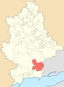
Boikivske Raion (Ukrainian: Бойківський район) or Telmanove Raion (Ukrainian: Тельманівський район, romanized: Telmanivskyi raion) was one of the administrative raions (a district) of Donetsk Oblast, Ukraine from 1934 until 2020. The administrative center of the raion was located in the urban-type settlement of Boikivske, also known as Telmanove. The last estimate of the raion population, reported by the Ukrainian government, was 13,773 (2020 est.).[3]
Since 2014, much of the area of the raion has been controlled by the Donetsk People's Republic (DPR), a Russia-supported breakaway state (later explicitly and illegally annexed by Russia).[4]
History
20th century
The raion was originally formed as Ostheim Raion in late 1934, with Ostheim (now Boikivske) as its center.[5] In 1935, the raion was renamed Telmanove Raion after the German Communist leader Ernst Thälmann. As the result of the 1951 Polish–Soviet territorial exchange, the Soviet authorities deported and resettled approximately 400 families of Boykos from the village of Chorna (today Czarna in Poland), the former Nyzhni Ustryky Raion of Drohobych Oblast that was transferred to Poland.[citation needed]
21st century
In 2014, the pro-Russian militant group known as the Donetsk People's Republic (DPR) seized almost all of Telmanove Raion, along with other parts of Donetsk Oblast and Luhansk Oblast, beginning the war in Donbas. On 9 December 2014, the Verkhovna Rada, Ukraine's national parliament, moved the raion's administration and headquarters to Myrne, a town in Telmanove Raion which remained under government control. The boundaries of Telmanove Raion were also adjusted, changing its total area to 812.92 km2 (313.87 sq mi).[1][2] This was due to the fact that a small part of the raion on the west bank of the Kalmius river was under Ukrainian army control, and had been effectively severed from the rest of the raion by the frontline of the war, severely hindering the administration of the villages in that area. To fix this problem, the Ukrainian government transferred government-controlled land to Volnovakha Raion, so that the reduced area of the raion was entirely under control of the pro-Russian militants. The transferred localities included the towns Andriivka and Myrne, among other smaller settlements.[6]
In 2016, Ukraine's national parliament, the Verkhovna Rada, renamed Telmanove Raion to Boikivske Raion and Telmanove to Boikivske.[7] The town's name change was done in commemoration of the Boykos people who were deported there in the 1950s.[8]
The raion was officially abolished on 18 July 2020 as part of the administrative reform of Ukraine, which reduced the number of raions of Donetsk Oblast to eight.[9][10] The area of Boikivske Raion was merged into the newly created Kalmiuske Raion.[11] The DPR has continued using the raion - as "Telmanove Raion" - as one of its administrative units.[4]
Geography
Telmanove Raion bordered Novoazovsk Raion to its south, Nikolske Raion to its southwest, Volnovakha Raion to its west, Starobesheve Raion to its north. From the east, the raion was bounded by the international Russia–Ukraine border.[citation needed]
Administrative divisions
The district is divided into three settlement councils and twelve rural councils.[citation needed]
Demographics
According to the 2001 Ukrainian Census:[12]
| Ethnicity | ||
| Ukrainians | 20,442 | 57.8% |
| Russians | 7,359 | 20.8% |
| Greeks (Urums) | 6,172 | 17.5% |
| Tatars | 623 | 1.8% |
| Belarusians | 165 | 0.5% |
| Germans | 152 | 0.4% |
Gallery
-
 Monument in Konkove (25th Anniversary of Donbas liberation from Nazi invaders)
 -
 Landscape of the Kalmius Reserve
 -
 Kalmius River at the Kalmius Reserve
References
- ^ a b Laws of Ukraine. Verkhovna Rada of Ukraine No. 32-VIII: Про зміни в адміністративно-територіальному устрої Донецької області, зміну і встановлення меж Волноваського, Новоазовського та Тельманівського районів Донецької області (On the changes in the administrative and territorial structure of Donetsk Oblast, changing and defining the boundaries of the Volnovakha, Novoazovsk and Telmanove Raions of Donetsk Oblast). Adopted on 11 December 2014. (Ukrainian)
- ^ a b "In the Donetsk Oblast three district centers removed from the territory seized by militants". Ukrayinska Pravda (in Ukrainian). 8 December 2014. Retrieved 31 December 2014.
- ^ Чисельність наявного населення України на 1 січня 2020 року / Population of Ukraine Number of Existing as of January 1, 2020 (PDF) (in Ukrainian and English). Kyiv: State Statistics Service of Ukraine. Archived (PDF) from the original on 28 September 2023.
- ^ a b "Мероприятия, запланированные на 2020 год в сферах жилищно-коммунального хозяйства и строительства" (in Russian). Donetsk People's Republic.
- ^ "Тельманове, Тельманівський район, Донецька область". Історія міст і сіл Української РСР (in Ukrainian). Retrieved 2023-11-05.
- ^ "Про зміни в адміністративно-територіальному устрої Донецької області, зміну і встановлення меж міста Маріуполь, Волноваського, Новоазовського та Тельманівського районів Донецької області". Офіційний вебпортал парламенту України (in Ukrainian). Retrieved 2023-12-25.
- ^ "Про перейменування окремих населених пунктів та районів на тимчасово окупованих територіях Донецької та Луганської областей". Retrieved 2023-12-25.
- ^ "Ukraine's New York: child of a tragic love story of European industrialists and Donbas". 2021-07-03. Retrieved 2023-12-26.
- ^ "Про утворення та ліквідацію районів. Постанова Верховної Ради України № 807-ІХ". Голос України (in Ukrainian). 2020-07-18. Retrieved 2020-10-03.
- ^ "Нові райони: карти + склад" (in Ukrainian). Міністерство розвитку громад та територій України.
- ^ "Про утворення та ліквідацію районів". Офіційний вебпортал парламенту України (in Ukrainian). Retrieved 2023-11-07.
- ^ "Національний склад та рідна мова населення Донецької області" [Ethnic and linguistic composition of Donetsk Oblast] (in Ukrainian). Archived from the original on 7 February 2012.
47°32′N 37°46′E / 47.533°N 37.767°E
This article about a location in Donetsk Oblast is a stub. You can help Wikipedia by expanding it. |