
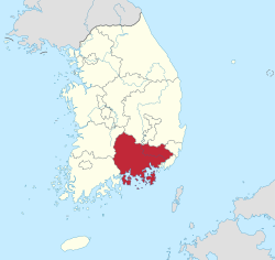
South Gyeongsang Province
경상남도 | |
|---|---|
| Korean transcription(s) | |
| • Hangul | 경상남도 |
| • Hanja | 慶尙南道 |
| • McCune‑Reischauer | Kyŏngsang-namdo |
| • Revised Romanization | Gyeongsangnam-do |
 Flag  Logo | |
 | |
| Coordinates: 35°15′N 128°15′E / 35.250°N 128.250°E | |
| Country | South Korea |
| Region | Yeongnam |
| Capital | Changwon |
| Subdivisions | 8 cities; 10 counties |
| Government | |
| • Governor | Park Wan-su (People Power) |
| Area | |
| • Total | 10,533 km2 (4,067 sq mi) |
| • Rank | 4th |
| Population (December, 2018) | |
| • Total | 3,447,687 |
| • Rank | 2nd |
| • Density | 327.86/km2 (849.2/sq mi) |
| Demonym | Gyeongnamian |
| Metropolitan Symbols | |
| • Flower | Rose |
| • Tree | Zelkova |
| • Bird | White heron |
| GDP | |
| • Total | KR₩ 120 trillion US$ 96 billion (2022) |
| ISO 3166 code | KR-48 |
| Dialect | Gyeongsang |
| Website | Official website (English) |


South Gyeongsang Province (Korean: 경상남도, romanized: Gyeongsangnam-do, Korean pronunciation: [kjʌŋ.saŋ.nam.do]) is a province in the southeast of South Korea. The provincial capital is at Changwon. It is adjacent to the major metropolitan center and port of Busan. The UNESCO World Heritage Site Haeinsa, a Buddhist temple that houses the Tripitaka Koreana and tourist attraction, is located in this province. Automobile and petrochemical factories are largely concentrated along the southern part of the province, extending from Ulsan through Busan, Changwon, and Jinju.
YouTube Encyclopedic
-
1/4Views:7 8985 014 70980637 334
-
Dongpirang Village Vacation Travel Guide | Expedia
-
11 Things NOT to do in South Korea - MUST SEE BEFORE YOU GO!
-
NATURE TRIP I YELLOW COSMOS in GYEONGSANGBUK-DO GUMI I BEGINNING OF SUMMER
-
Daegu- the 4th largest city in South Korea | Cinematic Aerial View | 대구시, 대한민국 2019 【4K】
Transcription
Etymology
The name derives from Korean Gyeongsang 'joyous furthermore'; from gyeong (Korean 경, Hanja 慶) 'celebrate', and sang (Korean 상, Hanja 尚) 'append to'. The name derives from the names of the principal cities of Gyeongju (경주; 慶州) and Sangju (상주; 尙州).
History
Joseon
In 1407, for military purposes, the administrative districts were reorganized, with Gyeongsang-do being divided into Gyeongsangjwa-do (or Gyeongsangjwa Province; left) and Gyeongsangwu-do (or Gyeongsangwu Province; right) as the reference points of the Nakdonggang River.[2]
Before 1895, the area corresponding to modern-day South Gyeongsang Province was part of Gyeongsang Province, one of the Eight Provinces of Korea during the Joseon dynastic kingdom. In 1895, southern Gyeongsang was replaced by the districts of Jinju in the west and Dongnae (modern-day Busan) in the east. In 1896, they were merged to form South Gyeongsang Province.
Today
The provincial capital was originally at Jinju; it moved in 1925 to Busan. During the Japanese rule over Korea, the province was known as Keishōnan-dō. In 1948, South Gyeongsang Province became part of South Korea. In 1963, Pusan separated from South Gyeongsang Province to become a Directly Governed City (Jikhalsi). In 1983, the provincial capital moved from Pusan to Changwon. In 1995, Pusan became a Metropolitan City (Gwangyeoksi), and Ulsan separated from South Gyeongsang Province to become a Metropolitan City in 1997.
Geography
The province is part of the Yeongnam region, on the north by North Gyeongsang Province, on the west by North Jeolla Province and South Jeolla Province, and on the south by the Korea Strait far from Nagasaki Prefecture, Japan. Most of the province is drained by the Nakdong River and its tributaries. The total area of the province is 10,533 square kilometres (4,067 sq mi).[3]
The tail of the Taebaek Mountains reaches the east of the Province, and the Nakdonggang River flows in the middle of the mountain range. The Province is bordered by the Sobaek Mountains and Honam to the west. The central lowland spreads along the Nakdonggang River basin. The Nakdonggang River is collecting tributaries of Gyeongsangnam-do to develop the Gimhae Delta Plain near the downstream. Jirisan, Deogyusan, and Bagunsan are lined up in the west.[4]
Demographics
| Year | Pop. | ±% p.a. |
|---|---|---|
| 1980 | 2,689,376 | — |
| 1990 | 2,810,194 | +0.44% |
| 2000 | 2,978,502 | +0.58% |
| 2010 | 3,160,154 | +0.59% |
| 2015 | 3,334,524 | +1.08% |
| 2020 | 3,333,056 | −0.01% |
| Source: Citypopulation[5] | ||
Religion in South Gyeongsang (2015)[6]
Resources
The Nakdong delta plain around Gimhae is one of the best granaries in South Korea. Agricultural products form Gyeongsangnam-do include rice, beans, potatoes, and barley. The area is renowned for its cotton, sesame, and fruits which are grown along the southern seaside. A number of marine products are caught. The province is one of the country's leading fisheries.
Major cities
| Rank | Municipal pop. | ||||||||
|---|---|---|---|---|---|---|---|---|---|
 Changwon  Gimhae |
1 | Changwon | 1,029,389 |  Jinju  Yangsan | |||||
| 2 | Gimhae | 552,427 | |||||||
| 3 | Jinju | 352,403 | |||||||
| 4 | Yangsan | 351,206 | |||||||
| 5 | Geoje | 246,965 | |||||||
| 6 | Tongyeong | 127,984 | |||||||
| 7 | Sacheon | 111,184 | |||||||
| 8 | Miryang | 103,228 | |||||||
| 9 | Haman | 65,279 | |||||||
| 10 | Geochang | 59,595 | |||||||
The largest cities in the region are Busan and Ulsan, which are separately administered as provincial-level Metropolitan Cities. Apart from the capital Changwon, other large or notable cities include Gimhae and Jinju.
Attractions

Gyeongsangnam-do is the home of Haeinsa, a Buddhist temple that houses the Tripitaka Koreana and attracts many tourists. It is in the national park around Jirisan (1,915 m) on the border with Jeollabuk-do. The temple was first built in 802.
Changnyeong County contains three major tourist attractions for the province: Upo Wetland, the natural hotsprings of Bugok, and Hwawangsan.
Yangsan-si contains two major temples for the province: Tongdosa and Naewon Temple
Culture
Festival

Beginning in 2002, the Tongyeong International Music Festival is one of the most important music events in Asia. Held every spring, the festival consists of stages from well-known classical music figures and aspiring musicians. It aims to foster young composers and performers.[8]
Jinhae Naval Port Festival, one of the biggest cherry blossom festivals in South Korea, is held in Jinhae.[9]
The Haman Water Fireworks Festival takes place around Buddha's Birthday in April every year. It is one of the cultures that has existed since the Joseon Dynasty. It originated from the heart of praying for peace in the country.[10]
Tourism
The Jinju National Museum opened in 1984 as the first national museum in South Gyeongsang Province. Visitors can experience cultural heritages in the Province, including Gaya.[11]
Haeinsa, one of Korea's top three temples, was built by two monks in 802. The temple houses various treasures along with Woodblocks of national treasures, including the Tripitaka Koreana and Janggyeong Panjeon.[12]
- Destination
-

-

-
 Yeonji Park in Gimhae
Administrative divisions


Gyeongsangnam-do is divided into 8 cities (si) and 10 counties (gun). The names below are given in English, hangul, and hanja.
| Map | # | Name | Hangul | Hanja | Population (2012)[13] | Subdivisions |
|---|---|---|---|---|---|---|

| ||||||
| — Specific City — | ||||||
| 1 | Changwon | 창원시 | 昌原市 | 1,106,081 | 5 ilban-gu — 2 eup, 6 myeon, 54 haengjeong-dong | |
| 2 | Gimhae | 김해시 | 金海市 | 531,383 | 1 eup, 6 myeon, 12 haengjeong-dong | |
| — City — | ||||||
| 3 | Jinju | 진주시 | 晉州市 | 341,221 | 1 eup, 15 myeon, 15 haengjeong-dong | |
| 4 | Yangsan | 양산시 | 梁山市 | 274,770 | 1 eup, 4 myeon, 8 haengjeong-dong | |
| 5 | Geoje | 거제시 | 巨濟市 | 245,972 | 9 myeon, 10 haengjeong-dong | |
| 6 | Tongyeong | 통영시 | 統營市 | 143,039 | 1 eup, 6 myeon, 8 haengjeong-dong | |
| 7 | Sacheon | 사천시 | 泗川市 | 117,968 | 1 eup, 7 myeon, 6 haengjeong-dong | |
| 8 | Miryang | 밀양시 | 密陽市 | 109,967 | 2 eup, 9 myeon, 5 haengjeong-dong | |
| — County — | ||||||
| 9 | Haman County | 함안군 | 咸安郡 | 70,443 | 2 eup, 8 myeon | |
| 10 | Geochang County | 거창군 | 居昌郡 | 63,536 | 1 eup, 11 myeon | |
| 11 | Changnyeong County | 창녕군 | 昌寧郡 | 64,297 | 2 eup, 12 myeon | |
| 12 | Goseong County | 고성군 | 固城郡 | 58,553 | 1 eup, 13 myeon | |
| 13 | Namhae County | 남해군 | 南海郡 | 48,899 | 1 eup, 9 myeon | |
| 14 | Hapcheon County | 합천군 | 陜川郡 | 50,713 | 1 eup, 16 myeon | |
| 15 | Hadong County | 하동군 | 河東郡 | 51,235 | 1 eup, 12 myeon | |
| 16 | Hamyang County | 함양군 | 咸陽郡 | 41,155 | 1 eup, 10 myeon | |
| 17 | Sancheong County | 산청군 | 山淸郡 | 36,079 | 1 eup, 10 myeon | |
| 18 | Uiryeong County | 의령군 | 宜寧郡 | 31,027 | 1 eup, 12 myeon | |
Government
Government Complex South Gyeongsang Province

Gyeongnam Regional Government Complex was built to integrate government agencies in Changwon and Masan. It was completed in March 2013.[14]
Governor
Sister districts
 Yamaguchi Prefecture (July 26, 1987)
 Kedah (July 3, 1989)
 Maryland (November 18, 1991)
 Shandong (September 8, 1993)
 East Java (May 9, 1996)
 Đồng Nai Province (September 1, 1996)
 Khabarovsk Krai (September 14, 1996)
 Jalisco (March 10, 1997)
 Laguna province (April 15, 1997)
 Pomeranian Voivodeship (April 22, 1997)
 Fejér County (April 24, 1997)
Notable people from South Gyeongsang Province

- Chun Doo-hwan, Former South Korean President
- Kim Young-sam, Former South Korean President
- Roh Moo-hyun, Former South Korean President
- Moon Jae-in, Former South Korean President
- Winter (Kim Min-jeong), a member of K-pop girl group, Aespa
- Koo In-hwoi, South Korean businessman and the founder of LG Group
See also
- Igeum-dong site - complex archaeological site in Sacheon-si
- Gyeongsang National University
- Tongyeong International Music Festival
- North Gyeongsang Province

References
- ^ "2022년 지역소득(잠정)". www.kostat.go.kr.
- ^ "History". South Gyeongsang Province (경상남도).
- ^ 일반 현황 (in Korean). South Gyeongsang Province. Retrieved 18 March 2013.
- ^ "Geographic location". North Gyeongsang Province (경상남도).
- ^ "South Korea: Provinces".
- ^ "2015 Census – Religion Results" (in Korean). KOSIS KOrean Statistical Information Service. Archived from the original on 26 February 2021. Retrieved 10 Mar 2021.
- ^ "South Korea: Provinces".
- ^ "TONGYEONG INTERNATIONAL MUSIC FESTIVAL". Tongyeong International Music Foundation.
- ^ "Cherry blossom festival begins in Jinhae". Korea JoongAng Daily. March 24, 2024.
- ^ "Traditional Festivals". South Gyeongsang Province (경상남도).
- ^ "About the Museum". Jinju National Museum.
- ^ "Hapcheon Haeinsa Temple (해인사 (합천))". Korea Tourism Organization.
- ^ "Population of Gyeongsangnam-do" (in Korean). Gyeongsangnam-do. Archived from the original on 2014-02-25. Retrieved 2013-07-16.
- ^ "Gyeongnam Regional Government Complex". GOVERNMENT BUILDINGS MANAGEMENT OFFICE.
External links
 South Gyeongsang travel guide from Wikivoyage
- Official website (in English)
Places adjacent to South Gyeongsang Province | ||||||||||||||||
|---|---|---|---|---|---|---|---|---|---|---|---|---|---|---|---|---|
| ||||||||||||||||

| International | |
|---|---|
| National | |
| Geographic | |