
San-Pédro | |
|---|---|
City, sub-prefecture, and commune | |
 View to a methodist church in San-Pédro | |
 San-Pédro Location within Ivory Coast 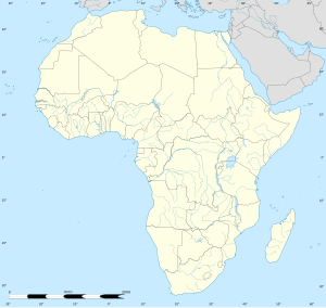 San-Pédro San-Pédro (Africa) | |
| Coordinates: 4°45′N 6°38′W / 4.750°N 6.633°W | |
| Ivory Coast | |
| District | Bas-Sassandra |
| Region | San-Pédro |
| Department | San-Pédro |
| Area | |
| • Total | 887 km2 (342 sq mi) |
| Elevation | 1 m (3 ft) |
| Population (2021 census)[2] | |
| • Total | 390,654 |
| • Density | 440/km2 (1,100/sq mi) |
| • City | 164,944 [1] |
| (2014 census) | |
San-Pédro is a city in southwestern Ivory Coast. It is the nation's second largest port and the seat of Bas-Sassandra District and San-Pédro Region. It is also a commune and the seat of and a sub-prefecture of San-Pédro Department. In the 2014 census, the city had a population of 164,944,[1] making it the sixth-largest city in the country. The city is served by San Pédro Airport.
Northwest of the city lies the Taï National Park, known as one of the last sanctuaries of the pygmy hippopotamus, which is listed on the UNESCO's World Heritage List.
YouTube Encyclopedic
-
1/1Views:2 372
-
Ghana vs Ivory Coast vs Senegal (1960 - 2020): GDP Nominal, Per Capita and Population
Transcription
Economy
Largely developed from the 1960s, fishing is an important industry, while the town is known for its nightlife and its beaches.
Demographics
In 2014, the population of the sub-prefecture of San-Pédro was 261,616.[3]
Transport
A railway is proposed from San-Pédro to iron ore deposits around Mount Nimba.[4] There would be no immediate connection with the existing metre gauge national railway at Abidjan.
Education
École française de San Pédro is located in San-Pédro.
Notable people
- Jean-Philippe Gbamin (born 25 September 1995), is an Ivorian footballer
Villages
The twenty eight villages of the sub-prefecture of San-Pédro and their population in 2014 are:[3]
- Baba (8,336)
- Digboué (138)
- Dimoulé (1,068)
- Djiro-Gnépahio/Campement Bernard (3,563)
- Grand-Gabo (116)
- Kablaké 1 (471)
- Kablaké 2 (468)
- Klou (220)
- Petit-Gabo (240)
- Petit-Pédro (2,711)
- Pont-Bascule (914)
- Poro (932)
- San-Pedro (164,944)
- Taki (1,502)
- Digboué-Klou (211)
- Djahio (1,996)
- Doulayéko (1,957)
- Goréké (873)
- Kounouko (7,885)
- Kpotè (7,037)
- Krémoué (1,587)
- Madié (830)
- Magné (1,059)
- Mapri (1,204)
- Marikro (3,481)
- Monogaga (511)
- Moussadougou (16,344)
- Podio (1,553)
- Pont-Brimé (3,449)
- Popoko (2,382)
- Taboké (2,865)
- Watté (20,769)
Gallery


See also
References
- ^ a b "Ivory Coast: Districts, Major Cities & Localities - Population Statistics, Maps, Charts, Weather and Web Information". City Population. 2022-08-08. Archived from the original on Dec 4, 2023.
- ^ Citypopulation.de Population of regions and sub-prefectures of Ivory Coast
- ^ a b "RGPH 2014, Répertoire des localités, Région San-Pédro" (PDF). ins.ci. Retrieved 5 August 2019.
- ^ "WorldOfRail.com".[dead link]
Regional seat: San-Pédro | ||
| San-Pédro Department |  | |
| Tabou Department | ||
* also a commune | ||
| International | |
|---|---|
| National | |