
Prineville Lake Acres, Oregon | |
|---|---|
 Prineville Lake Acres  Prineville Lake Acres | |
| Coordinates: 44°10′5″N 120°47′23″W / 44.16806°N 120.78972°W | |
| Country | United States |
| State | Oregon |
| County | Crook |
| Area | |
| • Total | 6.59 sq mi (17.07 km2) |
| • Land | 6.59 sq mi (17.07 km2) |
| • Water | 0.00 sq mi (0.00 km2) |
| Elevation | 3,820 ft (1,160 m) |
| Population | |
| • Total | 1,556 |
| • Density | 236.04/sq mi (91.14/km2) |
| Time zone | UTC-8 (Pacific (PST)) |
| • Summer (DST) | UTC-7 (PDT) |
| ZIP Code | 97754 (Prineville) |
| Area code(s) | 541/458 |
| FIPS code | 41-59916 |
| GNIS feature ID | 2812878[3] |
Prineville Lake Acres is a census-designated place (CDP) in Crook County, Oregon, United States. It was first listed as a CDP prior to the 2020 census.[3]
The CDP is in western Crook County, 12 miles (19 km) southeast of Prineville, the county seat. It is surrounded by the Juniper Canyon CDP.
Demographics
| Census | Pop. | Note | %± |
|---|---|---|---|
| 2020 | 1,556 | — | |
| U.S. Decennial Census[4][2] | |||
References
- ^ "ArcGIS REST Services Directory". United States Census Bureau. Retrieved October 12, 2022.
- ^ a b "Census Population API". United States Census Bureau. Retrieved October 12, 2022.
- ^ a b "Prineville Lake Acres Census Designated Place". Geographic Names Information System. United States Geological Survey, United States Department of the Interior.
- ^ "Census of Population and Housing". Census.gov. Retrieved June 4, 2016.
Municipalities and communities of Crook County, Oregon, United States | ||
|---|---|---|
| City | 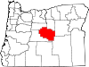 | |
| CDPs | ||
| Other communities | ||
This Crook County, Oregon state location article is a stub. You can help Wikipedia by expanding it. |