
 Prince of Wales Island, Nunavut. | |
 | |
| Geography | |
|---|---|
| Location | Northern Canada |
| Coordinates | 72°40′N 99°00′W / 72.667°N 99.000°W |
| Archipelago | Arctic Archipelago |
| Area | 33,339 km2 (12,872 sq mi) |
| Area rank | 40th |
| Highest elevation | 424 m (1391 ft) |
| Highest point | 73°48′26″N 97°50′14″W / 73.80722°N 97.83722°W |
| Administration | |
Canada | |
| Territory | Nunavut |
| Demographics | |
| Population | Uninhabited |


Prince of Wales Island (French: Île du Prince-de-Galles) is an Arctic island in Nunavut, Canada. One of the larger members of the Arctic Archipelago, it lies between Victoria Island and Somerset Island and is south of the Queen Elizabeth Islands.
For administrative purposes, it is divided between Qikiqtaaluk and Kitikmeot regions. There are no permanent settlements on the island.
YouTube Encyclopedic
-
1/5Views:846694 1992 880521771
-
08 11 SUAANGAN Banks Island Signs of Global Warming
-
THE WHALE HUNTERS
-
4. In Search of Franklin - PLANE DOWN - Episode 4 - EMERGENCY LANDING, polar bear comes too close.
-
Roger Hitkolok - Sutton Island
-
Australian States vs Canadian Provinces, GDP Comparison 1960-2025 (in Billions of US Dollars)
Transcription
Geography

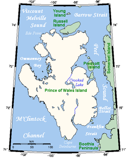
It is a low tundra-covered island with an irregular coastline deeply indented by Ommanney Bay in the west and Browne Bay in the east. Ommanney Bay is named after Admiral Sir Erasmus Ommanney of the Royal Navy who explored the area as part of the search for the Franklin Expedition.
Its area has been estimated at 33,339 km2 (12,872 sq mi). Prince of Wales Island is the world's 40th largest island and the 10th largest in Canada. Its highest known point—with an elevation of 424 m (1,391 ft)—is an unnamed spot at 73°48′26″N 97°50′14″W / 73.80722°N 97.83722°W in the island's far northeastern end,[1] overlooking the Baring Channel, which separates the island from nearby Russell Island.
History

Its European discovery came in 1851 by Francis Leopold McClintock's sledge parties during the searches for John Franklin's last expedition.[2] McClintock, along with Sherard Osborn and William Browne, charted the northern half of the island. Its southern half was charted by Allen Young in 1859.[3] It was named after Albert Edward, eldest son of Queen Victoria, then ten years old and Prince of Wales. He later became King Edward VII.
See also
![]() Islands portal
Islands portal
![]() Geography portal
Geography portal
References
- ^ Peakbagger
- ^ Osborn, Sherard (1852). Stray leaves from an Arctic journal, or, Eighteen months in the polar regions : in search of Sir John Franklin's expedition, in the years 1850–51. New York, NY: Putnam’s.
- ^ Savours, Ann (1999). The Search for the North West Passage. Basingstoke, GB: Palgrave Macmillan. ISBN 978-0312223724.
Further reading
- Blackadar, Robert Gordon; Precambrian Geology of Boothia Peninsula, Somerset Island, and Prince of Wales Island, District of Franklin, Ottawa, ON: Dept. of Energy, Mines and Resources, 1967
- Christie, Robert Loring; Stratigraphic Sections of Palaeozoic Rocks on Prince of Wales and Somerset Island, District of Franklin, Northwest Territories, Ottawa, ON: Queen's Printer, 1967
- Dyke, Arthur S.; Quaternary Geology of Prince of Wales Island, Arctic Canada, Ottawa, ON: Geological Survey of Canada, 1992, ISBN 0-660-14408-5
- Mayr, Ulrich; Geology of eastern Prince of Wales Island and adjacent smaller islands, Nunavut (parts of NTS 68D, Baring Channel and 68A, Fisher Lake), Ottawa, ON: Geological Survey of Canada, 2004, ISBN 0-660-18804-X
External links
 Media related to Prince of Wales Island at Wikimedia Commons
- Prince of Wales Island in the Atlas of Canada - Toporama; Natural Resources Canada
| 100,000 km2 (38,610 sq mi) and greater | ||
|---|---|---|
| 20,000–99,999 km2 (7,722–38,610 sq mi) |
| |
| International | |
|---|---|
| National | |