
Bad Dürkheim | |
|---|---|
 Flag 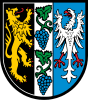 Coat of arms | |
 | |
| Country | Germany |
| State | Rhineland-Palatinate |
| Capital | Bad Dürkheim |
| Government | |
| • District admin. | Hans-Ulrich Ihlenfeld (CDU) |
| Area | |
| • Total | 595 km2 (230 sq mi) |
| Population (31 December 2022)[1] | |
| • Total | 134,546 |
| • Density | 230/km2 (590/sq mi) |
| Time zone | UTC+01:00 (CET) |
| • Summer (DST) | UTC+02:00 (CEST) |
| Vehicle registration | DÜW |
| Website | kreis-bad-duerkheim.de |
Bad Dürkheim (German pronunciation: [ˌbaːt ˈdʏʁkhaɪm])[2] is a district in Rhineland-Palatinate, Germany. It is bounded by (from the west and clockwise) the districts of Kaiserslautern, Donnersbergkreis and Alzey-Worms, the city of Worms, the Rhein-Pfalz-Kreis, the city of Neustadt/Weinstraße, the districts of Südliche Weinstraße, the city of Landau (the Taubensuhl/Fassendeich forest part of the city), the district Südwestpfalz, and the city of Kaiserslautern.
YouTube Encyclopedic
-
1/5Views:6909 6246444 734321
-
Bird's Eye View Of Bad dürkheim, Germany (Europe)/ 4K Drone Footage / Breathtaking View
-
Walking in BAD DÜRKHEIM / Germany 🇩🇪 - Rainy Evening Tour - 4K 60fps (UHD)
-
Walking in the City | Bad Durkheim Germany | Walking virtual tour in Germany | Walking 4K tour
-
Mythen und Legenden - Die Geschichte der Hardenburg - Pfälzerwald - Burgruinen Deutschland
-
Klosterruine Limburg | Bad Dürkheim | Pfälzerwald
Transcription
History
The eastern rim of the Palatinate forest has been densely populated since the Middle Ages. Several medieval castles show the significance of the region during the early Holy Roman Empire.
The district was established in 1969 by combining portions of the former districts of Neustadt and Frankenthal.
Dialect
The dialect of Bad Dürkheim and environs is closer to the Pennsylvania Dutch language—also known as Pennsylvania German or as Deitsch, the native tongue of the Amish and others—than any other dialect of German.[citation needed]
Geography
The district is located on the eastern rim of the Palatinate Forest a line of hills called the Haardt. The German Wine Road (Deutsche Weinstraße), a scenic road along the best vineyards of the Palatinate wine region, runs through the district from north to south. The district is sometimes called "the heart of the Palatinate".
The best wine-growing area is the Mittelhaardt ("Middle Haardt"), where the Riesling wine is cultivated, which is considered to be one of the best German wines.
Coat of arms
The coat of arms displays:
- The heraldic lion of the Palatinate
- Grapes symbolising the Wine Road and the vineyards
- The heraldic eagle of the former county of Leiningen
Towns and municipalities

| Verband-free towns | Verband-free municipality |
|---|---|
| Verbandsgemeinden | ||||
|---|---|---|---|---|
|
|
|
| |
| 1seat of the Verbandsgemeinde; 2town | ||||
References
- ^ "Bevölkerungsstand 2022, Kreise, Gemeinden, Verbandsgemeinden" (PDF) (in German). Statistisches Landesamt Rheinland-Pfalz. 2023.
- ^ "Dürkheim". Duden – Das Aussprachewörterbuch (in German) (7th ed.). Berlin: Bibliographisches Institut. 2015. p. 327. ISBN 978-3411911516.
External links
- Official website (German)
49°30′N 8°10′E / 49.5°N 8.17°E
| International | |
|---|---|
| National | |