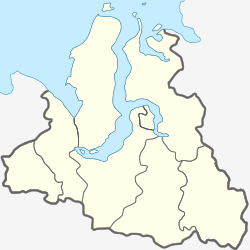
Labytnangi
Лабытнанги | |
|---|---|
 | |
| Coordinates: 66°39′26″N 66°25′06″E / 66.65722°N 66.41833°E | |
| Country | Russia |
| Federal subject | Yamalo-Nenets Autonomous Okrug[1] |
| Founded | 1890[2] |
| Town status since | 1975[2] |
| Government | |
| • Head[2] | Leonid Savchenko[2] |
| Elevation | 10 m (30 ft) |
| Population | |
| • Total | 26,936 |
| • Subordinated to | town of okrug significance of Labytnangi[1] |
| • Capital of | town of okrug significance of Labytnangi[1] |
| • Urban okrug | Labytnangi Urban Okrug[4] |
| • Capital of | Labytnangi Urban Okrug[4] |
| Time zone | UTC+5 (MSK+2 |
| Postal code(s)[6] | |
| OKTMO ID | 71953000001 |
| Website | lbt |
Labytnangi (Russian: Лабытна́нги; from Khanty: лапыт нангк; lit. seven larches; Nenets: Лабытнаӈгы. Labytnaŋgy) is a town in Yamalo-Nenets Autonomous Okrug, Russia, located on the left bank of the Ob River, 20 kilometers (12 mi) northwest of Salekhard. Population: 26,936 (2010 Census);[3] 27,304 (2002 Census);[7] 31,501 (1989 Census).[8]
YouTube Encyclopedic
-
1/3Views:1 4398511 106
-
Train Workuta - Labytnangi departing from km 110
-
Train Workuta - Labytnangi arriving at km 110 (between Sob and Poljarnij Ural)
-
Train Labytnangi - Vorkuta between Sob and Poljarnij Ural
Transcription
History
It was established in 1890.[2] It was granted urban-type settlement status in 1952[citation needed] and town status in 1975.[2]
Labytnangi is connected to the European Russia by a branch of the Konosha-Vorkuta railway. It is the terminus station on this short stub branch; however, it was built in the early 1950s by Gulag inmates as the first stage of a large project under which the railway would have crossed the north of Tyumen Oblast and reached Igarka on the Yenisei River. The project was abandoned after Joseph Stalin's death.[citation needed]
Administrative and municipal status
Within the framework of administrative divisions, it is incorporated as the town of okrug significance of Labytnangi—an administrative unit with the status equal to that of the districts.[1] As a municipal division, the town of okrug significance of Labytnangi is incorporated as Labytnangi Urban Okrug.[4]
References
Notes
- ^ a b c d e Law #42-ZAO
- ^ a b c d e f Official website of Yamalo-Nenets Autonomous Okrug. Information about Labytnangi Archived July 5, 2007, at the Wayback Machine
- ^ a b Russian Federal State Statistics Service (2011). Всероссийская перепись населения 2010 года. Том 1 [2010 All-Russian Population Census, vol. 1]. Всероссийская перепись населения 2010 года [2010 All-Russia Population Census] (in Russian). Federal State Statistics Service.
- ^ a b c Law #105-ZAO
- ^ "Об исчислении времени". Официальный интернет-портал правовой информации (in Russian). June 3, 2011. Retrieved January 19, 2019.
- ^ Почта России. Информационно-вычислительный центр ОАСУ РПО. (Russian Post). Поиск объектов почтовой связи (Postal Objects Search) (in Russian)
- ^ Russian Federal State Statistics Service (May 21, 2004). Численность населения России, субъектов Российской Федерации в составе федеральных округов, районов, городских поселений, сельских населённых пунктов – районных центров и сельских населённых пунктов с населением 3 тысячи и более человек [Population of Russia, Its Federal Districts, Federal Subjects, Districts, Urban Localities, Rural Localities—Administrative Centers, and Rural Localities with Population of Over 3,000] (XLS). Всероссийская перепись населения 2002 года [All-Russia Population Census of 2002] (in Russian).
- ^ Всесоюзная перепись населения 1989 г. Численность наличного населения союзных и автономных республик, автономных областей и округов, краёв, областей, районов, городских поселений и сёл-райцентров [All Union Population Census of 1989: Present Population of Union and Autonomous Republics, Autonomous Oblasts and Okrugs, Krais, Oblasts, Districts, Urban Settlements, and Villages Serving as District Administrative Centers]. Всесоюзная перепись населения 1989 года [All-Union Population Census of 1989] (in Russian). Институт демографии Национального исследовательского университета: Высшая школа экономики [Institute of Demography at the National Research University: Higher School of Economics]. 1989 – via Demoscope Weekly.
Sources
- Государственная Дума Ямало-Ненецкого автономного округа. Закон №42-ЗАО от 6 октября 2006 г. «Об административно-территориальном устройстве Ямало-Ненецкого автономного округа», в ред. Закона №123-ЗАО от 6 декабря 2012 г. «О внесении изменений в некоторые Законы Ямало-Ненецкого автономного округа в части изменения вида населённого пункт Тазовский путём отнесения его к сельским пунктам и наделении муниципального образования посёлок Тазовский статусом сельского поселения». Вступил в силу по истечении десяти дней со дня официального опубликования. Опубликован: "Красный Север", №119, 13 октября 2006 г. (State Duma of Yamalo-Nenets Autonomous Okrug. Law #42-ZAO of October 6, 2006 On the Administrative-Territorial Structure of Yamalo-Nenets Autonomous Okrug, as amended by the Law #123-ZAO of December 6, 2012 On Amending Various Laws of Yamalo-Nenets Autonomous Okrug Due to Changing the Status of the Inhabited Locality of Tazovsky to a Rural Locality and on Granting the Municipal Formation of the Settlement of Tazovsky the Status of a Rural Settlement. Effective as of the day upon expiration of ten days from the official publication date.).
- Государственная Дума Ямало-Ненецкого автономного округа. Закон №105-ЗАО от 16 декабря 2004 г. «О наделении статусом, определении административного центра и установлении границ муниципального образования город Лабытнанги». Вступил в силу со дня официального опубликования. Опубликован: "Красный Север", спецвыпуск №62, 21 декабря 2004 г. (State Duma of Yamalo-Nenets Autonomous Okrug. Law #105-ZAO of December 16, 2004 On Granting the Status, Determining the Administrative Center, and Establishing the Borders of the Municipal Formation of the Town of Labytnangi. Effective as of the day of the official publication.).
External links
- (in Russian) Official website of Labytnangi
- Official website of Yamalo-Nenets Autonomous Okrug. Information about Labytnangi


