
Kolfe Keranio
ኮልፌ ቀራኒዮ ክፍለ ከተማ | |
|---|---|
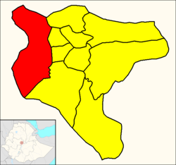 Kolfe Keranio (red) within Addis Ababa | |
 Kolfe Keranio Location in Ethiopia | |
| Coordinates: 9°0′49.75″N 38°42′21.49″E / 9.0138194°N 38.7059694°E | |
| Country | |
| City | Addis Ababa |
| Area | |
| • Total | 61.25 km2 (23.65 sq mi) |
| [1] | |
| Population (2011) | |
| • Total | 546,219[1] |
| Time zone | UTC+3 (East Africa Time) |
| Area code | (+251) 11 |
Kolfe Keranio (Amharic: ኮልፌ ቀራኒዮ ክፍለ ከተማ), also spelled Kolfe Keraneo or simply Kolfe, is a district of Addis Ababa, Ethiopia. As of 2011 its population was of 546,219.[1]
Geography
The district is located in the western suburb of the city, near the Gefersa Reservoir. It borders with the districts of Gullele, Addis Ketema, Lideta and Nifas Silk-Lafto.
List of places
- Jemo 2
- Mickey Ieland Condo Site
- Repi Upper
Admin Level: 11
- Asko Area
- Asko Bercheko Faberika Area
- Atena Tera
- Ayer Tena
- Gebre Kirstos Bete Kristian
- Kolfe Keranio
- Koshim
- Kurtume Stream
- Lekwuanda
- Lideta Gebriel Bete Kristian
- Nefro Neighborhood
- Sost Kuter Mazoria (Total)
- Zenebework
- Asera Sement Mazoria(Asra sement)
References
- ^ a b c d "Kolfe Keranio Archived December 3, 2013, at the Wayback Machine". City Government of Addis Ababa.
External links
- Google. "Kolfe Keranio" (Map). Google Maps. Google.
| History | |||||
|---|---|---|---|---|---|
| Districts | |||||
| Squares | |||||
| Transport | |||||
| Landmarks | |||||
| Education |
| ||||
This Ethiopia location article is a stub. You can help Wikipedia by expanding it. |