To install click the Add extension button. That's it.

The source code for the WIKI 2 extension is being checked by specialists of the Mozilla Foundation, Google, and Apple. You could also do it yourself at any point in time.

4,5
Kelly Slayton
Congratulations on this excellent venture… what a great idea!
Alexander Grigorievskiy
I use WIKI 2 every day and almost forgot how the original Wikipedia looks like.
Live Statistics
English Articles
Improved in 24 Hours
Added in 24 Hours
What we do. Every page goes through several hundred of perfecting techniques; in live mode. Quite the same Wikipedia. Just better.
.
Leo
Newton
Brights
Milds

Khuroson District

From Wikipedia, the free encyclopedia

Khuroson District
Russian: Хуросонский район
Tajik: Ноҳияи Хуросон
Location of the district in Tajikistan
Coordinates: 38°05′N 68°40′E / 38.083°N 68.667°E / 38.083; 68.667
Country Tajikistan
RegionKhatlon Region
CapitalObikiik
Area
 • Total900 km2 (300 sq mi)
Population
 (2020)
 • Total116,500
 • Density130/km2 (340/sq mi)
Time zoneUTC+5
Official languages
Websitebalkhi.tj

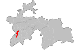
Khuroson District (Russian: Хуросонский район; Tajik: Ноҳияи Хуросон, 1991–2004: Ghozimalik District, before 1991: Ilyichyovskiy District)[2] is a district in Khatlon Region of Tajikistan. It extends south from national capital Dushanbe toward the regional capital Bokhtar.[3] Its capital is the town Obikiik (former name: Pravda). The population of the district is 116,500 (January 2020 estimate).[4]

Administrative divisions

The district has an area of about 900 km2 (300 sq mi) and is divided administratively into one town and five jamoats.[5] They are as follows:[6]

Jamoat Population (Jan. 2015)[6]
Obikiik (town) 8,500[7]
Ayni 26,724
Fakhrobod 12,264
Ghallaobod 18,253
Hiloli 18,426
Qizilqal'a 17,607

References

  1. ^ "КОНСТИТУЦИЯ РЕСПУБЛИКИ ТАДЖИКИСТАН". prokuratura.tj. Parliament of Tajikistan. Retrieved 9 January 2020.
  2. ^ Хуросонский район
  3. ^ Republic of Tajikistan, map showing administrative division as of January 1, 2004, "Tojikkoinot" Cartographic Press, Dushanbe
  4. ^ "Population of the Republic of Tajikistan as of 1 January 2020" (PDF) (in Russian). Statistics office of Tajikistan. Archived from the original (PDF) on 1 June 2021. Retrieved 9 October 2020.
  5. ^ "Regions of the Republic of Tajikistan 2017" (PDF) (in Russian). Statistics office of Tajikistan. pp. 15–21. Archived from the original (PDF) on 28 March 2022. Retrieved 12 October 2020.
  6. ^ a b Jamoat-level basic indicators, United Nations Development Programme in Tajikistan, accessed 9 October 2020
  7. ^ "Population of the Republic of Tajikistan as of 1 January 2015" (PDF) (in Russian). Statistics office of Tajikistan. Archived from the original (PDF) on 2 July 2015.
This page was last edited on 12 October 2023, at 16:45
Basis of this page is in Wikipedia. Text is available under the CC BY-SA 3.0 Unported License. Non-text media are available under their specified licenses. Wikipedia® is a registered trademark of the Wikimedia Foundation, Inc. WIKI 2 is an independent company and has no affiliation with Wikimedia Foundation.