
Hijlaard
Hilaard | |
|---|---|
Village | |
 Canal view | |
 Flag  Coat of arms | |
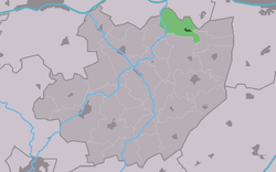 Location in the former Littenseradiel municipality | |
 Hijlaard Location in the Netherlands  Hijlaard Hijlaard (Netherlands) | |
| Coordinates: 53°9′55″N 5°42′38″E / 53.16528°N 5.71056°E | |
| Country | |
| Province | |
| Municipality | |
| Area | |
| • Total | 4.92 km2 (1.90 sq mi) |
| Elevation | 0.5 m (1.6 ft) |
| Population (2021)[1] | |
| • Total | 295 |
| • Density | 60/km2 (160/sq mi) |
| Postal code | 9027[1] |
| Dialing code | 058 |
Hilaard (Dutch: Hijlaard) is a village in Leeuwarden municipality in the province of Friesland, the Netherlands. It had a population of around 297 in January 2017.[3]
History
It was first mentioned in 1329 as Elawerth, and means "settlement of the people of Ele (person / noble man)".[4] Hilaard is a terp (artificial living mound) village from the middle ages. The John the Baptist Church has a 13th century tower. The church itself dates from the 15th or 16th century. The Bolswarder Tolhuis is a former toll house and has a 1652 weapon of the city of Bolsward for whom the toll was collected.[5] In 1840, Hilaard was home to 229 people.[6]
Before 2018, the village was part of the Littenseradiel municipality.[6]
Gallery
-
 John the Baptist Church
 -
 House with solar panels
 -
 Village view
 -
 Village view
References
- ^ a b c "Kerncijfers wijken en buurten 2021". Central Bureau of Statistics. Retrieved 30 March 2022.
two entries
- ^ "Postcodetool for 9027BA". Actueel Hoogtebestand Nederland (in Dutch). Het Waterschapshuis. Retrieved 30 March 2022.
- ^ Aantal inwoners per dorp Archived 2017-04-21 at the Wayback Machine - Littenseradiel
- ^ "Hilaard - (geografische naam)". Etymologiebank (in Dutch). Retrieved 30 March 2022.
- ^ Ronald Stenvert & Sabine Broekhoven (2000). "Hilaard" (in Dutch). Zwolle: Waanders. ISBN 90 400 9476 4. Retrieved 30 March 2022.
- ^ a b "Hilaard". Plaatsengids (in Dutch). Retrieved 30 March 2022.
.
External links
 Media related to Hilaard at Wikimedia Commons
This Friesland location article is a stub. You can help Wikipedia by expanding it. |