
| Greensand Way | |
|---|---|
 | |
| Length | 174 km (108 mi)[1][2] |
| Location | South Eastern England, United Kingdom |
| Trailheads | Haslemere, Surrey Hamstreet, Kent |
| Use | Hiking |
| Highest point | Leith Hill, 294 m (965 ft)[3] |
| Season | All year |
The Greensand Way is a long-distance path of 108 miles (174 km) in southeast England, from Haslemere in Surrey to Hamstreet in Kent.[1][2] It follows the Greensand Ridge along the Surrey Hills and Chart Hills. The route is mostly rural, passing through woods, and alongside fruit orchards and hop farms in Kent and links with the Stour Valley Walk near Pluckley in Kent. The trail was opened on 15 June 1980 and is jointly managed by Surrey and Kent Councils who fully updated it in 2012 (route, waymarking, online guide).
Much of the land is designated an Area of Outstanding Natural Beauty (AONB). The stretch from Hindhead to Leith Hill has formed part of the Surrey Hills AONB since 1958. The Sevenoaks Ridge, from the Surrey–Kent border to Borough Green, is included in the Kent Downs AONB.
The waymarks alone are not sufficient to follow the trail – an OS map, or the online guide with maps, is required.[4] An updated guide with maps and walk directions is available online from the Kent and Surrey Council websites. The original guidebook is out of print.[5] On Ordnance Survey Explorer map 145, a spur – also labelled Greensand Way – is shown from Thursley to Farnham; this is not part of the path.
YouTube Encyclopedic
-
1/3Views:672766307
-
Time Out Country Walks, Book 1, Walk 50, Yalding to Borough Green. 28/10/12.
-
SWC Free Walks 151/152, Lenham to Ashford.1/7/12
-
Time Out Walks: Book 1, Walk 20, Milford to Godalming. Part 1. 3/5/10.
Transcription
Places en route
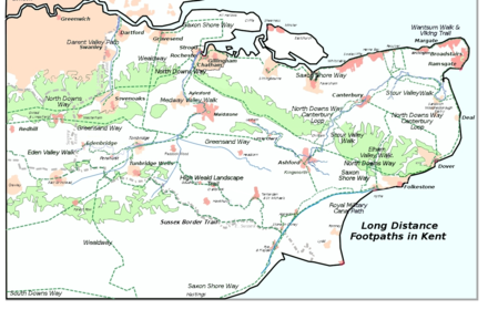
Places passed along the trail include: Hindhead, Thursley, Wormley, Hambledon, Hascombe, Shamley Green, Holmbury St Mary, Wotton, Westcott, Dorking, Brockham, Betchworth, Reigate, Earlswood, South Nutfield, Bletchingley, Godstone, Tandridge, Broadham Green, Limpsfield, Crockham Hill, Toys Hill, Ide Hill, Sevenoaks Weald, Knole Park, Shipbourne, Dunk's Green, West Peckham, Nettlestead Green, Yalding, Linton, Sutton Valence, Egerton, Pluckley, Little Chart, Hothfield, Kingsnorth and finally Hamstreet.
References
- ^ a b "Greensand Way".
- ^ a b "The Greensand Way long distance route".
- ^ National Trail
- ^ "Greensand Way". 16 January 2019.
- ^ Drewett, J (1985). "Chapter 1: Landscape and Countryside". Surrey. Shire County Guides (2nd ed.). Princes Risborough: Shire Publications. p. 8. ISBN 978-0-7478-0051-4.
- The Greensand Way in Kent, 1992, Kent County Council, ISBN 1-873010-23-0 (Out of print)
- Colton, Adam Mud, Sweat and Beers ISBN 9780954477110
External links
- Kent Council – Homepage and online guide with maps of Kent and Surrey sections of the walk
- Surrey Council – Homepage and online guide with maps of Surrey section of the walk
- Saturday Walkers Club – Description, GPS data, and OS map of walk
- Route of the Greensand Way on OpenStreetMap (takes a long time to load e.g. 25 seconds)