

Original file (4,231 × 6,951 pixels, file size: 27.99 MB, MIME type: image/jpeg)
| This is a file from the Wikimedia Commons. Information from its description page there is shown below. Commons is a freely licensed media file repository. You can help. |
Summary
| Description |
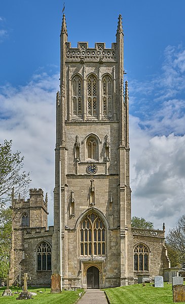
This is a wonderful Somerset church, one of the finest in a county known for its fine churches. Described by the architectural expert Simon Jenkins as "Somerset architecture at its most powerful", the chief feature is its substantial 102 feet high west tower, accompanied uniquely by a smaller and older tower over the north porch.
The oldest parts of the church are the north nave aisle and north tower, dating from the mid 14th century. In the mid to late 15th century, the church was expanded significantly by building a new and larger nave and tower to the south of the building, making the original church the aisle of the new. In the 18th century, the east end and chancel were rebuilt in the Rococo or Late Baroque style, which contrasts with the rich Perpendicular Gothic of the nave. The tower, one of the "Mendip group", contains a heavy and rich sounding peal of six bells, including the oldest bell in Somerset that has an exact known date of casting. The tenor bell weighs just shy of 26cwt or 1309kg, and is a fine bell, by Taylor's of Loughborough, dating from 1930. Taken on 26/05/2021. |
| Date | |
| Source | https://www.flickr.com/photos/cathedraljack/51207424127/ |
| Author | JackPeasePhotography |
| Camera location | | View this and other nearby images on: OpenStreetMap |
|---|
Licensing
- You are free:
- to share – to copy, distribute and transmit the work
- to remix – to adapt the work
- Under the following conditions:
- attribution – You must give appropriate credit, provide a link to the license, and indicate if changes were made. You may do so in any reasonable manner, but not in any way that suggests the licensor endorses you or your use.
| This image was originally posted to Flickr by JackPeasePhotography at https://flickr.com/photos/76253421@N04/51207424127. It was reviewed on 1 December 2022 by FlickreviewR 2 and was confirmed to be licensed under the terms of the cc-by-2.0. |
File history
Click on a date/time to view the file as it appeared at that time.
| Date/Time | Thumbnail | Dimensions | User | Comment | |
|---|---|---|---|---|---|
| current | 12:21, 1 December 2022 | | 4,231 × 6,951 (27.99 MB) | أيوب | Uploaded a work by JackPeasePhotography from https://www.flickr.com/photos/cathedraljack/51207424127/ with UploadWizard |
File usage
Global file usage
The following other wikis use this file: