

Original file (2,441 × 3,257 pixels, file size: 575 KB, MIME type: image/png)
| This is a file from the Wikimedia Commons. Information from its description page there is shown below. Commons is a freely licensed media file repository. You can help. |
Summary
| Description |
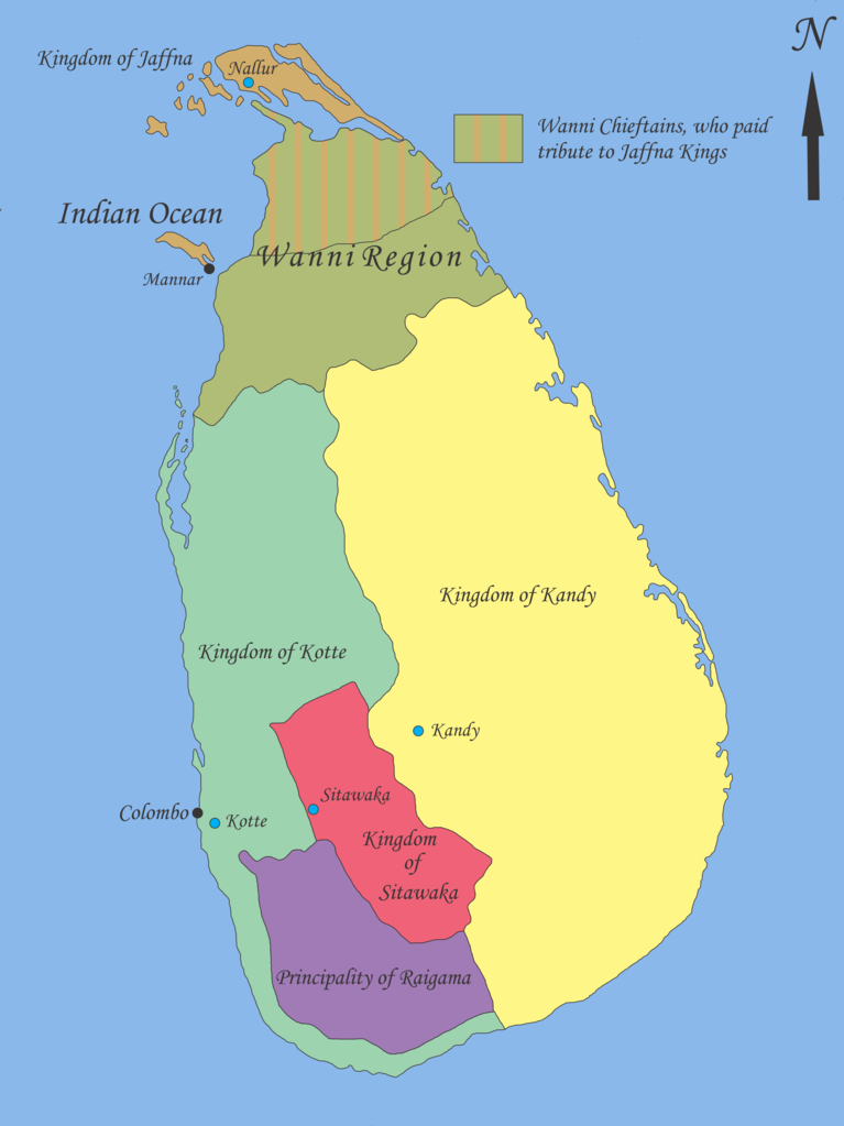
Map showing geopolitical situation in Sri Lanka in the early part of 16th century after the “Spoiling of Vijayabahu” in 1521. Map based on following sources;
- “Year 8 History Text Book – Government Publication”, THE ARRIVAL OF THE PORTUGUESE IN SRI LANKA: p14, 06th September 2012. -Fernao de Queyroz. The temporal and spiritual conquest of Ceylon. AES reprint. New Delhi: Asian Educational Services; 1995. p 47-58 ISBN 81-206-0765-1 -Captain Joao Ribeiro. The historic Tragedy of the island of Ceilao. AES Reprint. New Delhi: Asian Educational Services; 1999. p5 ISBN 81-206-1334-1 -Phillipus Baldaeus. A True and Exact Description of the Great Island of Ceylon. English Translation by Pieter Brohier. The Ceylon Historical Journal – Published in Co-operation with the Ceylon Branch of Royal Asiatic Society. Volume III, No 1-4; July 1958 to April 1959. p 300-301 Following maps were used to identify limitations of areas and not for the map itself. -DE L'ISLE:G. - Carte de l'Isle de Ceylan. Published in Paris 1723. http://www.swaen.com/antique-map-of.php?id=1777 , 06 September 2012 - VALENTIJN,F. - Nieuwe Kaart van het Eyland Ceylon opgestelt door. Published in Amsterdam 1724 http://www.swaen.com/antique-map-of.php?id=736 |
| Date | |
| Source | Own work |
| Author | Nishadhi |
Licensing
- You are free:
- to share – to copy, distribute and transmit the work
- to remix – to adapt the work
- Under the following conditions:
- attribution – You must give appropriate credit, provide a link to the license, and indicate if changes were made. You may do so in any reasonable manner, but not in any way that suggests the licensor endorses you or your use.
- share alike – If you remix, transform, or build upon the material, you must distribute your contributions under the same or compatible license as the original.

|
Permission is granted to copy, distribute and/or modify this document under the terms of the GNU Free Documentation License, Version 1.2 or any later version published by the Free Software Foundation; with no Invariant Sections, no Front-Cover Texts, and no Back-Cover Texts. A copy of the license is included in the section entitled GNU Free Documentation License. |
Original upload log
- 2012-09-21 18:02 Nishadhi 2441×3257× (589067 bytes) Spelling mistake corrected.
- 2012-09-16 15:48 Nishadhi 2441×3257× (589023 bytes) Map showing geopolitical situation in Sri Lanka in the early part of 16th century after the “Spoiling of Vijayabahu” in 1521. Map based on following sources; - “Year 8 History Text Book – Government Publication”, THE ARRIVAL OF THE PORTUGUESE...
File history
Click on a date/time to view the file as it appeared at that time.
| Date/Time | Thumbnail | Dimensions | User | Comment | |
|---|---|---|---|---|---|
| current | 19:04, 25 December 2014 | | 2,441 × 3,257 (575 KB) | OgreBot | (BOT): Reverting to most recent version before archival |
| 19:04, 25 December 2014 |  | 2,441 × 3,257 (575 KB) | OgreBot | (BOT): Uploading old version of file from en.wikipedia; originally uploaded on 2012-09-16 15:48:39 by Nishadhi | |
| 18:25, 21 September 2012 |  | 2,441 × 3,257 (575 KB) | Nishadhi | {{Information |Description ={{en|1=Map showing geopolitical situation in Sri Lanka in the early part of 16th century after the “Spoiling of Vijayabahu” in 1521. Map based on following sources; - “Year 8 History Text Book – Government Public... |
File usage
Global file usage
The following other wikis use this file:
- Usage on ca.wikipedia.org
- Usage on de.wikipedia.org
- Usage on fi.wikipedia.org
- Usage on fr.wikipedia.org
- Usage on it.wikipedia.org
- Usage on ka.wikipedia.org
- Usage on ko.wikipedia.org
- Usage on my.wikipedia.org
- Usage on nl.wikipedia.org
- Usage on pl.wikipedia.org
- Usage on pt.wikipedia.org
- Usage on si.wikipedia.org
- Usage on sl.wikipedia.org
- Usage on ta.wikipedia.org
- Usage on ur.wikipedia.org
- Usage on zh.wikipedia.org