

Size of this preview: 800 × 438 pixels. Other resolutions: 320 × 175 pixels | 640 × 350 pixels | 1,024 × 560 pixels | 1,280 × 700 pixels | 3,067 × 1,678 pixels.
Original file (3,067 × 1,678 pixels, file size: 719 KB, MIME type: image/png)
| This is a file from the Wikimedia Commons. Information from its description page there is shown below. Commons is a freely licensed media file repository. You can help. |

|
This map image could be re-created using vector graphics as an SVG file. This has several advantages; see Commons:Media for cleanup for more information. If an SVG form of this image is available, please upload it and afterwards replace this template with
{{vector version available|new image name}}.
It is recommended to name the SVG file “Map of the Exclusive Economic Zones of the Pacific Ocean.svg”—then the template Vector version available (or Vva) does not need the new image name parameter. |
Summary
| Description |
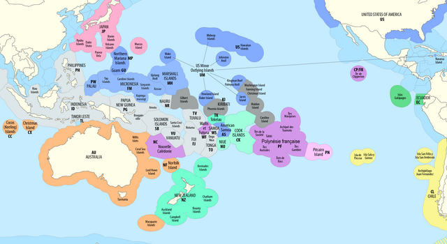
Exclusive Economic Zones (EEZ) of the Pacific Ocean
|
| Date | see file history |
| Source | Own work using: this map by B1mbo |
| Author | Maximilian Dörrbecker (Chumwa) |
| Permission (Reusing this file) |
I, the copyright holder of this work, hereby publish it under the following license: This file is licensed under the Creative Commons Attribution-Share Alike 2.5 Generic license.
Sie dürfen das Bild zu den folgenden Bedingungen nutzen:
|
| Other versions |
|
.png)


File history
Click on a date/time to view the file as it appeared at that time.
| Date/Time | Thumbnail | Dimensions | User | Comment | |
|---|---|---|---|---|---|
| current | 17:58, 5 February 2024 | | 3,067 × 1,678 (719 KB) | Janitoalevic | . |
| 22:37, 17 December 2022 |  | 3,067 × 1,678 (808 KB) | <bdi>Walterrs220</bdi> | Updated to reflect Micronesia's and Niue's free association status | |
| 12:52, 15 August 2022 |  | 3,067 × 1,678 (756 KB) | Zorion | Alle the French and Chilian islands with the name in the official languages | |
| 14:00, 12 June 2022 |  | 3,067 × 1,678 (711 KB) | Ham105 | Move Bougainville name to correct indicative position | |
| 05:45, 4 October 2018 |  | 3,067 × 1,678 (708 KB) | Chumwa | Reverted to version as of 06:01, 31 August 2018 (UTC) | |
| 05:44, 4 October 2018 |  | 2,919 × 1,676 (799 KB) | Chumwa | corr | |
| 06:01, 31 August 2018 |  | 3,067 × 1,678 (708 KB) | Chumwa | corr | |
| 05:10, 31 August 2018 |  | 3,067 × 1,678 (701 KB) | Chumwa | corr | |
| 19:17, 29 August 2018 |  | 3,067 × 1,678 (694 KB) | Chumwa | {{Information |Description= {{de|1=Ausschließliche Wirtschaftszonen (EEZ) im Pazifischen Ozean}} {{en|1=Territorial waters (EEZ) of the Pacific Ocean}} |Source = {{own using}} this map by {{U|B1mbo}} |Date = see file history |Author = Maximilian Dörrbecker (Chumwa) |Permission={{self|cc-by-sa-2.5}} Sie dürfen das Bild zu den folgenden Bedingungen nutzen: * Sie müssen den Namen des Autors nennen. * Im Falle eine... |
File usage
The following pages on the English Wikipedia use this file (pages on other projects are not listed):
Global file usage
The following other wikis use this file:
- Usage on af.wikipedia.org
- Usage on ar.wikipedia.org
- Usage on ast.wikipedia.org
- Usage on cs.wikipedia.org
- Usage on de.wikipedia.org
- Usage on es.wikipedia.org
- Usage on fa.wikipedia.org
- Usage on fr.wikipedia.org
- Usage on he.wikipedia.org
- Usage on id.wikipedia.org
- Usage on it.wikipedia.org
- Usage on ja.wikipedia.org
- Usage on pt.wikipedia.org
- Usage on ru.wikipedia.org
- Usage on tr.wikipedia.org
- Usage on uk.wikipedia.org
- Usage on xal.wikipedia.org