

Original file (1,600 × 1,200 pixels, file size: 1.65 MB, MIME type: image/jpeg)
| This is a file from the Wikimedia Commons. Information from its description page there is shown below. Commons is a freely licensed media file repository. You can help. |
| Description |
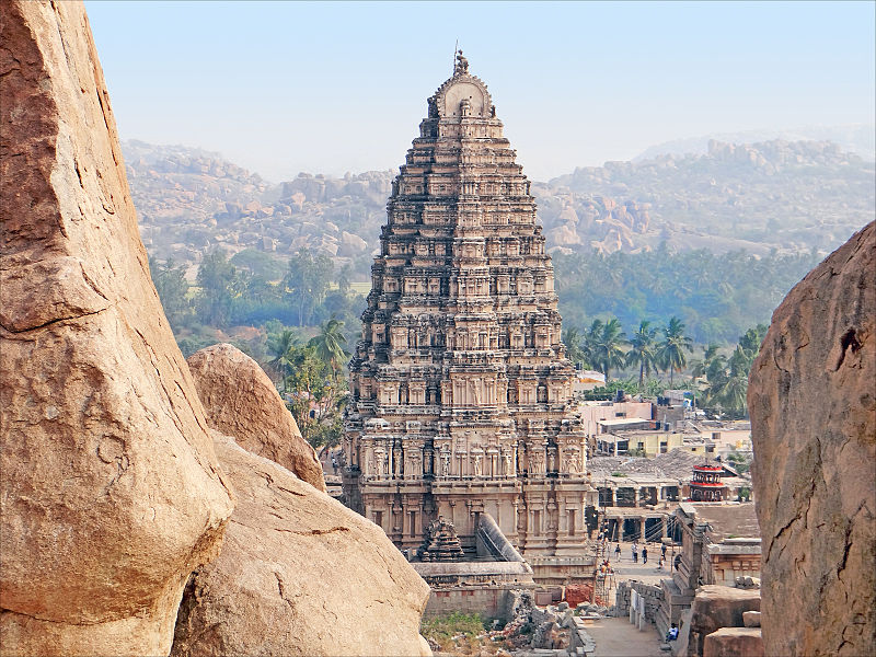
Virupaksha, a 7th century Hindu temple, is located in Hampi 350 km from Bangalore, in the state of Karnataka in southern India. It is part of the Group of Monuments at Hampi, designated a UNESCO World Heritage Site. Virupaksha is a form of Shiva and has other temples dedicated to him, notably at the Group of Monuments at Pattadakal, another World Heritage Site. In 1565, Muslim Sultanate army attacked the Hindu Vijayanagara kingdom and razed, depopulated, and destroyed Vijayanagar city and its numerous Hindu temples and icons, including Virupaksha, over a period of several months. They were rebuilt, in original style, by local Hindus, in 19th and 20th centuries. Le temple de Virupaksha est le plus ancien et le plus important de Hampi. C'est un centre de pèlerinage pour les dévôts de Shiva. Le premier sanctuaire, consacré à Pampa, une déesse locale, a été créé sur ce site au VIIè siècle. Par la suite, la déesse est devenue Virupaksha, une des formes de Parvati, la parèdre de Shiva, auquel elle a été symboliquement mariée. Le temple est situé sur la rive sud de la rivière Tungabadra, dans la ville sacrée. |
||
| Date | |||
| Source | Flickr: Le gopuram est du temple de Virupaksha (Hampi, Inde) | ||
| Author | Jean-Pierre Dalbéra | ||
| Permission (Reusing this file) |
This file is licensed under the Creative Commons Attribution 2.0 Generic license.
|
| Camera location | | View this and other nearby images on: OpenStreetMap |
|---|
File history
Click on a date/time to view the file as it appeared at that time.
| Date/Time | Thumbnail | Dimensions | User | Comment | |
|---|---|---|---|---|---|
| current | 23:08, 3 June 2014 | | 1,600 × 1,200 (1.65 MB) | <bdi>Flickr upload bot</bdi> | Uploaded from http://flickr.com/photo/72746018@N00/14250876721 using Flickr upload bot |
File usage
Global file usage
The following other wikis use this file:
- Usage on ar.wikipedia.org
- Usage on es.wikipedia.org
- Usage on fr.wikipedia.org
- Usage on hi.wikipedia.org
- Usage on it.wikipedia.org
- Usage on ja.wikipedia.org
- Usage on or.wikipedia.org
- Usage on sl.wikipedia.org
- Usage on sq.wikipedia.org
- Usage on ta.wikipedia.org
- Usage on te.wikipedia.org