
| Eyālet-i Edirne Еялет Адрианопол Εγιαλέτ της Αδριανούπολης | |||||||||||
|---|---|---|---|---|---|---|---|---|---|---|---|
| Eyalet of the Ottoman Empire | |||||||||||
| 1826–1867 | |||||||||||
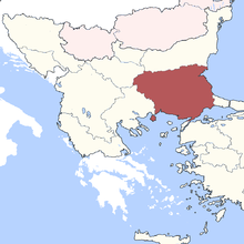 The Adrianople Eyalet in the 1850s | |||||||||||
| Capital | Edirne | ||||||||||
| Area | |||||||||||
| • Coordinates | 41°40′N 26°34′E / 41.667°N 26.567°E | ||||||||||
| Population | |||||||||||
• 1844 | 1,200,000[1] | ||||||||||
| History | |||||||||||
• Established | 1826 | ||||||||||
• Disestablished | 1867 | ||||||||||
| |||||||||||
| Today part of | Turkey Greece Bulgaria | ||||||||||
The Eyalet of Adrianople or Edirne[2] or Çirmen[3] (Ottoman Turkish: ایالت ادرنه; Eyālet-i Edirne)[4] was constituted from parts of the eyalets of Silistra and Rumelia in 1826.
It was one of the first Ottoman provinces to become a vilayet after an administrative reform in 1865, and by 1867 it had been reformed into the Vilayet of Adrianople.[5]
YouTube Encyclopedic
-
1/5Views:1 177 1351 7451 120447272 505
-
Türkiye Tarihi | Her Ay [1071-2021] - The History of Turkey | Every Month [1071-2021]
-
The Turkish Long War In 1591
-
The Turkish Long War Of 1591-1606 With The Habsburg Empire
-
The Bosnian Revolt Against Their Ottoman Overlords
-
Battle for Survival ⚔️ How did Alexios Komnenos save the Byzantine Empire? DOCUMENTARY
Transcription
Administrative division
The eyalet comprised almost all of the historical geographical region of Thrace, and comprised the following subdivisions (sanjaks or livas):[3][6]
- Sanjak of Nevahi-i Erbaa (capital: Çatalca)
- Sanjak of Tekfürtaği (Rodosto) or Vize
- Sanjak of Gelibolu (Gallipoli)
- Sanjak of Edirne (Adrianople)
- Sanjak of Filibe (mod. Plovdiv)
- Sanjak of Islimiye (mod. Sliven) or Eski Zagra (Stara Zagora)
The sanjaks were further subdivided into 50 kazas or prefectures.[3]
References
- ^ Michael R. Palairet (2003-11-13). The Balkan Economies C.1800-1914: Evolution Without Development. Cambridge University Press. p. 9. ISBN 978-0-521-52256-4. Retrieved 2013-06-01.
- ^ The English Cyclopaedia: Geography By Charles Knight
- ^ a b c Konortas, Paraskevas. Αδριανουπόλεως Βιλαέτιον προ του 1864. Θρακικός Ηλεκτρονικός Θησαυρός (in Greek). Retrieved 2 March 2013.
- ^ "Some Provinces of the Ottoman Empire". Geonames.de. Archived from the original on 28 September 2013. Retrieved 25 February 2013.
- ^ Almanach de Gotha: annuaire généalogique, diplomatique et statistique. J. Perthes. 1867. pp. 827–829. Retrieved 2013-06-01.
- ^ The three eras of Ottoman history, a political essay on the late reforms of ..., p. 75, at Google Books By James Henry Skene
This Ottoman Empire–related article is a stub. You can help Wikipedia by expanding it. |