
| Ebright Azimuth | |
|---|---|
 The monument sign for Ebright Azimuth, the highest point in Delaware as of September 2016 | |
| Highest point | |
| Elevation | 448 ft (137 m)[1][2] |
| Prominence | 32 ft (9.8 m)[3] |
| Listing | U.S. state high point 49th |
| Coordinates | 39°50′09″N 75°31′09″W / 39.83574°N 75.51915°W |
| Geography | |
 Ebright Azimuth Location of Ebright Azimuth in Delaware  Ebright Azimuth Ebright Azimuth (the United States) | |
| Location | New Castle County, Delaware, United States |
| Climbing | |
| Easiest route | Paved road |


The Ebright Azimuth is the point with the highest benchmark monument elevation in the U.S. state of Delaware. It is marked with a geodetic benchmark monument and has an elevation of 447.85 feet (136.50 m) above sea level. The only state high-point with a lower elevation is Britton Hill in the state of Florida at 345 feet (105 m) above sea level.
YouTube Encyclopedic
-
1/5Views:330801681791863
-
Highpointing: Ebright Azimuth, the highest point in Delaware - Rooftops of America
-
Delaware Highest Point - Ebright Azimuth (alt. 448 feet)
-
2005 High Points DE
-
Delaware Odd Geography
-
Highpointing: Woodall Mountain, the highest point in Mississippi - Rooftops of America
Transcription
Description
The Ebright Azimuth[4] is located about 6.5 miles (10.5 km) north of downtown Wilmington, Delaware, in far northern New Castle County, within a few feet of the Pennsylvania state line. It is near Concord High School, to the north of Naamans Road, at the middle of the intersection of Ebright Road and Ramblewood Drive. This is an entrance to the Dartmouth Woods development.
Surveying by Delaware Geological Survey personnel indicates that the mobile home park just west of Ebright Road is at least 2 feet (61 cm) higher than the benchmark.[1][2]
Ebright Azimuth is named after James and Grant Ebright, who owned the property on which the benchmark was placed.[4] An azimuth is an angular measurement in a spherical coordinate system.
Since the schematic photograph was taken the blue and yellow monument sign has been moved across the street closer to the geodetic marker. A curb extension has been installed, and the area around the sign has been modestly landscaped.
Radio tower history
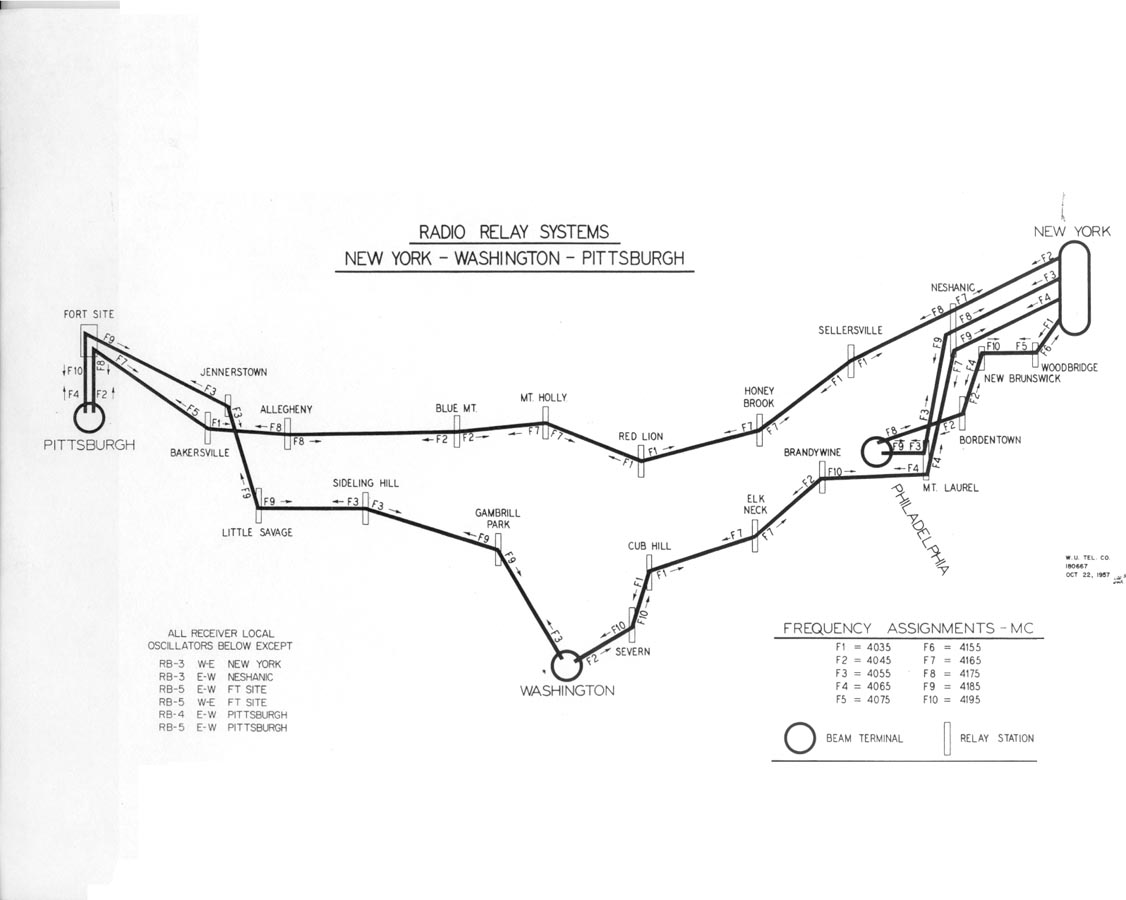
The self-supporting radio tower just south of the benchmark was constructed in 1947 by Western Union as part of a historic C-band microwave radio relay system that linked New York City and Washington, D.C. This site was assigned the name "Brandywine" in recognition of Brandywine Creek located several kilometers to the west and was licensed with the call sign KGB29.[5] Western Union's engineers specified a heavy-duty prefabricated fire tower structure, which allowed the microwave transmitters and receivers to be installed inside the cab. "Dish" antennas, mounted behind the window openings, were aimed towards the adjacent relay stations at Mt. Laurel, New Jersey, 33.8 miles (54.4 km) to the northeast, and Elk Neck near Elkton, Maryland, 30.5 miles (49.1 km) to the southwest.[6]
Like most of their early microwave relay sites, Western Union decommissioned the Brandywine installation near Ebright Azimuth as more-reliable broadband fiber systems were developed. The structure now supports several VHF and UHF land mobile radio antennas.
See also
References
- ^ a b "Highest Point in Delaware". Delaware Geological Survey. Retrieved 2008-12-17.
- ^ a b "Regarding the highest point in Delaware". Delaware Repeater Association. Archived from the original on 2009-03-06. Retrieved 2008-12-17.
- ^ "Ebright Azimuth, Delaware". Peakbagger.com. Retrieved 2012-10-17.
- ^ a b "Ebright". NGS Data Sheet. National Geodetic Survey, National Oceanic and Atmospheric Administration, United States Department of Commerce.
- ^ "Radio Stations Operated by the Western Union Telegraph Company" (JPG). Plant and Engineering Department. Western Union Telegraph Company (archived by A Secret Landscape). 1959. Retrieved 2008-12-17.
- ^ "Radio Relay Systems". New York, Washington, Pittsburg. archived by A Secret Landscape. Retrieved 2008-12-11.
External links
- "Historic Markers with Google Maps". State of Delaware. Retrieved 2008-12-17.