Cadastral in Queensland, Australia
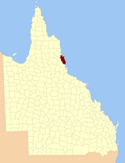
The county of Nares is a cadastral division of Queensland which contains the city of Cairns , Innisfail and most of the Atherton Tableland .[1] George Nares (1831–1915), a naval officer and commander of HMS Salamander .[2] 1911 Britannica .[3] Daintree River in the north.[4]
YouTube Encyclopedic
Healthcare Training: MRSA: How To Swab
Nasal mites: a tale of six dogs (and then one)
MOAH : FROSTIG COLLECTION AND MORE
Parishes Nares is subdivided into parishes, listed as follows:
Parish
LGA
Coordinates
Towns
Barron
Tablelands 17°15′S 145°29′E / 17.250°S 145.483°E / -17.250; 145.483 (Barron Parish ) Atherton , Tolga
Bartle Frere
Tablelands 17°25′S 145°45′E / 17.417°S 145.750°E / -17.417; 145.750 (Bartle Frere Parish )
Bellenden Ker
Cairns 17°20′S 145°53′E / 17.333°S 145.883°E / -17.333; 145.883 (Bellenden Ker Parish ) Babinda , Bellenden Ker , Miriwinni
Cairns
Cairns 16°53′S 145°40′E / 16.883°S 145.667°E / -16.883; 145.667 (Cairns Parish ) Cairns , Kuranda
Danbulla Tablelands 17°07′S 145°36′E / 17.117°S 145.600°E / -17.117; 145.600 (Danbulla Parish )
Dinden
Mareeba 17°00′S 145°34′E / 17.000°S 145.567°E / -17.000; 145.567 (Dinden Parish )
Dirran
Tablelands 17°30′S 145°37′E / 17.500°S 145.617°E / -17.500; 145.617 (Dirran Parish ) Tarzali , Millaa Millaa
Dulanban
Cairns 16°40′S 145°33′E / 16.667°S 145.550°E / -16.667; 145.550 (Dulanban Parish )
East Barron
Tablelands 17°19′S 145°33′E / 17.317°S 145.550°E / -17.317; 145.550 (East Barron Parish ) Yungaburra
Formartine
Mareeba 16°52′S 145°29′E / 16.867°S 145.483°E / -16.867; 145.483 (Formartine Parish )
Gadgarra
Tablelands 17°15′S 145°44′E / 17.250°S 145.733°E / -17.250; 145.733 (Gadgarra Parish )
Glady
Cassowary Coast 17°28′S 145°56′E / 17.467°S 145.933°E / -17.467; 145.933 (Glady Parish ) Flying Fish Point
Grafton
Cairns 17°05′S 145°44′E / 17.083°S 145.733°E / -17.083; 145.733 (Grafton Parish ) Edmonton , Gordonvale
Hull
Cassowary Coast 17°47′S 146°00′E / 17.783°S 146.000°E / -17.783; 146.000 (Hull Parish ) Silkwood , South Mission Beach , El Arish
Japoon
Cassowary Coast 17°44′S 145°55′E / 17.733°S 145.917°E / -17.733; 145.917 (Japoon Parish ) Japoon
Johnstone
Cassowary Coast 17°36′S 145°55′E / 17.600°S 145.917°E / -17.600; 145.917 (Johnstone Parish ) Innisfail , South Johnstone
Jordan
Cassowary Coast 17°39′S 145°45′E / 17.650°S 145.750°E / -17.650; 145.750 (Jordan Parish )
Malanda
Tablelands 17°22′S 145°37′E / 17.367°S 145.617°E / -17.367; 145.617 (Malanda Parish ) Malanda
Monamona
Mareeba 16°46′S 145°30′E / 16.767°S 145.500°E / -16.767; 145.500 (Monamona Parish )
Mourilyan
Cassowary Coast 17°37′S 146°03′E / 17.617°S 146.050°E / -17.617; 146.050 (Mourilyan Parish ) Mourilyan , parts of Innisfail
Palmerston
Cassowary Coast 17°34′S 145°45′E / 17.567°S 145.750°E / -17.567; 145.750 (Palmerston Parish )
Russell
Cairns 17°19′S 145°59′E / 17.317°S 145.983°E / -17.317; 145.983 (Russell Parish ) Bramston Beach
Smithfield
Tablelands 16°46′S 145°38′E / 16.767°S 145.633°E / -16.767; 145.633 (Smithfield Parish ) Northern Beaches
Sophia
Cairns 17°07′S 145°52′E / 17.117°S 145.867°E / -17.117; 145.867 (Sophia Parish ) Aloomba
Tinaroo
Mareeba 17°04′S 145°25′E / 17.067°S 145.417°E / -17.067; 145.417 (Tinaroo Parish ) Mareeba , Walkamin
Trinity
Cairns 16°58′S 145°49′E / 16.967°S 145.817°E / -16.967; 145.817 (Trinity Parish ) Yarrabah
References External links 16°55′S 145°47′E / 16.917°S 145.783°E / -16.917; 145.783
This page was last edited on 27 September 2023, at 23:02

![[1]](https://gisservices.information.qld.gov.au/arcgis/rest/directories/historicalscans/cad_scans/cad-map-2mile-county-nares-1919.jpg)