
Attécoubé
Abidjan Te | |
|---|---|
Suburb and urban commune | |
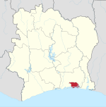
 Location in Abidjan | |
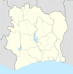 Attécoubé Location in Ivory Coast | |
| Coordinates: 5°20′N 4°2′W / 5.333°N 4.033°W | |
| Country | |
| District | Abidjan |
| Area | |
| • Total | 46.17 km2 (17.83 sq mi) |
| Population (2021 census)[1] | |
| • Total | 313,135 |
| • Density | 6,800/km2 (18,000/sq mi) |
| Time zone | UTC+0 (GMT) |
Attécoubé (Ebrié: Abidjan Te) is a suburb of and one of the 10 urban communes of Abidjan, Ivory Coast. It is situated to the northwest of Abidjan's central Plateau commune,[2] overlooking the Baie du Banco. Attécoubé has a total area of 46.17 square kilometres (17.83 sq mi), 30 square kilometres (12 sq mi) of which is covered by forest and 5 square kilometres (1.9 sq mi) by Ébrié Lagoon. The commune forms part of Banco National Park.[3]
The population was 164,751 in 1988, 214,638 in 1998,[4] and 260,911 in 2014.[5] At the beginning of the colonial era, Attécoubé was exploited by the French for its timber. Its mayor, elected in municipal elections in March 2001, is Danho Paulin.
YouTube Encyclopedic
-
1/1Views:516
-
Jerry Marathon Attecoube
Transcription
Districts
Attécoubé is separated into almost three dozen districts. These include:
Right bank
- Agban Attié
- Attécoubé 3
- Djéné Ecaré
- Santé Ecole
- Santé 3 Résidentiel 1
- Santé 3 Résidentiel 2
- Santé 3 Extension
- Fromager
- Déindé
- Asapsu
- Awa
- Jean-Paul 2
- Santé Carrefour
- Akélié
- Lackman
- Douagoville
- Camp Douane
- Jérusalem Résidentiel
- Jérusalem 1
- Jérusalem 2
- Jérusalem 3
Left bank
- Sebroko
- La Paix
- Lagune
- Espoir
- Mosquée
- Saint-Joseph
- Ecole
- Gbebouto
- Cantonnement Forestier
- Cité Fairmont 1
- Cité Fairmont 2
- Ecole Forestière
- Bidjanté
Notable people
- Noel Yobou (born 1982), footballer
- Chaka Traorè (born 2004), footballer
References
- ^ Citypopulation.de Population of boroughs and sub-prefectures of Abidjan
- ^ Gaston, Elaine (January 20, 2015). "Ark. church explores partnering with Ivorian believers". Baptist Press. Retrieved 13 February 2015.
- ^ Auzias, Dominique; Labourdette, Jean-Paul (26 November 2008). Côte d'Ivoire 2009-2010. Petit Futé. p. 171. ISBN 2-7469-2408-0.
- ^ Appessika, Kouamé (2003). "The case of Abidjan, Ivory Coast" (PDF). UNDERSTANDING SLUMS: Case Studies for the Global Report on Human Settlements 2003, Bureau National d'Etudes Techniques et de Development. p. 3. Retrieved 13 February 2015.
- ^ "Côte d'Ivoire". geohive.com. Retrieved 15 December 2015.
 | Urban communes (north) | 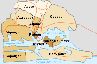 | |
|---|---|---|---|
| Urban communes (south) | |||
| Rural sub-prefectures (east) | |||
| Rural sub-prefectures (west) | |||
This Abidjan location article is a stub. You can help Wikipedia by expanding it. |