
Nogent-sur-Marne | |
|---|---|
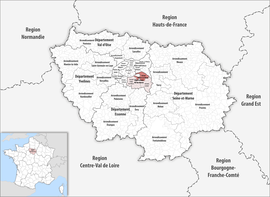 Location within the region Île-de-France | |
| Country | France |
| Region | Île-de-France |
| Department | Val-de-Marne |
| No. of communes | 13 |
| Subprefecture | Nogent-sur-Marne |
| Area | 56.3 km2 (21.7 sq mi) |
| Population (2021)[1] | 513,253 |
| • Density | 9,116/km2 (23,610/sq mi) |
| INSEE code | 942 |
The arrondissement of Nogent-sur-Marne is an arrondissement of France in the Val-de-Marne departement in the Île-de-France region. It has 13 communes.[2] Its population is 510,395 (2019), and its area is 56.3 km2 (21.7 sq mi).[3]
YouTube Encyclopedic
-
1/3Views:25 1187105 778
-
Driving In France-Nogent Sur Marne-Villiers Sur Marne 1/2
-
nogent sur marne 30062013
-
The Suburb of Old Paris & White Wine - Paris Live #90
Transcription
Composition
The communes of the arrondissement of Nogent-sur-Marne, and their INSEE codes, are:[2]
- Bry-sur-Marne (94015)
- Champigny-sur-Marne (94017)
- Charenton-le-Pont (94018)
- Fontenay-sous-Bois (94033)
- Joinville-le-Pont (94042)
- Maisons-Alfort (94046)
- Nogent-sur-Marne (94052)
- Noiseau (94053)
- Ormesson-sur-Marne (94055)
- Le Perreux-sur-Marne (94058)
- Saint-Mandé (94067)
- Villiers-sur-Marne (94079)
- Vincennes (94080)
History
The arrondissement of Nogent-sur-Marne was created in 1966 as part of the department Seine.[4] In 1968 it became part of the new department Val-de-Marne.[5] On 25 February 2017, it lost 3 communes to and gained 2 communes from the arrondissement of Créteil.[6]
As a result of the reorganisation of the cantons of France which came into effect in 2015, the borders of the cantons are no longer related to the borders of the arrondissements. The cantons of the arrondissement of Nogent-sur-Marne were, as of January 2015:[7]
- Bry-sur-Marne
- Champigny-sur-Marne-Centre
- Champigny-sur-Marne-Est
- Champigny-sur-Marne-Ouest
- Chennevières-sur-Marne
- Fontenay-sous-Bois-Est
- Fontenay-sous-Bois-Ouest
- Joinville-le-Pont
- Nogent-sur-Marne
- Ormesson-sur-Marne
- Le Perreux-sur-Marne
- Saint-Mandé
- Villiers-sur-Marne
- Vincennes-Est
- Vincennes-Ouest
References
- ^ "Téléchargement du fichier d'ensemble des populations légales en 2021". The National Institute of Statistics and Economic Studies. 28 December 2023.
- ^ a b "Arrondissement de Nogent-sur-Marne (942)". INSEE. Retrieved 2019-10-05.
- ^ "Comparateur de territoire, géographie au 01/01/2022". INSEE. Retrieved 11 January 2023.
- ^ Ancien département : la Seine
- ^ Historique du Val-de-Marne
- ^ "Arrêté préfectoral, 24 February 2017" (PDF). pp. 19–21. Retrieved 2019-10-29.
- ^ "Populations légales 2012: 94 Val-de-Marne" (PDF). INSEE. December 2014.
48°50′11″N 2°28′44″E / 48.83639°N 2.47889°E